
AXIS GeoSpatial provides more applications from one mapping effort.
Easton, Maryland-based AXIS GeoSpatial LLC provides geospatial data and solutions to federal, state, and local government agencies and private sector firms, especially aerial mapping services. Heights talked with Erica Insley, marketing director for the firm.
Heights: How did AXIS GeoSpatial get its start?
Erica Insley: Founded in 2001, AXIS GeoSpatial LLC is headquartered in Easton, Maryland, and we have branch offices in Colorado, Delaware, and New Jersey.
Within three years of forming, AXIS exceeded our five-year staffing and revenue business goals. In 2002, AXIS provided E-911 mapping to their first county client in Maryland, Caroline County. The success continued for the next several years with additional offices being opened in New York and Colorado.
In 2012, we purchased our first aircraft, a Cessna 206H, which, combined with the purchase of a Trimble Harrier 68i lidar sensor, provided clients with classified and unclassified lidar data sets.
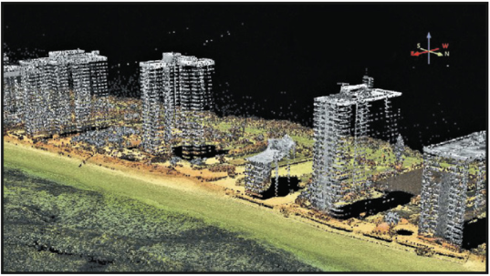
High-rise structures from a USGS GPSCIII countywide lidar collection in Florida.
In 2015, we experienced continued revenue and profitability growth within our land surveying and airborne acquisition divisions. AXIS purchased the Leica Nova MS50, a robotic total station and high-precision/long-range terrestrial laser scanner in one unit. The capability to remotely capture detailed, complex structures, and objects in 3D with great accuracy and acquire large data sets in a short period of time means we will continue providing accurate, georeferenced, survey-grade data to our clients.
In 2016, AXIS purchased the RIEGL LMS-Q1560 dual lidar channel airborne laser-scanning system, becoming the first commercial firm based in the Eastern U.S. to own this sensor.
We have recently added a twin-engine Piper Navajo to our fleet and an UltraCam Eagle F100 large format aerial camera.
Heights: Tell us about your Maryland digital high-resolution aerial photography contract.
EI: In 2014, The Maryland Department of Information Technology awarded us with a five-year contract to provide digital high-resolution aerial photography and various additional geospatial data services for Maryland.
This multi-year, statewide, geospatial data contract provides for multi-band/multi-resolution digital orthoimagery, airborne lidar, planimetric data, landuse/landcover data, oblique imagery, and an independent quality-assurance program for all services. Since 2007, this is AXIS’ third statewide geospatial data contract issued by Maryland.
AXIS is currently working on the 2017 project, which involves the collection of new aerial photography to develop new statewide digital orthophotography suitable for use in 911-call taking and dispatch systems. The 2017 imagery covers 6,372 mi including 14 counties and Baltimore City. This area was last flown in 2014.
Heights: AXIS GeoSpatial recently acquired a RIEGL LMS-1560 lidar system. What were the selection criteria for this sensor? What types of applications are you finding it useful for?
EI: Precision and accuracy were some of the key selection criteria for purchasing this system. We needed a sensor that would allow us to provide our clients with the USGS QL2 vertical and horizontal accuracy specifications they were looking for. With this system, AXIS easily acquires 20 ppsm in a single flight line and also 3D data on sides of buildings with the system’s 8 degrees of oblique capability.
 AXIS has been providing standard QL-2 lidar data for USGS-type programs, but we’re experiencing tremendous growth and demand in our HD-lidar solution. This sensor operates two 400kHz simultaneously in one system as well as houses a medium-format color digital camera. With this dual sensor, we are able to acquire 15-25 ppm lidar data, achieving absolute vertical accuracy of >.05′ on well-defined points along with color stereo imagery in one flight mission.
Many of our clients are requesting this solution due to its capability of satisfying more applications, with greater detail and increased accuracy while decreasing overall project costs. For our state, county, and municipal clients, the lure is more applications served from one mapping effort. Geospatial data that supports the most stringent of design-scale applications provides many uses to more users, which means more stakeholders participate and support the program.