A surveyor with a construction company in Northern Ireland uses UAVs to develop highway construction and for adjoining quarry quantities.
Improving infrastructure has become crucial to local and global economies due to increased strain on roads and public transport from a rising population. When GRAHAM Construction and its partner, Farrans, were jointly awarded the contract in 2016 to build Northern Ireland’s new A6 highway, the team knew working efficiently would be key to success. (I’m a surveyor with GRAHAM.)
Costing $182 million in total, the three-year project began in April 2016, with the aim of constructing a 14 km road between Castledawson and Randalstown. As the A6 represents a key economic corridor between Belfast and Derry, it is a typically busy stretch of road. Ground investigations within the site boundaries across the road and seven quarries—four of which are currently used in operations—therefore need to be as efficient as possible to keep to the tight timescales and optimize operations.
By adopting unmanned aerial vehicles (UAVs) for its regular surveys, GRAHAM Construction has been able to not only save substantial time and costs but also improve surveyor safety when carrying out risky quarry surveys for accompanying cut-and-fill calculations.
Potential Dangers
Ensuring accurate and detailed elevation levels is a crucial part of earth excavation. However, GRAHAM Construction found that its previous method of performing regular cut-and-fill volume calculations using ground-based technology was time-consuming and expensive. Weekly and monthly measurements required, on average, two to three staff members over two to three days, while the significant data-processing and volume-calculation work that was needed following the terrestrial survey resulted in a time-consuming, labor-intensive process.
The safety of on-site quarry surveys was another critical consideration. Historically, surveyors would have to employ ground-based GPS equipment to take measurements in areas where there are sheer rock cliffs and large boulders, potentially putting themselves at risk. When GRAHAM Construction was looking at innovative ways of mapping the terrain, reducing risk to improve surveyor safety was essential.
Exploring Drones
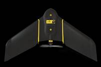
Korec Group is GRAHAM Construction’s primary supplier of geospatial equipment, and they were tasked with providing a viable alternative to traditional terrestrial surveying technology. An aerial approach offered logistical and safety advantages that would allow the team to securely map both quarry and road sites that were previously deemed unsafe and to optimize efficiencies. Following several demonstrations, GRAHAM Construction purchased a senseFly eBee Plus mapping drone.
To identify and map the contours of the terrain, we first deployed the eBee Plus to carry out a full topographic survey with GPS to work out the topsoil volume and the volumes of all topsoil stockpiles on site. Once a detailed topsoil strip model had been created, we deployed the UAV on a weekly basis, using the drone data to analyze the cost of the earthworks and to calculate the weekly cut-and-fill requirements.
Flying High
Flight planning software allows the UAV’s trajectory to be planned, simulated, and controlled to ensure safety and optimize results.
With the UAV solution, each individual flight can map a single 1,000 m (500 m in each direction) chainage along the road—a length determined to ensure compliance with UK commercial UAV regulations that specify visual line-of-sight.
Prior to each flight, the in-built eMotion software allowed the team to assess the feasibility of the project and plan their subsequent route by uploading a mission block of a 500 m by 50 m corridor and setting the take-off and landing zones.
Being able to outline the boundaries in advance helped to streamline processes and optimize the time spent analyzing data as only the imagery within the chainage parameters was processed—cutting out any extra data.
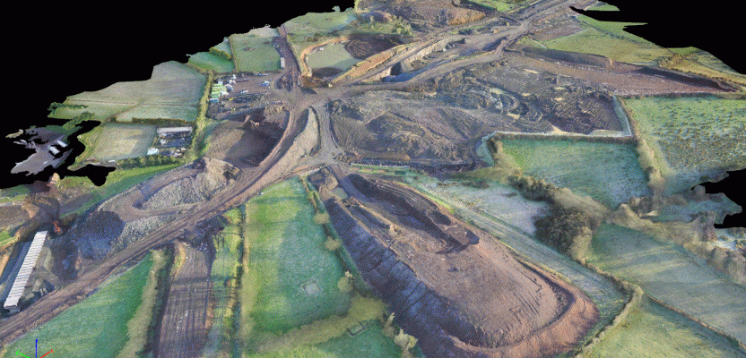
To map the new road, we used the drone at the current job site once a week and at four quarries. The data was subsequently processed using Pix4DMapper photogrammetry software to create detailed digital elevation models (DEMs), including digital point cloud and contour model outputs.
Using CAD software, the team was then able to determine precise volume calculations. This integrated approach used a similar workflow to survey several of the company’s on-site quarries, allowing them to map a crossover—part of a related contra-flow system.
Integrated Insights
Andy McIlwaine, a fellow land surveyor at GRAHAM Construction, commented, “The eBee Plus has revolutionized the laborious task of measuring our cut and fills each week. Previously, using robotic total stations and GPS took the team two to three days. Now, flying the sites with drones takes us only half a day.
“Plus, the technology has helped us to improve safety on each quarry survey by taking away the need to have surveyors on the ground on sites where drilling and blasting occur twice a week.
“Achieving the same depth of detail with UAVs means that an individual quarry survey now only takes ten minutes, compared to half a day using ground-based methods.”
In addition, GRAHAM Construction has made significant cost savings from using drones. Although initial outlays appeared high, the team recouped costs in several months, rather than years. A similar-sized contract awarded to the company in 2010 required 18 full-time surveyors, with four people taking measurements every day. In contrast, by using UAV solutions, the same results can now be achieved in one day.
Because the UAV can also be used outside the core job site, such as the crossover mapping, it has resulted in further cost savings. Previously, such extensive modeling would only be possible with a four-week application of traffic management, a day of on-the-ground organization with overnight cone placement, as well as the survey itself.
However, complex 3D CAD models can be easily generated from a ten-minute UAV flight and one hour of image processing, resulting in saving about $6,200 for one mission.
Similarly, thanks to the drone, the team is able to capture aerial photography at weekly intervals—an additional free advantage of the regular surveys that would usually cost up to $84,000 using a manned helicopter over the course of a project.
Using a UAV as part of an integrated, end-to-end approach, GRAHAM Construction has been able to collect highly accurate, professional aerial data for the new A6 road quickly and easily, helping to save valuable time and resources. Replacing traditional ground-based methods with UAV technology has not only helped to build a comprehensive view of the terrain but also reduced the risk of surveying dangerous quarry areas.
Following these insights, GRAHAM Construction will continue to use the eBee Plus for the duration of the project and is already looking to add a second drone to its operation to increase its cost and operational efficiencies across its infrastructure projects.
Image at top: Drone were used to capture aerial data across the road site and four quarries. DEMs were created using Pix4DMapper software, helping to determine cut-and-fill volume calculations.