All posts by Jeff Salmon

The (Android) Empire Strikes Back: Mainstreaming Augmented Reality, Part 2
Let’s pick up the AR thread again and look at what the Android platform has to offer in augmented reality (AR). It was just a matter of days after Apple rolled out its ARKit SDK (software development kit) when Google followed suit with its ARCore SDK. ARCore is built on Tango technology but expands the...

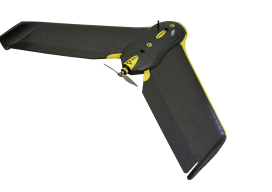
Drone Coding: Fun, Future, and Fundamentals
For Surveying’s Next Generation Attracting the next generation of surveyors is a perennial topic in the geospatial profession. I’d like to suggest adding K-12 UAS coding programs to the list of outreach efforts. The sooner students become interested in the geospatial field, the greater the success of attracting them to the profession. It is widely...

Geospatial to the Rescue
In view of recent weather-related events, we’ll take a quick detour from our series on AR (augmented reality) to cover RR (real reality): the catastrophic 2017 hurricane and wildfire season. The Caribbean islands, Florida, Louisiana, and Texas are reeling from the effects of hurricanes Harvey and Irma. As of this writing, Jose is only brushing...

Mainstreaming Augmented Reality: No Headset Required, Part 1
Augmented reality technology is rapidly evolving into the mainstream; now you can employ and enjoy AR on your smartphone. Let’s start with Apple’s ARKit, a software developers’ kit (SDK) for augmented reality. Apps developed on this platform will work with all iPhones and iPads that use the A9 or A10 processor and are running iOS...
UAVs Planting Trees
… And What That Means for Next-gen Drones Honestly, I don’t pay much attention to unusual uses of UAVs; I focus on geospatial applications. However, after reading the news about a company using UAVs to plant trees, perhaps I should. Let’s take a look at the story and see what it could mean for the...

Don’t Buy a Drone
Instead, invest in a fleet of drones. (Apologies for the clickbait headline!) While I was talking to a surveyor whose firm employs UAS in their work, he mentioned the different models of the craft they have. I interrupted him: “Just how many drones do you have?” “16” was the answer. This got me thinking about...