All posts by John Stenmark
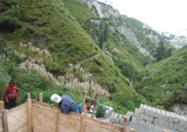
GNSS for Curingue: Accessing Remote Water Resources
A surveyor volunteers his time and expertise to help supply fresh water to Curingue, an isolated village in the Andes. Featured image: As part of the water project, Curingue residents work on building a structure for water collection, storage, and pumping. High in the Andes Mountains of Ecuador, the village of Curingue has no centralized...
Sponsored: Big Results in a Small Space
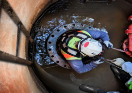
Image above: Towill surveyor James LaBasco makes the tight descent into the pipe. They used special safety equipment and procedures throughout the project. Sponsored by Trimble A California firm uses Trimble solutions to manage a tight schedule and difficult conditions. Total stations and scanning provide precise data for rehabilitating an aging water line. As buried water...
Motorized Trig Leveling
In Denmark, a new approach is boosting productivity in maintaining precise vertical data. EDITOR’S NOTE: Conventional surveying wisdom holds that differential and spirit leveling—and, specifically, digital—are superior to trigonometric leveling. But, with today’s improved instruments, software, and methods (developed over several decades of testing by many parties), results have shown that trig leveling can, if...

Strategic Movement: Precise Monitoring in Practice
A Danish company builds a successful monitoring business by leveraging technology and expertise. By John Stenmark, LS Newton’s laws of motion tell us that nothing moves if it isn’t pushed or pulled. That concept is behind the success of LE34, a Copenhagen-based surveying company that has built a business strategy around structural monitoring for a...

Sky Control: Lakhta is Russian Forward in Urban Development
Integrated geospatial solutions play a key part in building Europe’s tallest skyscraper. A new chapter in urban development is being written in Russia’s north-west corner. On the outskirts of Saint Petersburg, construction is underway on the new Lakhta Center, an ultra-modern facility that blends commerce, recreation, and cultural activities. In addition to incorporating hundreds of...
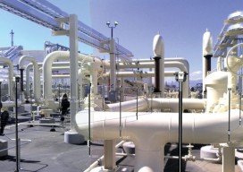
Creating Energy From Images
Geospatial information has long played an essential role in the energy industry, but now a new technology is cutting costs while improving the flow of knowledge. Editor’s note: The energy sector, oil and gas in particular, has grown more rapidly in the past half dozen years than in the past half a century. New fields,...