All posts by Matteo Luccio
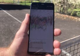
Apps: GnssLogger & Google’s Play in GNSS
GnssLogger? Many surveyors are familiar with the U.S. National Geodetic Survey’s Online Positioning User Service (OPUS), a cloud-based processing service that allows them to upload a Receiver-Independent Exchange (RINEX) file and receive results in minutes. Soon, they may be able to achieve centimeter accuracy by accessing raw GNSS measurements on their Android phone. Google announced...
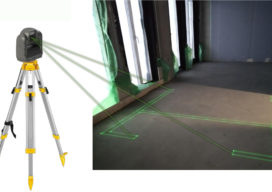
Seeing the Light: Laser Accuracy with LightXY
On a construction site, cement and concrete finishers, carpenters, framers, electricians, plumbers, flooring installers, and other trades people spend a lot of time taking measurements and interpreting blueprints before they can even start any of the specialized tasks they are trained and paid to perform. Until recently, it was not possible to project the blueprints...
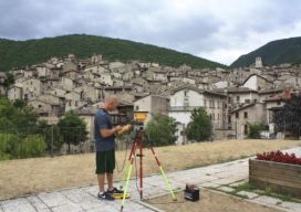
Ground Control Points as a Service?
Ground control points for aerial, satellite, and UAS imaging and remote sensing projects, large and small, can be downloaded on-demand—what a service! We look at an example service, and link to an upcoming webinar of the subject. With cameras pointed at Earth from hundreds of cubesats and tens of thousands of UAVs, in addition to...

Aerial Surveys Weathering Corporate Consolidations
How Aerial Surveys, an independent aerial photogrammetry company, survived the wave of consolidations and continues to grow. Featured image: An Aerial Surveys International aircraft flies the Colorado River in Utah. Aerial Surveys International (ASI), based in Watkins, Colorado, provides aerial photogrammetry services using digital mapping cameras, film cameras, and lidar devices. It has remained independent...
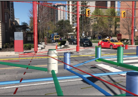
Hidden Infrastructure in 3D: Visualizing with AR
A visualization platform overlays data displays on your view of a job site by fusing data, AR software, and mobile-device sensors. From Superman’s x-ray vision, to current technologies that use radio waves to sense objects through walls. The ability, fictional or actual, to “see” through obstacles has long been a source of fascination. (Above: An...
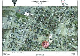
3D Evidence
Diagram software helps the New Mexico State Police enhance their extensive forensics work. Reconstructing what happened at the scene of a traffic accident or a crime is a complex undertaking involving scientific methods, physical evidence, deductive reasoning—and their interrelationships. It also requires hardware to gather data and software to analyze it and display it. Laser...