All posts by Nicholas Duggan FRGS Cgeog (GIS)
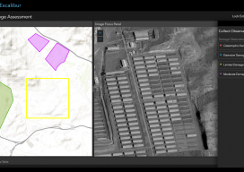
ArcGIS Excalibur
A new “un-GIS” GIS tool enables access, measurement, analysis, and markup capabilities for images – for everyone. Many years ago, during the era of cinematography and good old-fashioned film, they used to edit movies by cutting the film with a pair of 9-inch scissors; these were called “excalibur.” This sets the scene for the new...
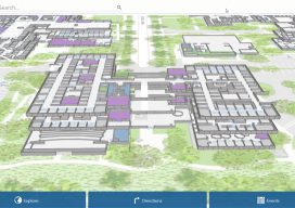
ArcGIS Indoors
What is it, and how will it work? Mapping has traditionally been the task of visually charting big outdoor spaces with pretty hills that look great with a few contours around them. Throw in a bit of hillshade, and you have a cartophile’s dream. The location intelligence company Esri, that has driven the market to...

Ocean Business 2019
With preliminary surveys already starting around the coast of the UK for another round of wind farms being built, the offshore industry descended on the National Oceanographic Centre in Southampton, UK for the bi-annual event, Ocean Business, centered around the offshore survey industry. Luckily, my home is a walk away from the event, so I was more than happy...

Who are the “Geo6” and why will this change UK geospatial?
Around the middle of 2017, there was a mumble in the geospatial industry about how the UK government was going to open up more of its geospatial data. There was even an outrageous rumor that Ordnance Survey was going to have to release its multimillion-pound product, Mastermap. Everyone sniggered but watched the news like hawks....
OS Zoomstack – the Gift that Keeps On Giving
On July 17 2018, Ordnance Survey (OS), the United Kingdom’s national mapping agency, released a trial of a product called “OS Zoomstack.” At the time many overlooked it, as Ordnance Survey makes lots of their data over 1:5000 available for free. I have to admit I was one of them. In August of last year,...
Where on Earth Is the Offset in ArcGIS Pro?
Life used to be nice and easy for us GIS guys. We used to roll out of bed, click start on our GIS software, go back to bed for an hour, and then think about making a nice simple 2D map. Then, all of a sudden everyone starts talking about 3D GIS and being able...