All posts by Sana Khushi, PhD
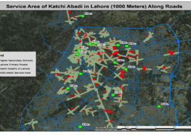
Data for Slums – A geospatial analysis of living conditions of the Pakistani poor helps to improve them.
The tendency for cities is to grow: spatially, by population, or both, and in Pakistan’s capital of Lahore, it’s been both. Urban growth leads to uncontrolled population and unplanned areas, usually along the edges of cities. Rapid urban population growth has outpaced the ability of city authorities to provide housing, environmental protections, and health infrastructure....
SWAMS
Using GIS for utility asset management: the Water Supply Asset Management System The cost of maintaining water system utilities is a concern of all responsible administrative authorities. And utilities are assets that need to be sustained rather than replaced again and again to provide people with quality service. Therefore, better asset management is needed; without...