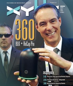
Autodesk and Leica Geosystems collaborate on a highly anticipated scanning solution, the BLK360: practical, high-precision reality capture for everyone.
We see so much written about 3D, BIM, and virtual and augmented worlds; it is easy to wax poetically about the potential for spatial analysis, automated feature recognition, space planning, and 3D design. There is much to be gained from 3D, including advanced simulations and operating “digital twins” (parallel in process and automation for plant, traffic, utilities, manufacturing, and construction).
But, the reality is that none of these is possible without capturing real-world 3D data, and lots of it, rapidly and precisely. We can’t produce any of the 3D magic without the digital raw materials.
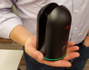
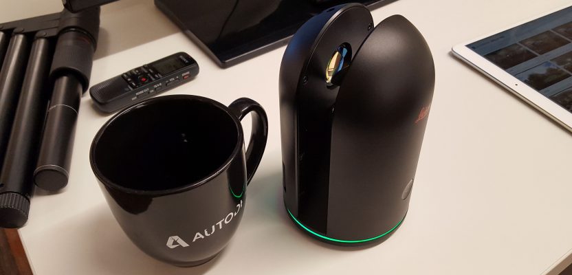
At just over a kilogram and fitting in the palm of your hand, the new BLK360 is a mobile sensor, collecting only data and images. Operation and processing is done on an iPad with Autodesk’s ReCap Pro mobile app.
SEEKING 3D NIRVANA
The predominant methods for 3D reality capture include static imaging (close-range and aerial photogrammetry, plus emerging single-image solutions), SLAM (simultaneous localization and mapping, via imaging and lidar that “paint” a model as sensors progress through the subject space), and traditional merged lidar clouds. Of these, the trophy for highest precision still belongs to the latter—it is difficult to beat a good laser scanner.
For decades, scanners have remained a relatively high-cost proposition, with a premium on experience and training for operators. Traditionally, high-precision scanning resided within the wheelhouse of surveyors (to ensure proper cloud registration and verifiable accuracies). Over the past two decades, expensive hardware and specialized software continued to be developed, broadening the base of practitioners, somewhat.
Hardware soon reached the “million points per second” range and was paired with imaging to yield true-color 3D deliverables. A mini-revolution in scanning occurred about a decade ago with the advent of lower-cost scanners like those from Faro and others. Next came the recent advent of practical target-less, cloud-to-cloud registrations, the addition of limited scanning capabilities to surveyors’ total stations, and tiny scanning pucks for all manner of mapping platforms.
“Non-traditional potential users and new entrants into the market: we wanted their first experience to be as delightful and as positive as possible.”
Users began to realize that not every application needed a gazillion points and often found the need to decimate such massive clouds for many practical uses. Fit-for-purpose solutions for scanning have become quite popular.
Now, Autodesk and Hexagon (parent company of Leica Geosystems) have collaborated on a precise, accessible, very portable, yet surprisingly low-cost scanning hardware/software solution: practical high-precision 3D reality capture for traditional and non-traditional users.
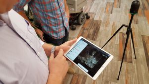
Autodesk’s Marc Zinck demonstrates the ReCap Pro mobile app. Scan data and images stream from the BLK360 as the scan progresses, including the cloud registration. You can add notes, photos, and even measure from the cloud directly on the tablet.
After the product was announced at Autodesk University 2016 (conference and exhibition), end-user communities have been eagerly anticipating getting their hands on the solution. This past summer, the units had begun to appear at resellers (see “Above and Below” below) and conferences. Numerous local chapters of professional associations have been hosting demonstrations. There was even a series of popular events hosted by the Australian Leica Geosystems reseller C.R. Kennedy (held at brew pubs) called, “BLK, BIM and Brew.” Some might question the wisdom of announcing a product before it was ready to hit the streets, but considering the interest generated, the adage, “hunger is the best sauce” might be spot on.
The Steel City Factor
Pittsburgh, historically famed for its steel, is gaining an international reputation as a hub for technology and, specifically, robotics. The city hosts several universities that are magnets for high-tech research and development. The roots of key elements of the BLK 360 and ReCap collaboration are homegrown in Pittsburgh and from alums of the prestigious science and technology giant, Carnegie Mellon University.
Host to prestigious science- and technology-focused academic institutions like Carnegie Mellon University (right), Pittsburgh (left) has become a magnet for research and development, particularly in robotics. Several local firms were integrated into the Autodesk facility there that developed the core of the ReCap family of products.
Aaron Morris formed Allpoint Systems in 2009, a startup specializing in data processing for 3D—for robotics, underground mapping, and other applications. He was soon joined by fellow Carnegie Mellon grad Marc Zinck, and they worked on lidar cloud-to-cloud registration. This would be key in the ReCap family of products.


Autodesk Pittsburgh resides at the renovated Bakery Square development and tech park.
Morris spoke about the early developments. “A lot of us come out of the robotics industry, and we did a lot of work taking what is available in the marketplace, usually only accessible to specialists, and making it more accessible for more users and applications.
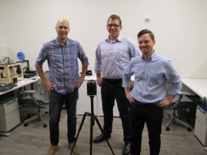
Ryan Frenz, Marc Zinck, and Aaron Morris: members of the Autodesk Pittsburgh team that developed key elements of the ReCap family of products, including the ReCap Pro mobile app that pairs with the BLK360.
“In working with a variety of scanners, we recognized that, if we could develop for something selling for under $20,000—if it was small, lightweight, and portable, with the right balance of ease-of-use in the software and verifiable high precision, more user [segments] could take advantage of scanning and 3D. We’d had several conversations with Leica [Geosystems], and this idea struck a chord. The collaboration began a few years ago.”
FIRST-TIME EXPECTATIONS
Aaron Morris, senior production and operations manager for reality solutions at Autodesk, told us, “We thought about the situation where you fire up your new scanner for the first time, and how difficult it is to get everything right. There is pressure from the job; you worry about getting fired.”
We visited Morris and his team in their lab at the Autodesk facility in Pittsburgh, Pennsylvania (see “The Steel City Factor”). Morris and his colleagues were responsible for much of the magic that goes into Autodesk’s ReCap family of products, including the ReCap Pro (desktop) and ReCap Pro’s mobile app (for iPad) that pair with the Leica Geosystems BLK360.
“Non-traditional potential users and new entrants into the market: we wanted their first experience to be as delightful and as positive as possible,” Morris said. “We had to think about how to make the process straightforward, with a simplified pipeline into tools that can use the data [CAD, design, and modeling software]. A lot of times it involved bringing in the specialist crew and the expensive gear.”
But there was another goal in this collaborative development, one that was the highlight of our test drive during the visit. As Morris noted, “We feel strongly that getting immediate feedback, being able to see the results on the spot in the app, to be able to check the quality—it puts you in the loop, in real time.”
A powerful little scanner would be the perfect fit for an intuitive and semi-automated workflow, one that Morris and his colleagues (and counterparts in Leica Geosystems) had been thinking about in parallel for many years.
Morris said, “My background at Carnegie Mellon University included working with the earliest scanning systems. Twelve years ago, a few of us assembled what was essentially a crude version of what this [BLK360] is. Our team had dreamed about this for a very long time. It is almost like a passion to work with this. Autodesk is not a hardware company, so we’ve enjoyed working with Leica Geosystems on this.”
Was there a lightbulb moment that brought the two teams together? Morris explained, “Leica Geosystems has a wide range of [equipment], from the DISTO [measurement and layout tools] all the way up to high-end scanners, like those surveyors would use, but not a lot in between.
“What we have seen in ReCap for years is that for the big customers—oil and gas, automotive manufacturers, shipping, civil design, and others—the value proposition is there for the high-end, specialized scanning.” Said Morris, “The question we kept coming back to: what is keeping that value proposition from broader markets?
“We had been talking to different hardware manufacturers and found that we had similar goals for this solution that the great engineering team at Leica [Geosystems] had. It just kind of happened at an event one year in a [casual] conversation that we reached the mutual conclusion of, ‘Why not?’”
Morris referred us to Burkhard Boeckem, chief technology officer for Leica Geosystems, for his insights on this collaboration.
Filling the Gap
AT THE SAME TIME that the Autodesk team was looking at a scanning and 3D processing solution to reach broader markets, Leica Geosystems had recognized the same potential. Leica Geosystems’ chief technology officer Burkhard Boeckem, who had worked closely with Aaron Morris on the collaboration, gave us some of his insights.
Hexagon’s chief technology officer, Burkhard Boeckem (Photo by Hexagon)
Boeckem said, “Leica Geosystems is well known for its laser scanning capabilities in the surveying, plant, and public safety sectors, but we recognized a gap in the market when it came to the AEC market. We began to look at how we could bring something to the market for these particular professionals. As we bounced off our idea of creating the BLK360 with the Autodesk team, we felt that the time is right to start the joint development of the reality capture experience.”
And what is Hexagon’s vision for the BLK360? Boeckem said, “We are committed to the idea of ‘democratizing technology,’ and the BLK360 is a major contribution to this path. We have been able to take exclusive technology developed by renowned experts at Hexagon and transform this into inclusive products and services that anyone can access.”

NOVICE TEST DRIVE
As the team explained it, the goal was a solution that would be easy enough for a novice to be able to simply turn on, with a minimum of training, and be successful on the first project. I took on the role of the novice.
Apart from an explanation by Morris’s team of what some of the icons meant, I found the BLK360 intuitive to use without having ever looked at the manual. What caught me by surprise, though, was how ReCap Pro’s mobile app did so much processing in the background, relentlessly working through the workflow and prompting the user only at key points along the way. I could almost picture it mocking me, saying, “Okay, I have to check in with the human.”
First, some of the basics. The BLK360 is a pretty amazing piece of hardware in its own right. To learn about it you should look at the full spec sheet online, but a few things stood out to me that I can share here.
It weighs less than 1.1Kg (2.4lbs)—such a contrast to days’ past when a decent scanner might run 24+Kg (50lbs). It operates in a range of +5 ̊C to +40 ̊C (41 ̊F to 104 ̊F), works indoors and out, and has no need for a cooling system (the metallic housing dissipates heat well; it never felt hot to the touch during our demo).
Its class 1, time-of-flight laser scans at up to 360,000 points per second through a field of view of 360 ̊ horizontal and 300 ̊ vertical at ranges of 0.6m to 60m (1.7’ to 197’). There are three predefined resolutions: high res at (for example) 7.5m range is 5x5mm, medium is 10x10mm, and low res is 15x15mm.There is a built-in IMU with auto-tilt.
It is only 165mm (6.5”) tall and 100mm (4”) in diameter— surprisingly small. It can be so small because it is simply a sensor; it only gathers data, and the processing is done on the tablet (and iPad Pro with iOS 10 or higher). Connection to the tablet is via wireless LAN (WiFi; 802.11 B, G, or N).
Unlike scanners that use the mirror for the imaging, the BLK360 has three fixed 5MP cameras aimed high, mid, and low (and one infrared). Each camera has calibrated flash LED illumination. The camera pass (that precedes each scan) yields a full 360 ̊ x 300 ̊ 130MP panorama. You should be able to get between 30 to 40 scans per recharge.
I have to mention the tripod. It is a non-traditional design but was easy to unfold and extend without any instructions. Unlike many tripods, when the legs retracted, it folds flat. It weighs less than a kilogram, and one design consideration was to be able to fit the BLK360 and tripod in a carry-on bag. So, someone could fly to far places, scan, verify the scans on the spot on the iPad, and be back on the plane in short order, confidently sipping a cocktail without having to deal with bulky and heavy gear.
The tripod folds flat and weighs less than a kilogram, so you can fit the BLK360 and tripod in a carry-on bag. Someone could fly to far places, scan, verify the scans on the spot on the iPad, and be back on the plane in short order, confidently sipping a cocktail without having to deal with bulky and heavy gear.
The BLK360 has a quick release on the tripod. I am sure that there will eventually be a 5/8”- 11” standard adapter for conventional rods, tripods, and bipods.
The only user interface on the unit is an on/off button; everything else is done on the iPad. Ryan Frenz, senior software development manager at the Autodesk Pittsburgh facility, said the iPad was the right choice for initial development of the app.
“Working with Apple on this, they really are on the cutting edge with regards to performance and battery life for tablets. It was a big piece of the work required to get this thing off the ground.”
Yes, it is limited to iPad at this time, but like with any engineering endeavor, users are asking for other platforms and operating systems. Frenz said they wanted to make sure the iOS is refined and then evaluate priorities.
Frenz noted that it was already paying off. “[We’ve provided the ability to accurately visualize, make it beautiful, make it fast, and get answers back immediately. The vision of the user simply pushing a button and some other person or machine is doing the work is not a great model; we hear from users all the time doing target-less and forgetting to scan some element, but you do not know until three days later when you’ve flown back to the office.”
Surveying, Scanning, 3D, and VR
HEXAGON GEOSYSTEMS executive vice president Ken Mooyman, began his career as a surveyor. We asked what his expectations were for the BLK360 package in the markets he oversees.
“My expectations are that the BLK360 solution will open up the reality-capture market much like GPS did for positioning,” Mooyman said. “The solution is extremely easy to use, quick, and inexpensive, which is lowering the barrier in all kinds of industries that are looking for digital reality content.”
Ken Mooyman posed with the new Leica Geosystems BLK360 at the Autodesk University 2016 product announcement. Adding a bit of light-hearted theater to the event, Mooyman was flanked by Leica Geosystems managers in sunglasses and earpieces, “Secret Service” style.
“I expect the professional applications using VR and AR will accelerate, as so many people will be using the BLK360 to collect and then share this real-world digital information as a base or background for these new applications. The content, in this case 3D reality, is king.”
Is this something surveyors could get excited about? Mooyman responded, “The social media feedback from the surveying community has been overwhelmingly positive. I personally have enjoyed viewing the numerous selfies showing proud surveyors and their new BLK360.
“Though the BLK360 was designed with technology democratization in mind for the AEC market, our traditional markets of surveyors are finding the imaging laser scanner just as useful. Some are pairing the BLK360 with our professional series ScanStations to capture small spaces with the BLK360 while the ScanStations do more of the heavy lifting.”
“START SCAN”
Morris’s team handed the BLK360 and iPad to me, pointing to the “Start Scan” icon. I set up (more like simply moved the tripod with BLK360 attached with one hand) progressively down the hallways. One click, and the BLK360 did a quick spin for imagery exposure, and then proceeded to a 45-second full-imagery scan followed by the full-dome scan, which can take from 30-90 seconds. In all, the process takes about three minutes.
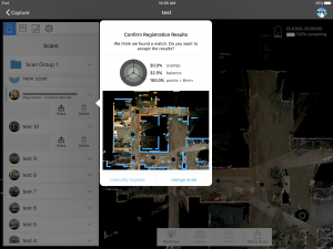
The mobile app on the iPad processes the scan as it is received from the BLK360. It begins to compare to previous scans (blue for existing, orange for new), suggesting a registration. The user can accept the merge at any time or opt to choose points common to scans for a manual registration. (Screeenshot from test drive, source: Autodesk.)
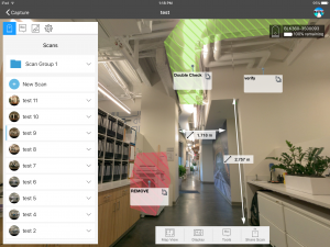
I was reminded to stay out of the view of the scanner, and then the progress showed up on the tablet in real time. Another small inset window showed the overlap with the previous scans: blue for existing and orange for the new scan. The automated registrations were great, but we did go through a manual registration (quite an intuitive process). Just pick well-defined common features (ceiling tiles and door frame corners worked well), and it will look for a matching pattern of points in 3D.
The app immediately began looking for common points to suggest a registration, and by zooming in that window I could see how walls and even individual shots lined up.
You do not have to wait for the full scan to register; if it looks like a good fit you can accept and the cloud continues to process the cloud, fully registered.
The automated registrations were great (well-defined features in the office space and good overlap), but we did go through a manual registration (quite an intuitive process). You do not have to zero-in on individual points; just pick well-defined common features (ceiling tiles and door frame corners worked well), and it will look for a matching pattern of points in 3D.
The mobile app on the iPad processes the scan as it is received from the BLK360. It begins to compare to previous scans (blue for existing, orange for new), suggesting a registration. The user can accept the merge at any time or opt to choose points common to scans for a manual registration. (Screeenshot from test drive, source: Autodesk)
On the tablet, we could visualize the full-color 3D cloud, and we checked the merged cloud for any problems (e.g. double walls or other misalignments) and to see if we missed anything—on the tablet and before leaving the site. Frenz also pointed out that, “The iPad has a camera, and we added a feature in ReCap Pro mobile where you can make an annotation, take notes, and attach an image—like a valve or machine plate—and attach that to the 3D note.”
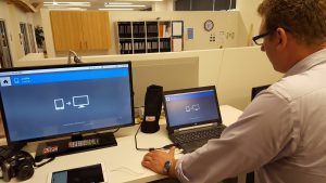
Uploading to ReCap Pro (in this instance to a Win 10 laptop via high speed USB) enables cleanup routines, export to common scanner data formats, and attaching the project to 10 other Autodesk design software packages.
With 10 scans completed, Marc Zinck, software development manager, demonstrated ReCap Pro. We connected to a laptop (Win 10 OS) via a high-speed USB and uploaded the data (about 10 minutes). In ReCap Pro, we worked with the full 3D cloud to measure and edit, and there is a pano viewer for ReCap Pro: RealView, a nice way to navigate and visualize. An indexing step (30s sec. to one minute per scan) prepares newly imported point clouds for fast 3D visualization and manipulation.
Zinck demonstrated a service available for ReCap Pro called Cleanup, for “noise cleanup” or “noise filtering.” On a scan previously done outside, Zinck showed how, for instance, the classification tool could identify (for removal) the “ghosts” of people and cars moving through the site.
The native format for the cloud data is Autodesk’s RCP, so we could bring it directly into AutoCAD. Zinck noted that the data attaches or imports directly to 10 of Autodesk’s software platforms, including Revit, Infraworks, Navisworks, and Civil 3D.
He took objects created in Navisworks (tables and chairs) and dropped them into the 3D model. I noticed models of sport cars in his Navisworks library, and for grins we verified that two of them could fit in the kitchen area.
ReCap Pro supports other formats like E57, LAS and LAZ, so the user can export to other software packages for more editing and analysis, like Leica Geosystem’s Cyclone. On that note, Leica Geosystems has BLK360 support in its full line of registration software solutions, including the new REGISTER 360 application.
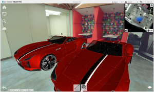
We took a processed scan of a room at the Autodesk Pittsburgh offices, went through a scan-to-mesh process, and (for fun) dropped in some Navisworks generated 3D models into this room.
On an outdoor scan, there was little difference in what you would see from or could do with a larger scanner (just with a shorter range). I could imagine doing a simple two-setup scan for, say, a wheelchair ramp project in about 15 minutes, including picking up visible registration points with a GNSS rover.
Above and Below
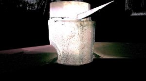
NOAR technologies has found success in scanning sewer/drainage maintenance holes with an inverted BLK360. 3D modelling of such structures has traditionally been a challenge with full-sized scanners and imaging systems. (Image credit – NOAR Technologies)
CHAD STUDER, president and owner of NOAR Technologies in Troy, Michigan, is certainly having fun with his new BLK360 and ReCap Pro systems. NOAR is a Leica Geosystems, Autodesk, and DJI reseller and has put the solution to work solving operational conundrums that have plagued clients in the past.
One common challenge is 3D as-built mapping of sewer/drainage maintenance holes. Chad had scanned many with large, high-end scanners before, but he recognized that the relatively tiny BLK360 could be easy to deploy and put into tight spots.
Studer said, “We put the BLK360 on an inverted tripod that can be raised and lowered with a crank. We aligned the scanner to be level with the rim and did one scan, then lowered it down for the interior scans. When the two scans were merged together, everything was tied to the rim elevation.”
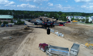
In a proof-of-concept test scanning stockpiles, NOAR inverted a BLK360 under a DJI M600. NOAR president Chad Studer says they have more development to do on this concept, but that results how promise. (Image credit – NOAR Technologies)
Another application that’s experimental at this time was to invert a BLK360 under a DJI M600. Studer said, “We wanted to see if it could handle the weight and to test the remote operation via the tablet. We tried it on a stockpile. We’ve got more work to do on stabilization, but it worked well as a proof of concept.”
The intensity differences between, for example, a roof facia board and dark roof tiles was obvious, and the images facing into the sun were a bit bleached, but no different than with any other imaging scanner I’ve tried. I could imagine doing a simple two-setup scan for, say, a wheelchair ramp project in about 15 minutes, including picking up a few visible registration points with a GNSS rover.
BEYOND BIM
After waiting months to try one of these out, I found the operations to be so blessedly simple that it almost seemed anti-climactic. But that is is a positive thing. It worked as promised, even better than I anticipated. Nightmares from decades’ past with massive scanners, registration target balls, and agonizingly slow software melted away.
Over the past year, the chatter about this new solution was that it was designed specifically for indoor-oriented markets such as BIM. I disagree. I think that, at an intro price of under $16,000 and with a ReCap Pro annual subscription at $300 (the first year is included in the purchase), this will get into the hands of many (anticipated and unanticipated) non-tradtional users, and they will cook up uses that even the developers had not foreseen. Morris, Zinck, and Frenz agreed.
This is not a consumer product, but it may fill a broad “pro-sumer” tier. Certainly architects, engineers, factory and plant managers, game makers, film makers, interior designers, perhaps even real-estate companies: these are likely candidates. And surveyors who have otherwise hesitated to enter the scanning space might find this far more versatile than at first glance (see “Surveying, Scanning, 3D, and VR”).
Blame Ridley Scott. In his 2012 space epic, “Prometheus,” there was one scene that had every surveyor and geospatial practitioner spill their popcorn: an iconic scene where the protagonists hurled a little glowing scanner orb down a darkened passage, and they watched as a 3D map formed in a holographic projection as the orb made its way through the labyrinth. We’ll pass on the aliens, but the BLK360 and ReCap Pro mobile app are getting closer in size and ease of use. We’ve got to work on the flying part though.
Image credits: Unless otherwise noted, all photos were taken by the author.
Curious about Autodesk? Check out more xyHt articles on the subject.
For more articles in this issue, click on the cover below.