
Blog

Weekly xyHt News Links: 03/15/2019
Golden Software Releases Grapher 14 with Enhanced Plotting Functions Introducing the senseFly eBee X with MicaSense RedEdge-MX, a seamless dual solution for accurate and efficient crop analysis PIX4D announces first user conference in Denver, Colorada SimActive Releases Version 8.1 with Advanced Editing Tools
Surveying & Safety
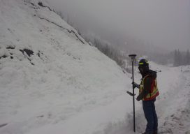
Above image: A surveying job made comfortable: Measuring a steep terrain from a safe ground location in the treacherous mountains of beautiful northern British Columbia, Canada. The importance of protecting our lifestyle. In this article, for the sake of brevity the concepts of occupational health and safety are referred to by the word “safety.” The...
Nullifying the Noise
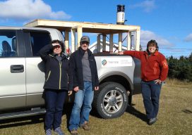
Image above: The Trifide crew of Ginette Allen and Hélène Gagné (with Herman Lavallée who rented them the truck) had to build a wooden rack and install it on the rented truck bed to provide a stable platform for the mobile mapping system. A female surveyor stays ahead of the competition and her critics by...

New (and Proposed) Rules for Drones
The FAA has imposed a significant new rule on drone identification and has proposed two new rules that could, when enacted, change the UAS operations landscape. New UAS Marking Rules While UAS identification rules have been the law of the land for some time, last month these rules have been revised. Drones weighing more than...
RFID Crazy
Above image: A Berntsen RFID reader is being used in conjunction with a smart phone. RFID-enabled infrastructure marking could become a cornerstone for a connected infrastructure management world. Imagine if all public works engineers and utility company crew chiefs were equipped with a mobile device that could easily and accurately identify every piece of infrastructure...
Weekly xyHt News Links: 03/8/2019
Microdrones and ESP Associates showcase mdLiDAR3000 workflow in 3 new videos Geo Data Explorer App – Professional GIS data visualization and analysis app. 5 Ways the World Depends on Geomatics Bentley Systems Introduces Mixed Reality App for Infrastructure Construction Projects Using Microsoft HoloLens 2 at Mobile World Congress Event Trimble Announces Next Generation Mixed-Reality Device...
Advertisement