Category Archives: Aerial/UAS

UAVs Enter the Sharing Economy
Above: A hypothetical Hangar mission plan for a city. A new platform connects UAV owners and UAV users while providing flight plans and image processing. As the UAV industry continues to grow rapidly, many companies are wondering whether they should own and operate their own UAV and, if they decide to purchase one, how they...

No Need to Buy to Fly
A startup took the idea of developing a complete sUAS workflow—hardware, software and processing services—and grew this into a premier sUAS rental/leasing service. Things move fast in the world of UAV/UAS/RPAS/drones. For example, DJI was just another UAV startup company when it was founded in 2006, and the name was not well known to the North...
The Evolution of Using Lidar
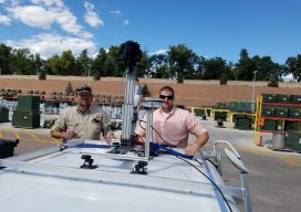
Above: Gary Rust (left) and Anthony Whitlock from Springs Utilities pose with their LiDAR USA HiWay Mapper HD. The history of a Colorado utility systematically deploying lidar technology reveals lidar’s journey as an asset. Located at the base of Pikes Peak on the front range of the Colorado Rockies, Colorado Springs Utilities is a city-owned...

Build, Buy, Rent, or Hire?
Seven years ago I was invited to attend a UAS flight course; this was an exciting proposition as the drone craze was not yet under way. In fact, the rules for operating drones in the U.S. were so in flux (as far as commercial and private drone use) that the course had to be held...

Embrace the Mesh
Above: A full 3D textured model of San Francisco produced through Skyline’s PhotoMesh 3D Reconstruction software and streamed for visualization and analytics in Skyline’s TerraExplorer. Surveyors and photogrammetrists capture reality data. But to model, manage, and provide access to massive and complex datasets—to provide your clients with true 3D mesh reality capture—you’re going to need...

Nighttime Imaging
An airport-mapping project indicates that a new set of applications may soon be served with airborne imagery collected under low-light and nighttime conditions. A geospatial services firm that specializes in building geographic information systems for airports (aka Airports GIS) faced a mapping challenge it had encountered before that’s common to airfields. Geopro Consultants, LLC, based...