Category Archives: Aerial/UAS
UAS + Lidar = “X-ray” Vision
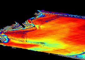
Image above: The same area as shown in the picture to the right with the ground extracted and the trees filtered out. A construction/survey project proves that UAS-borne lidar can penetrate tree cover to yield accurate ground data with improved post-processing times compared to photogrammetric solutions. I’m the VP of remote sensing at Morris P....
Point Clouds for Water Conservation
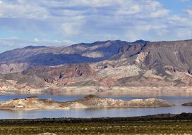
Image above: The Lake Mead region of Las Vegas, Nevada. A project to identify and quantify irrigated landscapes in Las Vegas demonstrates the advantages of using lidar to save precious natural resources. Persistent drought conditions in the western United States are dramatically reflected in the steady diminution, over the past 15 years, of Lake Mead,...
Mobile Mapping Evolves
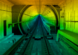
Image above: A colorized point cloud from a subway collect in Los Angeles, California. Credit: Joe Feyder, PLS, R.E.Y Engineers, INC., and John Jaramillo, Los Angeles County Metropolitan Transportation Authority. While lidar has been a standard geospatial tool for many years, the requirements of companies using it have been rapidly changing and evolving. Therefore, lidar...
Airports GIS
The history and complexities of AGIS from the expertise of a small aerial mapping company. This story started when a small group of mapping professionals were left without a company. In 2013, after their employer participated in a merger, the Seattle-based staff had their office shut down. It was an office that had been in...
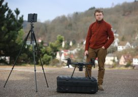
Rent a Drone
Professional drone pilot Mike Wunderlich and his freelance drone. UAVs, pilots, and startups in Germany are a perfect fit in the sharing economy. Today’s professional UAV pilots have found a niche in the construction and insurance industries for tasks that involve inspections, measurements, and image capture. At the same time, startup companies are taking advantage...
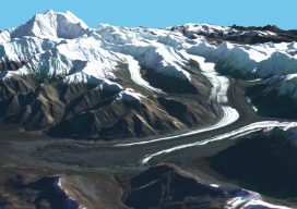
Mapping Alaska with IFSAR
A group of companies overcomes Alaska’s many mapping problems using coordinated teamwork and IFSAR. In 2008, Alaska had never been mapped at any scale to National Map Accuracy Standards, and it was the only state with no statewide orthophotos. Dewberry (a national geospatial company headquartered in Virginia) had written the National Height Modernization Study: Report...