Category Archives: Aerial/UAS

UAVs and Living Data
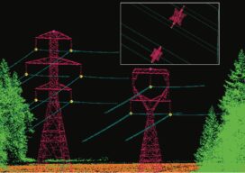
Digital twins are becoming important data for buildings and infrastructure in cities, but a utility in Chile is twinning its power corridors and adding seemingly unrelated data to identify, predict, and avoid power outages. We live in an era of combining technologies. For the past few decades, we have witnessed the most impressive movement of...
Empowering Utility Engineers to Make Informed Decisions
Aerial Services, Inc. (ASI) has been a leader in the geospatial industry for 55 years, offering turn-key solutions for lidar, orthoimagery, obliques, and geotagged 4k video supporting a multitude of applications, including above ground utilities. ASI provides rapid turnaround and high-quality mapping to assist utility engineers throughout the design, build, and inspection process. ASI’s utility...

Final Approach
The demise of a great mapping platform With the advent and adoption of new technologies, we are quick to forget about the old ways we used to do things. In the case of pocket calculators or disposable cameras is not relevant to reminisce about the past, but when the time comes to dispose of a...

Located to Mobilize Anywhere in the Continental U.S.
Midwest Aerial Photography is growing to meet our customers’ needs. Celebrating 32 years in business this year, we are capable of deploying a highly-skilled airborne data collection crew equipped with industry leading digital acquisition technology to any location in the United States and much of Canada on short notice. We take pride in our ability to...

Blowing in a New Direction
A new market is emerging for aerial mappers as investment in renewable energy grows Public and private utilities are focused on diversifying their energy portfolios after years of research and testing have improved the efficiency and reliability of alternative power generation methods. Support for the development of clean-energy options has never been stronger, creating an...

Trust Your Position with Applanix
For nearly 30 years, Applanix, A Trimble company, has offered complete and customized mobile mapping solutions while championing the technology revolution that allows pinpoint positioning in any condition. Applanix is the standard for organizations that depend on accuracy and quality, and value experienced partners. Our turnkey and OEM GNSS-Inertial solutions are designed for pinpoint accuracy,...