Category Archives: Construction/BIM

Rules of Construction
Legal Boundaries What are the Rules of Construction, and why do we need to know about them? The Rules of Construction are court-made rules that have been developed over the centuries for the interpretation of legal documents. The courts use them when the interpretation of a document is confusing, uncertain, ambiguous, or in conflict. The...

Podium Position
How the Yas Marina F1 circuit was resurfaced in just two weeks First opened in 2009, the Yas Marina Circuit in Abu Dhabi is now a key part of the Formula One (F1) season, often holding the final race for the World Constructors’ Championships and World Drivers’ Championships. The inaugural race in 2009 saw F1’s first...

xyHt Digital Magazine: December 2022
xyHt’s December issue tackles a hodgepodge of subjects, from the what’s going on in the ocean to satellites mapping from space. As always, if you don’t have a subscription to our print edition, or if someone else in the office has snaffled your copy, don’t fret, here is the digital edition. Click here or on the cover...

Repositioning GIS
The technology that will drive the next era Esri calls GIS the nervous system of the planet, a platform relevant to almost every human endeavor. It’s a way to display, manipulate, and analyze geospatial data—and that ability is ever changing and expanding across industries. GIS technology allows us to derive location intelligence from spatial and...
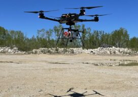
Fusing Aerial and Mobile Lidar Data
Creating accurate as-builts of a complex facilities is no longer a long-term project. When the Caltech Group was founded by two men in Calgary, Alberta, in 1990, they set out with the goal of becoming Western Canada’s go-to company for geomatics services with an eye on specializing in the oil, gas, and utility areas—those companies...
An Integrated Photogrammetry Solution
Carlson Software has innovated for the land development industry with software and hardware solutions built to work for the clients who depend on them every day. As a one-source solution, we provide CAD design software, field data collection, and laser measurement products for the surveying, civil engineering, GIS, and construction industries. Our flagship CAD program,...