Category Archives: Enviro/Ag
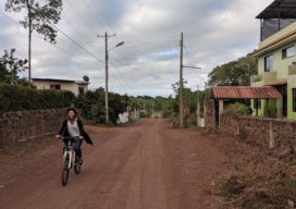
Galapagos in 360 Degrees
“Like cinders… infernal… leafless…” Charles Darwin wrote those words in his diary on September 16, 1835, after setting foot for the first time on the Galapagos. Darwin, whose scientific work in the far-flung archipelago considerably changed our understanding of how life on Earth evolves, was a keen observer of nature. And on that day, while...

Another Curveball: Coronavirus and Geospatial
Out of the blue, we’re facing another curveball. The current global concern (COVID-19, aka the Coronavirus) was generally not anticipated, and the situation changes daily. It was hoped that, by the time this is published, the situation would have calmed dramatically—but sadly it has taken a turn for the worse. Thus far disruptions have only...
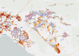
Smart Maps Guide COVID-19 Investigations and Actions
As hundreds of millions of eyes stay glued to the rising toll and reach of the novel coronavirus disease 2019 (COVID-19), map-based dashboards have become a compelling, near real-time way to monitor the outbreak. They’ve also substantiated the message that everyone must take precautions and alter daily interactions. When the World Health Organization (WHO) declared...
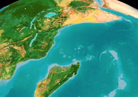
Half-Earth Day 2019
E.O. Wilson Spearheads a Global Call to Action In 2016, Edward O. Wilson, the “Father of Biodiversity,” wrote a book called Half-Earth: Our Planet’s Fight for Life. In the third part of a trilogy, after The Social Conquest of Earth and The Meaning of Human Existence, Wilson refutes our impending sixth extinction and argues the...
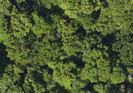
Many Sensors for a Tulip Tree Map
Above: The forests of Puerto Rico are second-growth, making for useful modeling. After hurricane deforestation in Puerto Rico, NASA scientists study forest regrowth using high-resolution, multi-sensor image data. The Biospheric Laboratory of the NASA Goddard Space Flight Center is dedicated to increasing knowledge about the Earth’s terrestrial ecosystem. One group of scientists there has been...
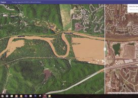
The 2017 Flooding of Missouri’s Meramec River
Missouri’s Meramec River is one of the largest free-flowing waterways in the state. With a source southwest of St. Louis, in Dent County, and the mouth at the Mississippi River in Arnold, some 20 miles south of St. Louis, its meandering 220 miles drain nearly 4,000 square miles in a watershed covering six Missouri counties....