Category Archives: Lidar/Imaging

Drones in Confinement
From warehouses to underground facilities, demand for drone inspections in GPS-denied places is rising. The new flying destination for UAVs is the great indoors.

Ingenuity Breaks New Ground for UAVs – on Mars
NASA’s Ingenuity Mars Helicopter continues to set records, flying faster and farther on Sunday, April 25, 2021 than in any tests it went through on Earth. The helicopter took off at 4:31 a.m. EDT (1:31 a.m. PDT), or 12:33 p.m. local Mars time, rising 16 feet (5 meters) – the same altitude as its second flight....
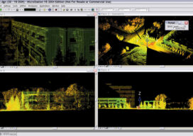
The Early Days of 3D Scanning: Part 10
In my previous article (March 2021) within my series on the Early Days of 3D Scanning, I described start-up Cyra Technologies’ significant preparations to try to secure a major, strategic vendor partner in order to take the company’s pioneering 3D scanning technology to the next big step of global commercialization.
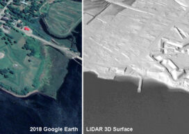
Lidar, 3D Modeling Bringing Fort Anne Back to Life
A Canadian archaeologist is using advanced mapping and visualization technologies to bring one of the earliest European settlements in North America back to life. Dr. Jonathan Fowler combined a centuries-old map with a modern 3D terrain model to portray Fort Anne and its surrounding in stunning detail – just as the Nova Scotia site looked...
The Early Days of 3D Laser Scanning: Part 9
This series of articles (monthly, starting with the June 2020 issue) gives readers behind-the-scenes insights into a small but ambitious start-up, Cyra Technologies, that was an early pioneer of 3D laser scanning technology.
Using Lidar to Strengthen Ground Control
With the maturity of aerial photogrammetry in the early 1900s in pre-war Germany, military applications, especially reconnaissance and semi-accurate 3D maps and approximate contour lines, became the norm.