Category Archives: Lidar/Imaging
Army Corps’ (JALBTCX) data improves coastal projects
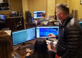
In a hotel conference room on Long Island, New York, a team of experts is processing data and information on computers. Alongside them is a large display monitor that is projecting the information. The team is the Joint Airborne Lidar Bathymetry Technical Center of Expertise (JALBTCX). “It’s a beautiful thing. On the screen they are...
The Early Days of 3D Scanning, Part 3: Cyra Unleashed
In Part 1, I described how in 1996, while working for Trimble, I first became aware of 3D laser scanning. It was being developed by Cyra Technologies Inc., a small start-up that had approached Trimble seeking a potential partnership. The jaw-dropping technology demo hooked my interest. In Part 2, I described my role in evaluating...

xyHt Weekly News Links 7/17/2020
*Click here to visit xyHt’s Virtual Trade Show* Congress Moves Against FCC’s Ligado Decision Bad Elf Flex™ Adopts the Hemisphere Phantom™ Module Honeywell Refines Navigation Revealing the World from Satellites Common Ground Alliance Launches New Expo
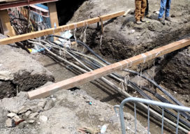
Damage to the Underground: A Stitch in Time Saves Nine
Avoiding damage to utility infrastructure could save billions. This is a summary of a white paper “Reducing Damage to Underground Utility Infrastructure during Excavation” prepared by Geoff Zeiss and Dr. Sakura Shinoaki and published by the Geospatial Information & Technology Association. Over two decades in the United States there have been more than 400 fatalities and...
Fusing Data on Doomed Ash Trees
By using fused data gathered with lidar and hyperspectral imaging, a geospatial services company helped a large utility to identify 90% of ash trees with the potential to fall into their power lines—in a timeframe that wouldn’t have been possible without the use of remote sensing. By Ian Berdie, Zach Raymer, and Mia Chen Remote-sensing...
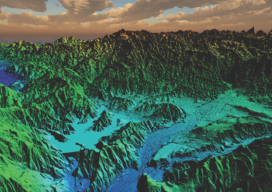
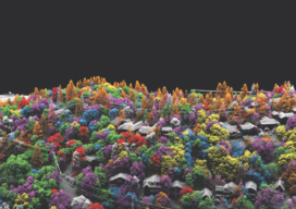
Lidar vs.Wildfires in Southern California
After the 2018 wildfires in Southern California, lidar data was collected to enable risk-mapping assessment and planning, to identify fuel-load reduction programs, and to escalate the emergency assessment of post-fire debris flow hazards. Featured image: This lidar image was taken over Lake Casitas, California. The data are clear: Natural disasters are on the rise, and...