Category Archives: Spatial IT/GIS
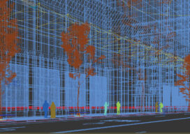
Creative Uses of 3D Modeling
The 3D data collected with laser scanners and digital cameras can be used to create digital and physical 3D models that have myriad applications—from marketing a new building to routing first responders in an emergency.
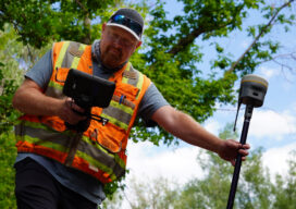
GNSS rover developments give surveyors a new edge
Chris Trevillian describes the Trimble R12i GNSS receiver with ProPoint engine with tilt compensation and calibration-free operation for flexibility, traceability and robustness

GIS Implementation in Construction: Techniques and Benefits
With Aspectum mapping software, construction companies can model objects down to the finest details and monitor project development from start to finish.

senseFly Expands its Line of Fixed-Wing Mapping Drones
A mapping drone in the $10,000 price range might sound like one of those things that’s too good to be true. And up until now, maybe it was. A Swiss company called senseFly, a global leader in fixed-wing mapping drones, has expanded its flagship eBee X drone solution with the launch of eBee Geo. The...

MAPPS 2020 Geospatial Excellence Awards
MAPPS honored members with the 2020 Geospatial Excellence Awards as part of the organization’s 14th annual Awards Presentation that took place January 26, 2021. The event was hosted by Riegl USA in conjunction with the 2021 winter meeting in Orlando, Florida. The Geospatial Excellence Awards are presented to regular and associate member firms whose entries...

Doers: Matt LaLuzerne
LaLuzerne is Strategic Growth Director, GPI Geospatial and incoming president of the Florida Region of ASPRS xyHt: How did you get started in the geospatial industry? LaLuzerne: During my undergraduate studies at the University of Florida, I focused heavily on pre-engineering courses to prepare myself for civil engineering. I would always see a small advertisement in the...