Category Archives: Spatial IT/GIS

Doers: Christoph Hinte
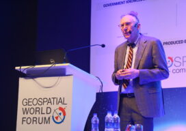
Christoph Hinte on 25 years at Intergeo Christoph Hinte is the organizer of INTERGEO, the world’s biggest annual geospatial trade fair and conference. As CEO of HINTE Expo & Conference, he has been involved in the development and strategy of INTERGEO events since in 1995. Hinte tells xyHt why this year’s event, October 13 to...
Jack Dangermond Interview Part 1: The Company
At the Esri User Conference, xyHt European editor Nicholas Duggan sat down for a one-on-one interview with Jack Dangermond, Esri founder and CEO. In Duggan’s five-part online series, running each day this week, Dangermond discusses everything from Esri’s beginning to the future of GIS. Here in Part 1 the two discuss Dangermond’s company. Nicholas Duggan:...
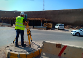
Casablanca’s Median buildings monitored during tunnel Construction
ETAFAT used the Nikon XF Total Station to monitor in real time the effects on the Medina’s aging building
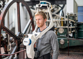
NavVis VLX: A New Take on Mobile Mapping
The NavVis VLX, the first-of-its-kind wearable mapping system designed for hands-free reality capture, including survey-grade point clouds, was introduced in May and is already having an impact in the field. The VLX captures high-quality data in even the most complex built environments. The unprecedented data quality delivered by a compact, versatile device sets a new...

Galapagos in 360 Degrees
“Like cinders… infernal… leafless…” Charles Darwin wrote those words in his diary on September 16, 1835, after setting foot for the first time on the Galapagos. Darwin, whose scientific work in the far-flung archipelago considerably changed our understanding of how life on Earth evolves, was a keen observer of nature. And on that day, while...
Citation (Jet) Needed: A Start-Up Takes Off
A wealthy investor on the other end of the line said, “Juan, I understand you are photogrammetrist and a pilot. Are you ready for a challenge? I bought six Citation jets in a government auction, and I want you to help me turn them into a modern aerial photography platform.” For those of us who...