Category Archives: Spatial IT/GIS

CAD+GIS for AEC – Finally “Going Steady”
The new release of Autodesk Civil 3D includes the Connector for ArcGIS. An Esri-Autodesk partnership, launched in 2017, takes yet another big step, and one that should make a lot of civil design professionals very happy. The sidelong glances, the flirting, the occasional dating … such has been the on-again/off-again relationship between these two giants...

Navigating Streets with No Name
Where streets have no names, confusion creates geo biz opportunities. Those of us in the business of mapping take pride in our wayfinding skills. Yet, on a recent trip to Florence, I found myself searching aimlessly for my hotel in the city’s medieval street layout. Something was definitely wrong when I ended up between numbers...

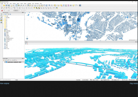
Automated City Extraction
Above: A portion of New York’s Central Park and surrounding neighborhoods, as automatically parsed into GIS data and reconstructed into 3D models by Geopipe. A new company called Geopipe builds 3D models using machine learning and AI, but with no photogrammetrists? A couple of weeks ago I found myself on a video call with a...
GIS in the Workplace – How do you ensure it is right?
If you go to the doctor’s, you can guarantee you’re seeing a professional because they’re registered. You look to get an extension done on your house, and the architect is registered (in the UK)with the Royal Institute of British Architects, or the surveyor is registered with the Royal Institute of Chartered Surveyors. So how what...

Caretographic Representations
In parts of the world where both man-made and natural catastrophes frequently occur, how are geospatial technologies being used? And for those of us whose jobs are to create maps of construction sites and other built-up areas, how can we responsibly use the same technology to monitor destruction and wreckage? I pondered these tough questions...

The Enablers of GIS
The late Roger Tomlinson is credited with being the father of GIS, but, without the commercial success of Jack and Laura Dangermond’s company, Esri, GIS would never have touched our lives the way it has. This year Esri celebrates its 50th year, though you won’t find any huge announcements from them about it as Jack...