Category Archives: Surveying

Putting the Best Foot Forward
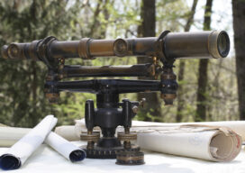
Surveyors’ Corner We are upon a solemn moment in the land surveying profession. Yes, we’ve all known for a while that this end-of-era moment was coming, but now it ends without pomp or circumstance, without the formality of an obituary, without even a memorial service. We bid adieu to a long-faithful companion that, for all...

xyHt Digital Magazine: December 2022
xyHt’s December issue tackles a hodgepodge of subjects, from the what’s going on in the ocean to satellites mapping from space. As always, if you don’t have a subscription to our print edition, or if someone else in the office has snaffled your copy, don’t fret, here is the digital edition. Click here or on the cover...
Surveying: It’s a Wonder
Sponsored by NCEES Get your end-of-year credits. Click here to learn more. Surveying is a fascinating and wonderful profession–just think about the great things that we have the opportunity to accomplish from day-to-day. We may create a new tract of land through subdivision which allows a young person to have a new home on their...
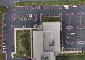
UAS and ALTA Surveys
Part 3 Precision, accuracy, and completeness are the end goals of UAS post processing, but how you get there to meet ALTA standards requires extra care. In Parts One and Two of this article in the September and October 2022 issues of xyHt we looked at the time/cost/precision proposition of using UAS for elements of...

New Digital World Needs Data
Next-generation surveyors require specialized education and training to fill the role of geospatial data specialists. Many emerging geospatial applications, such as digital twins, 3D modeling, monitoring, virtual reality, and autonomous vehicles, are based on big digital datasets. Building a 3D digital world starts with accurate data that ties to a point on the ground, so...

Sky High
UAVs deliver practical and highly technical mobile mapping Collecting imagery with uncrewed aerial vehicles (UAVs) is ideal for a variety of applications including topographic mapping, forestry ground and canopy measurements, powerline corridor mapping, Digital Terrain Model (DTM) generation, high-resolution digital imagery, and orthophoto production, along with support for a variety of other mapping needs. Historically,...