Category Archives: Surveying
ReachView 3: Native App for Reach Receivers
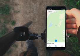
ReachView 3 is the all-new mobile app by Emlid for working with Reach RTK receivers. Familiar point collection and stakeout tools are now powered with the new user interface, coordinate system support, and ability to manage big projects. ReachView 3 is a free app available for Android and iOS devices. Coordinate Systems on Board: In ReachView...

Survey Says: Height of Mount Everest is Two Feet More
Since 1856 China and Nepal have argued over the actual height of Mount Everest, the world’s tallest mountain that sits on the border between the two countries in the Himalaya Mountains. Until today (December 8, 2020), Nepal has measured Everest at 29,029 feet. That counts the ice cap on top of the actual height of...

Digital Coast Act Becomes Law This Week
The Digital Coast Act, now approved by both chambers of Congress, will become law this week, and that is a significant step toward expanding and making accessible geospatial data to support environmental and economic development activities in the coastal regions of the United States. The bill creates a program within the National Oceanic and Atmospheric...
The Early Days of 3D Scanning, Part 6
1998: Launching 3D Laser Scanning into the Market I had the good fortune to be deeply involved with a pioneering vendor of 3D laser scanners and point cloud software. As I consider where that technology is today – a multi-billion dollar per year industry, the valuable benefits it has delivered to so many organizations and...

The Forever Chainman
A friend and colleague recently used a phrase I hadn’t heard, but it caught my attention – Forever Chainman. My initial assumption was it was intended as a negative, but that didn’t seem consistent with his prolific positivity. He didn’t disappoint. He said he used it to describe a certain type of self-starting mentality that...
PDR and the Pandemic
What continuing education will look like in the post-Covid-19 world Our Professional Development Record (PDR) hours—CPD in the UK—are a key part of the surveying and geospatial professions. Previously PDR would have involved a mixture of in-person training, in-person conferences and self-study training materials. With the Covid-19 restrictions on meeting other people face-to-face, meetings are...