Category Archives: Surveying

Jack Dangermond Interview Part 1: The Company
At the Esri User Conference, xyHt European editor Nicholas Duggan sat down for a one-on-one interview with Jack Dangermond, Esri founder and CEO. In Duggan’s five-part online series, running each day this week, Dangermond discusses everything from Esri’s beginning to the future of GIS. Here in Part 1 the two discuss Dangermond’s company. Nicholas Duggan:...

Safety Moments
Safety. It’s often at the top of an organization’s stated priorities and rightly so. It should be a top priority in every aspect of our lives. I know my own safety awareness has increased dramatically with age and experience. Whether running a chainsaw, climbing a ladder, or trout fishing a remote stream in the mountains,...
George Washington, Surveyor
If what you know about George Washington comes from your primary and secondary education— —Then John Berlau’s new book George Washington, Entrepreneur (St. Martin’s Publishing Group, $28.99) holds a treasure trove of information for you—especially for surveyors. Our US education tells us Washington was a great military leader, a diplomatic statesman, and a political pragmatist,...
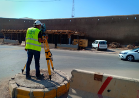
Casablanca’s Median buildings monitored during tunnel Construction
ETAFAT used the Nikon XF Total Station to monitor in real time the effects on the Medina’s aging building

Everything you ever wanted to know about Mobile Mapping
Explaining the tools and technology behind mobile mapping devices for experienced laser scanning professionals looking to make the jump to this new technology. In its short life, the market for 3D as-built documentation technology has seen considerable innovation. Among the myriad new tools to hit this market, nothing has changed the way we capture buildings...
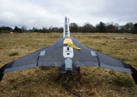
Safety First: Using Small Drones to Map Unsafe Sites
Traditionally, photogrammetry based on aerial images and stereo plotting, has been the realm of large mapping companies capable of affording the onerous ownership of planes and the high personnel cost of pilots, navigators and camera operators. The equipment used to convert the stereoscopic pairs into contour line maps cost hundreds of thousands of dollars and...