Category Archives: Surveying
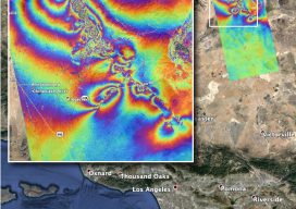
InSAR Quake “Rainbow”
This graphic, which some folks call a rippling rainbow effect, is part of the valuable post-quake analysis of the 6.4 and 7.1 magnitude earthquakes—and thousands of minor quakes—in the vicinity of Ridgecrest, California in early July 2019. This map—produced by the Advanced Rapid Imaging and Analysis (ARIA) team at NASA’s Jet Propulsion Laboratory in Pasadena,...
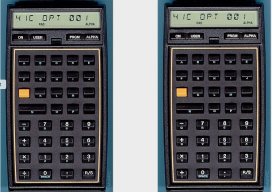
The HP-41C: A Legend Is Born
Because I tend to reminisce in my Field Notes installments from time to time, it seems fitting to include the computing workhorse of my generation, the Hewlett-Packard 41C series. It carried me through the most developmental stage of my career and will remain my favorite calculator of all time. The first HP-41C was introduced in 1979 as the first...

Fully BIM
Above: Jeffrey Truijens, BIM manager and information and process coordinator for one of the general contractors for the Pontsteiger building. Credit: Josine Voogt Fotografie. A new Amsterdam icon was developed completely with openBIM, proving that BIM can be a cornerstone for highly complex, multidisciplinary design and production coordination. Editor’s Introduction At the 2019 Geospatial World...

Passing the California PLS Exam, Part 1
Part 1: Requirements and Process Are you interested in passing the California PLS state-specific exam and becoming a California Professional Land Surveyor? If yes, then read on! I just passed my California PLS exam in May 2019 and can share my experiences with you. This article covers exam requirements and processes, the take-home exam, board-approved...
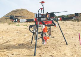
UAV Stakes Out New Ground
Above: A prototype of the Civdrone UAV preparing to drill a stake into the ground. A flying/staking robot has taken a huge step forward in automation for site layout, including road, rail, utilities, and energy applications. Working the traditional way, how many surveyor-days would it take to mark the 300,000 points needed to lay out a...
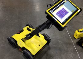
Seen at HxGN LIVE 2019
BLK2GO SLAM (simultaneous localization and mapping) lidar handhelds have become popular for BIM, as-builts, and rapid 3D modeling. The new Leica Geosystems BLK2GO shares some of the core technologies of earlier members of the BLK family (like the BLK360 scanner). What distinguishes this from many of the other SLAM handhelds is that it utilizes cameras...