Midway through a large and complex transportation project, a team of Belgian surveyors successfully adopted a new class of instrument.
Hardware and software modernization doesn’t always yield immediate benefits for enterprises, and sometimes taking a particularly big leap or risk comes at a premium in time and labor. But sometimes everything goes smoothly.
Our July 2017 feature, “Behind the Big Eye,” is on the development of a new type of surveying instrument, designed – not adapted – to add scanning, imaging, and other capabilities to a new, fully functioning total station (the Trimble SX10). Like with most things new, people have questions about its viability for ready integration into projects and workflows and what measurable benefits are realized when users put such systems to the test.
Because this system has been on the market for more than a year, we were able to speak with many users and present the following case study of forward-thinking surveyors in Belgium who adopted the system in the middle of a large and complex transportation project. They were able to fix problems they had with traditional equipment and methods without the “new equipment integration blues,” and they found additional benefits they hadn’t foreseen.
The North Line
An initiative under way for the bustling city of Antwerp, Belgium, like in many cities worldwide, is to reduce vehicular traffic, move traffic around (and under) the city center, and get more people riding bicycles, trams, rail, and buses. One of the phases is Antwerp’s new Noorderlaan tramline, or North Line, a connection to the revitalized Eilandje, or Island district. This area of docks and industrial tracts north of the city center has been undergoing a development renaissance, now hosting a mix of residences, businesses, shops, art installations, and public spaces.
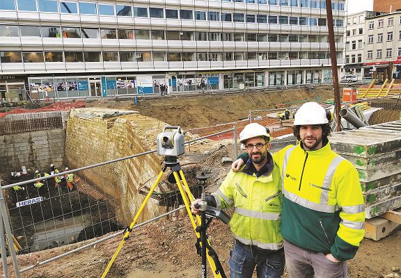
Niels Balens, land surveyor with BAM Contractors (a Belgian construction engineering prime on the project) said, “Noorderlaan will extend about six kilometers north, across the island, to a park and ride at the interchange of [a major expressway]. We built the tramline but also two bridges and some tunnels. This project had a little bit of everything.”
New construction and renovation in Antwerp is always a challenge. And to understand the scope, scale, and importance of this project, consider that Antwerp is the second-largest city in Belgium, the second-busiest port in Europe, and the seventeenth-busiest port worldwide (by cargo tonnage). Connected to the North Sea by the Westerschelde Estuary, that labyrinth of rivers and canals has made this a historically vital trade center, diverse in demographics and culture.
Noorderlaan is part of Brabo II, a multimodal transportation initiative that includes other road and rail projects. BAM Contractors is part of the tram consortium for Brabo II. It’s common for large projects to be worked by consortiums, with all disciplines of design and construction covered together, and for firms like BAM Contractors to seek to execute the many facets of a project as a consistent digital environment.
Applying New to Old
Interesting trivia from Balens: There’s an iconic statue in front of Antwerp city hall of a local hero, the mythical Roman soldier, Silvius Brabo. Legend has it that Brabo defeated a menacing giant, cut off his hand, and threw it in the river (a popular interpretation of the etymology of the name Antwerp means “hand throwing”). This series of bold initiatives to tackle the transportation challenges facing Antwerp takes its name from this local hero.
The tides of history, fortune, and rulers have woven Antwerp with a rich tapestry of infrastructure, historic buildings, bastions, port facilities, roads, and rails. BAM Contractors has experience in designing and constructing in and around existing infrastructure – and architectural antiquities. This requires accurate surveying and, increasingly, 3D modeling of existing features. They also employed conventional surveying, imaging, and scanning.
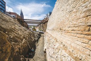
The Spanish Wall, circa 1552, had to be preserved and left exposed during construction of the tramline above it. Credit: Frederik Beyens for the City of Antwerp.
Balens said, “One section of the line went along the main road, and under this road is what is called the Spanish Wall.” Excavation revealed a section of the well-preserved bastion, one of nine built around the historic center of the city during a period of Spanish rule. The Spanish Wall (Huidevettersbastion), completed in 1552, lies just below the surface, but preservation efforts have dictated that it will remain exposed with an observation walkway overhead.
“The wall is being incorporated into the tram project.” Balens said. “We measured the wall and added this to the survey so the engineers could complete the design, a design that would not [negatively impact] the wall.”
The Spanish Wall was not the only historic or existing structure that BAM Contractors had to incorporate into the design, and the surveying of these complex elements was one of the areas where the new class of surveying instrument they adopted shined.
The new tramline begins at the Opera Tram Station in central Antwerp. Built in the 1970s, the station has three levels in anticipation of line expansion. All new design and construction would need to interface with the existing elements of the station.
“The design was difficult because we started with old paper plans. It was critical that we measure [as-built] the existing areas to give to the engineers,” Balens said. “We measured before the design and during construction. There were scans done by another team, and this was a bit of problem, so we have done new measurements and scans with the SX10.”
The problem with the original scans, according to Balens, is that they were not properly registered and were very large and difficult to work with. Balens’ team acquired an SX10 after construction had started but were able to incorporate the new instrument into their workflow, solve the problem of the unwieldy legacy scans, and support the engineers with new 3D data.
Adapting Mid-project
The Trimble SX10 was first released in November 2016. BAM Contractors was an early adopter, recognizing a potential to solve engineering and surveying conundrums they commonly encounter. For the team, this was truly a new class of surveying instrument, a bridge between the worlds of precise terrestrial surveying and high-definition 3D scanning.
Scanning sections of the Opera Station was one of the first tasks for their new instrument. The contrasts between the old and new solutions and methods were particularly striking as they made the changes mid-project.
“We had to do a lot of small scans, on demand from the engineers, for different parts of the station”, said fellow surveyor from BAM Contractor, Johan Egerickx. “Opera station has existing car tunnels to connect with parking, and there are to be five new car tunnels for parking and to pass traffic through the area. The second level is an existing tram line, and [Noorderlaan] is on the third level; we built a tunnel from there to the surface, about 400 meters.”
The older scans were not usable by the engineers, as Egerickx explained. He noted, “The engineers would ask for new measurements in different parts of the station, and we could go there, set up the SX10, and perform a scan that was completely registered, in resection which is what we did. And we can deliver this to the engineers immediately.”
With the project control traverses and conventional surveying data collection being performed on the same instrument as the scanning, there were no problems of proper registration of scans and images. The benefits of a “single field instrument environment” also reduced subsequent steps in the office software. The team has also used the SX10 on the Spanish Wall section and will on additional car tunnels.
Was it difficult to adapt to this new instrument? “We had some concerns before we started using it”, Egerickx said. “There was no eyepiece, no active tracking, and we had not worked on a tablet before with our total stations. But operating it is similar to operating our total stations, and finding yourself and the prism on the tablet view [operating on the rod robotically] is very fast, so after a while, we didn’t miss the active tracking. During layout, the tablet balances well on the rod. It was not a problem.”
And having a larger screen to work with? Egerickx responded, “Now when I use one of our old total stations and the [small screen of the data collector], I find myself missing the tablet.”
Is the scanner functionality adequate? “We don’t mind the ten minutes for the [full dome] scan,” Balens said. “Our experience with scanners is that they create millions of points and large files. Sure, it looks like a photo, but this is overkill. Our engineers do not want points every millimeter; they just need enough measurements to add existing structures to the design.”
Balens added, “We [often] have to decimate any scan to what the engineers wanted to work within [Autodesk] Civil 3D [design software].”
Adapting new equipment into their workflow was not difficult; BAM Contractors surveyors had already been using a lot of Trimble hardware and software, like Trimble Access field software with their total stations and GNSS rovers. They also use Trimble Business Center software in the office, which has modules for handling the panoramic images and scans from the new instrument and integrating this with all other survey data. This tight coupling of precise instrumentation and software has been integrated into many of BAM Contractors design-build projects and especially on Noorderlaan.
Complete Digital Environment
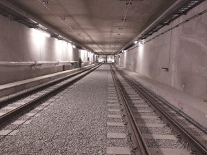
After the completion of the south-western tunnel connecting the Frankrijklei with the underground opera station and car park, scanning results were used to check the tunnel for tram clearance and a quality check of how well the concrete structures compare to the design. The electricity lines were also measured and checked. Credit: Noorderlijn.
The Royal BAM Group is a prominent international engineering and construction firm based in the Netherlands; its many subsidiaries specialize in the road, rail, marine, and more. The idea behind the Belgian subsidiary BAM Contractors is, as Balens explained, “Do a little bit of everything,” focusing on large-scale, multi-discipline projects.
Noorderlaan encompasses road, rail, tunnels, and bridges; BAM contractors and their partners in the project encompass the entire life cycle, from design through construction and commissioning (handing the system over to the client). This requires surveying expertise and integrated tools for all phases.
“We started with GNSS survey control using the Belgian VRS network [FLEPOS],” Egerickx said. “We used to set up a base a lot, but now we use the network all the time. It’s great, and free, and we even use it on [machine control]. Then we do a control traverse and digital level [loops] with our total stations and DiNi levels.”
“This project had another first for us,” Egerickx said. “We did no staking for earthworks. Our [sub]contractor Aertssen used [machine control] for all the earthworks, also Trimble on most of their equipment for this project. This equipment mainly uses GNSS, but around buildings where there’s not much sky, the small excavators are [controlled] by total stations. In past projects, when there were small earthworks or rework during construction, we would set stakes, but Aertssen now only wants a digital model. This all happens much faster now.”
Dewatering must be done for work on the multiple tunnels for the project (the subsurface water is pumped out), which can result in subsidence of buildings.
“We put reference marks on the buildings to monitor for any sinking and do weekly level [loops] with our DiNi levels,” Egerickx said.
One of the two bridges in the project, known as the London Bridge, is a replacement for an older bridge. In addition to design and construction surveying for the bridge, Egerickx performs weekly monitoring.
“We put a permanent bolt on a [stable rock outcrop] near the bridge. There are six prisms on the bridge. Each week I mount the total station on the bolt, and the monitoring [module] in Trimble Access on the TSC3 [data controller] does the monitoring [rounds] automatically.”
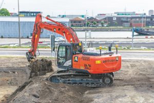
The earthworks contractor Aertssen asked BAM Contractors only for digital files for machine control; with almost no staking requested, the team is closer to the goal of a complete digital environment. Credit: Aertssen.
Balens and Egerickx openly express their satisfaction with this new solution – and relief that their risk-taking has paid off.
One of the key takeaways from working with these two talented surveyors on this article is that they represent the current wave of young surveyors, skilled in fundamentals but eager to implement and try new ideas. These attributes are essential to meeting the growing global demands for infrastructure development and modernization.
This project brought them closer to the goal of a complete digital environment, and it was their first with a total adoption of machine control for earthworks and integration of this new instrument into their workflows: a new bridge between their conventional surveying and 3D field data collection.