Trimble’s Bryn Fosburgh Talks BIM
Editor’s note: From a distance, BIM looks like it would present quite a challenge to implement: how to affect smooth and efficient workflows encompassing diverse and complex elements. As surveyors and other geospatial practitioners try to get their arms around the subject and to define their roles in such processes, we hear a lot of the same questions and concerns, chiefly how do all of the parts work together and how are their skills and the tools of their profession integrated? We asked Trimble’s senior VP Bryn Fosburgh (well-known and respected in the surveying and geospatial communities) to provide an overview of BIM in this context, and more specifically what kinds of tools and solutions a company like Trimble provides to enable this integration.Since my early surveying days, I’ve seen amazing developments in tools and solutions. By far the biggest impact has come in how integrated solutions can transform the way people work. It’s an exciting time—and when it comes to BIM, things will only get more exciting.
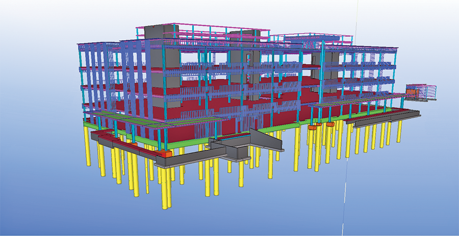
This pre-construction model of the new Trimble facility shows above- and below-ground structural elements.
The term BIM, which comes from “Building Information Modeling,” can be a little misleading. It’s not just about buildings; BIM is the process that enables the efficient and quality design, construction, and operation of a structure such as a building, bridge, or highway. The core BIM principles and concepts, which were pioneered for the construction and management of buildings, are being applied in heavy civil construction, utilities, energy, and more.
Today, BIM is an emerging technology that is transforming the way we build. The use of three-dimensional models and real-time management of processes and workflows delivers the efficiency that today’s clients demand.
Modern BIM is the combination of technologies (in the field, office, and cloud), people, and processes that support the development and exchange of information for building construction and operations. Just as each project is unique, the concept and application of BIM varies with the needs of the project’s stakeholders: owners, contractors, architects, designers, engineers, project managers, and suppliers. Each of these constituents plays a specific role in the overall project. They often use different skills and technologies to complete their tasks and deliverables while leveraging the collaboration and sharing that lie at the core of effective BIM processes.
Geospatial information plays a role at multiple stages throughout the BIM processes. In order to provide key data and services, geospatial professionals must be adept at the capture, analysis, and delivery of information using multiple technologies and formats. In doing so, they use their core capabilities to produce and manage a single, comprehensive reference frame for a project.
Points, Point Clouds, and 3D Models
The evolution of BIM has benefited from advancements in GNSS, scanning, and optical measurements. Fieldwork is faster, simpler, and more efficient. Most work involves multiple tools and solutions. Having those elements work in an integrated manner (such as blending GNSS with an imaging rover) is just the first step.
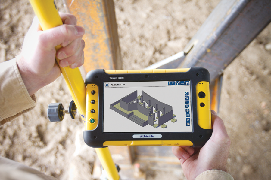
In-field displays of 3D models support layout, inspection, and quality control.
Field systems have expanded to leverage new techniques in imaging and connectivity. One of the most important recent developments, georeferenced imagery, enables surveyors to capture large amounts of data and significantly reduce time in the field.
The work to capture high-resolution georeferenced imagery can be part of the conventional survey workflow, enabling integration of photos with survey points and direct measurement using field-captured images. Increasing connectivity and wireless internet access enables field crews to sync their data with office servers or via the cloud. In the office, technicians can use photogrammetry to create individual 3D points and even point clouds from photos and panoramas.
Information derived from field survey data plays an essential role in early-stage BIM processes. Points, linework, surface models, and images can be visualized in two or three dimensions and delivered to specialized software for architecture, building design, and engineering. Once the designs are completed, design data, work orders, inspection reports, and design changes can be delivered directly to field crews and project teams.
The combination of imaging and connectivity can be especially valuable during construction. When an issue arises onsite, crews can collect positions and images to provide detailed information on the problem and surrounding context. By using cloud-based geospatial information management services, design teams can access the data immediately and develop solutions based on current and accurate visual and empirical information. Models and designs can be revised and reviewed as needed; updated information is then sent directly to the site. Revised grading plans can even be loaded wirelessly onto machine guidance systems.
High Speed and High Density
In the next few years, a high percentage of U.S. building projects will be the renovation or repurposing of existing structures. Many of these projects will use BIM and will need dense, detailed information about the existing buildings. Geospatial professionals are nicely positioned to provide this information by using 3D scanning (lidar), photogrammetry, and conventional surveying techniques.
Lidar technologies have opened new doors for many geospatial applications. For BIM, point clouds enable precise modeling of existing terrain and structures. Aerial scanning produces point clouds and meshes for use in digital terrain models (DTM), land-use analyses, and other large-scale mapping applications.
Point clouds produced by terrestrial mobile and stationary scanning have a growing number of uses, including GIS and asset management, preservation and restoration of historic structures, industrial surveys, mining, and terrain modeling.
As lidar technology continues to evolve, the focus has shifted from gathering data to efficiently managing, analyzing, and utilizing the large 3D datasets. Well-defined workflows enable stakeholders to visualize the point clouds and develop computer-aided design (CAD) models for use in an enterprise’s chain of analysis, design, and decision-making.
While some users prefer to work directly with 3D point clouds, the size and complexity of the datasets present challenges in handling the points and extracting useful information. Many users rely on service providers to develop 3D models of the terrain, structures, and objects captured in a point cloud. Models can be transferred to architectural designers for development of basic concepts, including the placement of a building onto its site.
Final site design typically takes place in specialized civil engineering software. From there, design data returns to the field for stakeout or to be loaded into systems for automated control of grading and excavation machines.
Today, visualization technologies for BIM are moving beyond point clouds and 3D CAD models. New tools for augmented reality extend 3D models from 2D displays into virtual space. Designers and stakeholders can interact with the details of their structures, combining real-world data with design information in a virtual 3D project site. The result is improved collaboration and management for complex, multi-phase projects.
UAS Meets BIM
Geospatial professionals now have access to a sleek new set of tools to support BIM processes. Unmanned aircraft systems (UAS) have the potential to be a disruptive technology of a magnitude similar to what the geospatial industry experienced with GNSS and robotic total stations.
Images from UAS can provide information essential to BIM processes, including data on terrain, access, utilities, and surrounding conditions, as well as information on work progress and quality. UAS can deploy quickly to collect large amounts of data in a short time and at lower cost than piloted aircraft. And data from UAS can quickly be analyzed and delivered to the people and processes that need the information.
The ability to quickly collect and process data into actionable information makes UAS an attractive option for the construction and operational phases of large projects. In addition to preconstruction surveys, UAS is well suited for large construction sites as well as applications such as agriculture, open pit mining, and landfills, where timely aerial data can be used for volume computations, progress monitoring, and materials management.
Fitting It All Together
Terrain models and site designs are typically developed using geodetic or survey coordinates that relate the site to the ground and properties around it. A site plan showing the building, grading, drainage, and utility connections is often developed using the survey coordinates. By contrast, buildings are designed in 2D or 3D CAD—and their coordinate systems generally relate only to the building itself.
3D building modeling connects the two coordinate systems and can create a project coordinate system. The approach enables contractors and tradespeople to work in familiar systems while ensuring accurate connection of the building to the site.
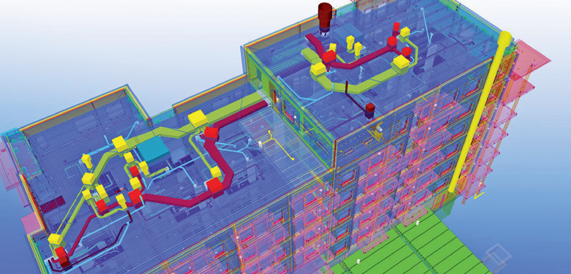
As the design process unfolds, designers produce models for a building’s structure, MEP (mechanical, electrical, and plumbing systems), and other components. Using BIM tools, models are combined and analyzed for conflicts or discontinuities. Advanced solutions help designers create high-performance buildings by reducing energy and water consumption while optimizing sustainability and capital efficiency.
In addition to design and building data, BIM processes generate new information that adds significant value to the Design-Build-Operate (DBO) lifecycle. For example, systems can create data sheets and maintenance information that will help the owners and users during the lifetime of the structure.
Modern building information modeling enables geospatial professionals to integrate multiple technologies to optimize work processes in the building and heavy civil industries. By blending geospatial data with systems for communication, analysis, and information exchange, BIM provides new levels of efficiency and flexibility throughout the building lifecycle.
For surveyors and other geospatial professionals, the best opportunity in BIM can come through developing a deeper knowledge of building construction. By understanding your clients’ needs and workflows, you can weave your organization into the technologies, processes and people that produce a successful project.
Trimble has put many of our tools and solutions to the test on our own campus in Colorado. The project repeatedly showed that getting the right information to the right person—at the right time—provides benefits that can cascade far beyond the original users. Read more about it here: Buildings.trimble.com.