Leica’s “iCon build” solves a common layout automation conundrum for vertical construction firms, large and small.
Editor’s note: The benefits of automation for vertical construction are not limited to projects that have implemented full-on, single-environment BIM. Many firms and projects can now use a realistic and practical mix of old and new workflows and technologies during this transition in the construction industry.
At CONEXPO 2017, we were given a demonstration of one tool in the new wave of automated layout solutions for vertical construction that can work in a fully integrated, model-based workflow but also provides tools for models developed ad hoc or in the field. Here are the details.
The adoption of hand-held devices and field software has grown exponentially in the past few years throughout the architecture, engineering, and construction (AEC) industry. Yet, often, small contractors are still handed paper blueprints of all sizes and don’t have up-to-date as-builts when starting improvement or re-build projects.
Until recently, entering specs from a paper blueprint into layout software or editing a digital layout required a trip back to the office or, at a minimum, a call to someone there who could work on the model, with the hope that nothing would be lost in translation. To the extent that it made it possible to do this work in the field, construction or mechanical, electrical, and plumbing construction layout software required significant surveying knowledge.
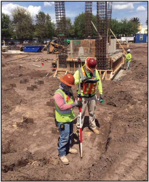
Jesus Gonzalez works with a robot in the pile caps at Adventist Health Systems Building 3. Credit: Jacob Roell.
To address these challenges, the Leica’s iCON build (that “b” is intentionally lowercase) software simplifies layout in the field and is aimed at construction layout professionals who are not schooled in surveying or layout.
“We wanted to provide a solution that was available for and usable by everybody who is involved in the construction process, not just the professional surveyors,” says Carl Singleton, Leica Geosystems’ product marketing manager for building and construction, NAFTA.
The Leica iCON build customized construction software is part of the Leica iCON construction line of products, which also consists of high-end GPS receivers, manual total stations, robotic instruments, and field controllers.
“In the vertical construction market in which we specialize, the Leica iCON robots are used, by and large, more than GPS,” says Singleton.
Often, he points out, GPS is not an option in vertical construction, because a deck above precludes a clear view of the sky or because GPS is not accurate enough for the required precision layout. Manual total stations can get the job done, but slowly, making robotic total stations the devices of choice.
“Robotic layout gives you immediate, live, continuous data, whereas manual instruments only give static, individual snapshots of data at a time. As a result, robotic total stations are three to five times more efficient than manual instruments.”
Workflows
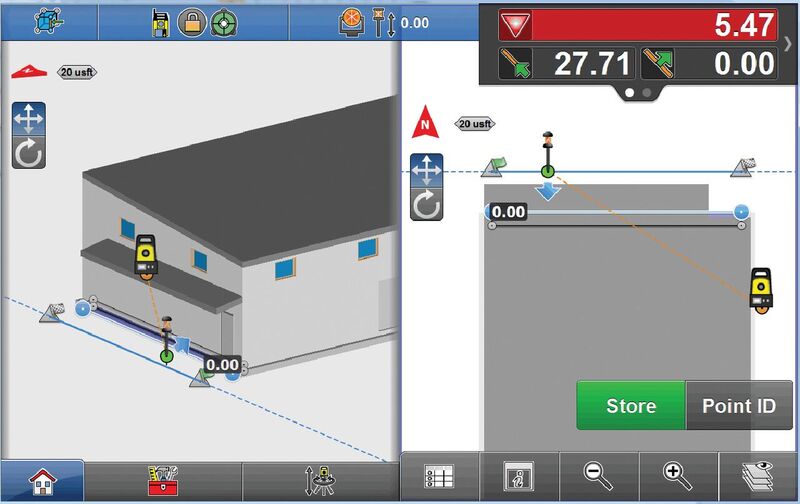
A vertical construction workflow typically starts in a highly coordinated and fully rendered Revit model. Leica iCON build software allows users to import that model, orient a robotic total station, and lay out different objects in the field.
“We can select the corners and edges of slabs, gridlines, column lines–basically anything that was in the office model, is now in the field software. We can select any object and immediately go to work laying out,” Singleton explains. Users can store that information, bring it back into the model, and identify any discrepancies that need to be addressed between what was designed in the model and what was placed in the field.
“That is a start-to-finish approach.”
In another kind of workflow, a contractor adds to a model missing information that is required for making improvements. “They get an orientation with the robot and start collecting data to verify what is there. Then they bring that as-built data back into the model,” says Singleton. “With the accurate information now in their model they can continue designing the new space.”
For contractors who are given paper blueprints and told to go lay them out, Leica iCON software includes a sketching application that is a like mini-version of many CAD packages.
“It has many CAD-like features that allow you to simply sketch a footprint of a building from scratch and then do all kinds of edits and alterations.” says Singleton. “You can give yourself the three-foot offset because you need to excavate a pit. You can make additions as you go.”
If the architect changes something halfway through the project, maybe decides that the back wall will be curved rather than straight, the sketching app enables the contractor to insert that element on the fly. It also makes it easy to divide segments into any number of smaller segments of exactly the same length. iCON build software also allows the contractor to make sure the building is square by simply storing a point on each corner, then virtually checking the distance with two taps on the screen to verify that the diagonals match.
Small contractors are still handed paper blueprints of all sizes and don’t have up-to-date as-builts when starting improvement or re-build projects.
To double check the control onsite, contractors can use the sketching app to do a line-line intersection of where they discover their control point to be on a deck.
“They might have thought that it was gridline A1, but then get out there and discover that their control line was actually an offset of C7 instead,” says Singleton. “In some other software, that can be a problem. With the Leica iCON build software, you simply do a line-line intersection for C7, offset it 5 ft each way, and–boom!–you’ve got yourself a control point in your field software.”
In Construction Language
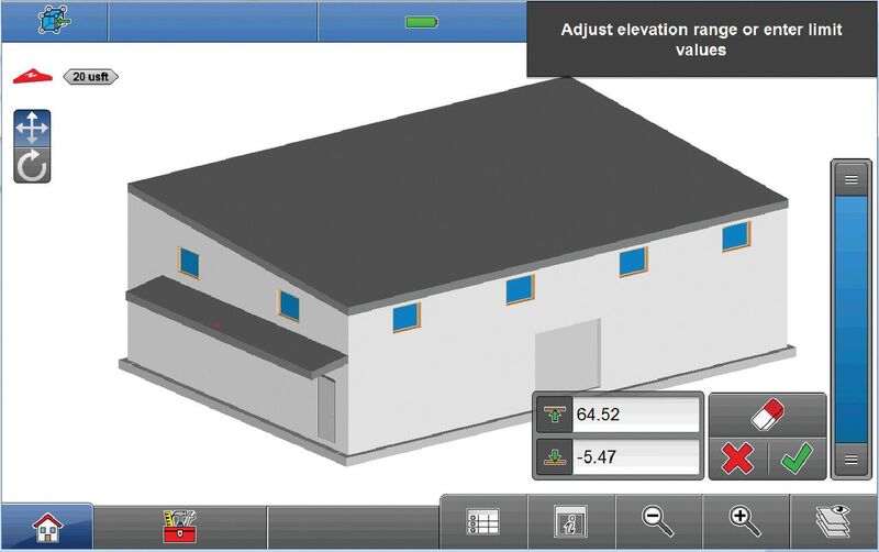
The Zlider Bar elevation filter allows you to “slice” the fully rendered model at any elevation.
The biggest difference between the Leica iCON line of construction products and previous Leica products, according to Singleton, is the fact that iCON was not originally written for surveyors and then adapted for use by contractors.
“This software was written by experienced construction professionals, for construction professionals and layout people alike. It speaks a contractor’s language.”
Version 3.5 of the Leica iCON build software, which Leica Geosystems announced at the CONEXPO-CON/AGG trade show in March, includes a new application called layout object. It allows users to import a fully rendered model from Revit, or any other authoring software, and select objects from the model as described above. If you then tap on, say, the floor, the program selects the whole slab, showing its thickness and all of its corners. You can select one of the edges, with a start point and an end point, and lay it out. You can also build formwork by offsetting the edge (line) and then laying it out.
“In order to do anything close to this in the past,” Singleton points out, “it has always taken at least two files: a DXF file with 2D line work and an ASCII file (txt or csv) full of points that get laid on top of that 2D DXF. This new layout objects app consists of just one file, the fully rendered model. You get all the metadata that is in the authoring office software, and it carries through to the object.” Another new feature of the v3.5 release is the elevation filter (Zlider Bar). This tool allows the user to “slice”the fully rendered model in the field software at any elevation needed.
“It’s basically the equivalent to a section box tool in office modeling software,” explains Singleton. “You might take an entire 10-story model into the iCON build field software, but you may only be working on the 3rd floor for the next several weeks. With the elevation filter, you can ‘cut off’ floors 0 through 2 and floors 4 through 10 so that you’re looking at only the 3rd floor, still as a fully rendered model. Select interior columns, the slab, interior floor penetrations or hanger locations00whatever is required for layout on the 3rd floor is now at your fingertips.”
Field Training
Charles Curtis is a virtual design and construction (VDC) field engineer at Brasfield & Gorrie, General Contractors, where he’s worked for about 12 years. He is a liaison between office staff and field staff.
“I take the new iCON system out to the engineers in the field, train them on its use and on new software, get them up to speed with Revit and Navisworks, then let them go free,” he says. “I really enjoy working on hospitals, the larger the better. Taking all that information and putting it out into the field is gratifying for me. We are really interested in some of the more complex projects.”
Part of Curtis’ role as a VDC field engineer is to implement a process that carries the information from the pre-construction phase, where it started, through construction, where it is used, and then back as an as-built model.
Curtis says, “We were able to take the BIM information from pre-construction through construction and have a two-way flow of information back once we actually installed all the systems.”
Why did Brasfield & Gorrie adopt Leica iCON? Curtis says,
“We decided that iCON had the least amount of learning curve for our field engineers who then used Leica equipment. They gave us all the tools that we needed to accomplish our goals.”
The different apps that are available with Leica iCON–such as the cut/fill analysis–have enabled Brasfield & Gorrie to “dive pretty deep into as-builts,” says Curtis. The other big advantage of iCON build, he adds, is the ability to do the layout itself in the field. Back in the day when they used hand-held devices with small screens and single-color displays as data collectors, it was sometimes difficult for Curtis and his colleagues to pick the specific element point or line that they wanted.
“The 10.1″ screen on the Panasonic FZ-G1 tablet allows us to see much better what we are trying to pick. We don’t have to zoom in as much; we can still see the context of the area around us. In some congested places, it is hard to realize what you are actually grabbing. You could end up laying out a point or a line that you did not really need and then you would have to go back and fix it later.”
In situations where they don’t have a point or a line that they need to lay out–or where it’s at a different angle from some of the other objects so that they are not able to just offset it–the sketching tool allows contractors to easily locate new elements that they can use as starting points for the layout, Curtis explains.
“If we get into a situation where we don’t necessarily have a control point but we have an offset from another control line, then we can sketch a new point to use as a new control point.”
When Curtis and his colleagues used Carlson software, they used its COGO tool.
“Sketching is basically the same as the COGO tools,” Curtis says, “except that [the Leica iCON build] user interface is a little bit easier to deal with. You don’t have to necessarily punch in an azimuth every time. It has a wheel that you can spin around pretty quickly and easily to orient the direction in which you want to put a new point or line. There are several little tools to make using iCON build quick and easy. [It] has made everything a lot more efficient and accurate.”
The transition from paper to digital in the field continues and will probably have a “long right tail” (as in a skewed statistical distribution), or in other words, a moderate but steady adoption rate across the industry. We may still use paper for many years. Leica’s iCON build software is broadening the user base of field layout software by making it much more accessible to construction professionals with little or no formal training in surveying and layout. Good call-out: Small contractors are still often handed paper blueprints of all sizes and often don’t have up-to-date as-builts when starting improvement or re-build projects.
Increasing Efficiency through Cloud-based Construction Management
In a typical construction project, establishing accountability can be difficult due to inaccurate base planning documents, lack of pre-construction coordination, ineffective communication between the field and office, and other challenges. As a result, schedule delays and budget overruns are common.
HxGN SMART Build, developed by Leica Geosystems’ parent company Hexagon, is a cloud-based construction management platform designed to overcome these problems by giving project teams access to the real-time information they need to report deviations and submit completion updates.
There are a lot of buzz- words here, so let’s explain the terminology. “Think of it as a connectivity layer,” says Matthew E. Wheelis, Leica Geosystems segment manager for building construction in North America. It enables users to “put together work packages that contain layout information and are connected to crew information, schedule, cost, and resource information.”
He thinks of HxGN SMART Build as being “about how Hexagon is moving into this period in which information is all connected together, from beginning to end,” he says. “The connection to the Leica iCON robots, to layout information, as well as to reality capture information from laser scanners is an important part of that vision.”