A Danish company builds a successful monitoring business by leveraging technology and expertise.
By John Stenmark, LS
Newton’s laws of motion tell us that nothing moves if it isn’t pushed or pulled. That concept is behind the success of LE34, a Copenhagen-based surveying company that has built a business strategy around structural monitoring for a variety of construction applications.
Instead of simply measuring positions over time, LE34 combines multiple technologies to measure both motion and the forces that cause it. Referred to internally as “blending millimeters with kilonewtons,” the approach enables the company to help its clients understand a structure’s behavior and make timely, informed decisions. It’s become a successful and sustainable business.
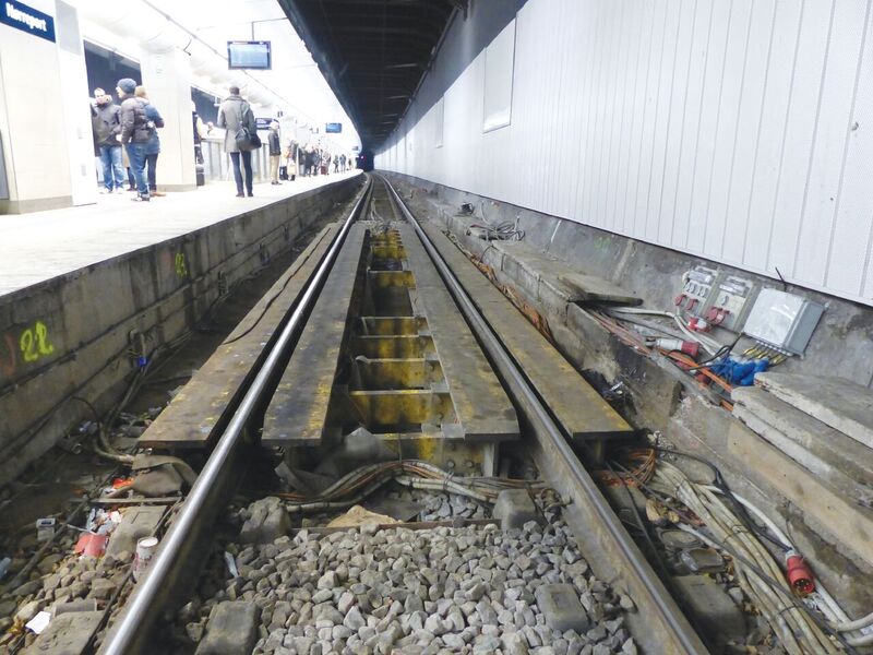
LE34 monitored tracks during construction of a tunnel passing above the underground Nørreport station.
The Business of Monitoring
With more than 300 people on staff, LE34 is a multi-faceted surveying company. While the bulk of its business is in land development and property surveys, the company for years has provided technical or engineering surveying for construction and infrastructure. According to Søren Nørmølle, a company partner and head of monitoring, technical surveying requires higher accuracy, tight documentation and more-demanding analyses of the measurements. It’s not unusual to work at the millimeter or sub-millimeter level. LE34’s work in monitoring started more than two decades ago with the construction of the Great Belt Fixed Link in the 1990s. The largest construction project in Danish history, the Link created a series of tunnels and bridges as part of the effort to connect road and rail traffic between mainland Europe and Sweden.
The project centerpiece is the Great Belt Bridge, a 1.6-km (1-mi) long suspension bridge that opened to traffic in 1998. LE34 provided engineering surveying and monitoring during construction and continues to supply monitoring data to bridge operators. According to Nørmølle, the experience gained through work on the Great Belt Bridge helped LE34 develop its capabilities to handle the pressure-filled and exacting work of precise engineering surveys, including monitoring.
Denmark’s active tunnel-construction market provided an additional source of business and experience for LE34. Many tunnels are constructed using the New Austrian Tunneling Method (NATM) that arose in the 1960s as a more-efficient approach to tunnel construction. It’s a “design as you build” technique that uses observed conditions to update and refine designs as a tunnel is constructed. The approach relies heavily on monitoring technologies to provide information on the behavior of the rock mass and tunnel lining.
“NATM eliminated the need to design for unknown conditions,” Nørmølle explained. “You react to conditions as they are encountered and redesign as construction proceeds using actual data. ItÕs been proven to be an effective approach that helps reduce construction costs.”
A third part of LE34’s monitoring strategy comes from construction activities in developed areas. The work is driven by increasing activity in new and rehabbed structures and infrastructure as well as urban infill. Nørmølle said they often pursue monitoring for large projects in developed areas where construction contracts call for monitoring to protect existing structures and prevent disruption to transit and public activities.
The Positioning Consultant
LE34 services begin long before any measurements take place. Working closely with clients and their consultants (including engineering, geotechnical, and soil specialists), LE34 examines a project and provides advice on what and where to monitor. The team considers factors such as location, risk, and value when developing monitoring strategies for surrounding structures. The planning includes identifying the type and placement of sensors to use, monitoring intervals, analyses, and alert requirements.
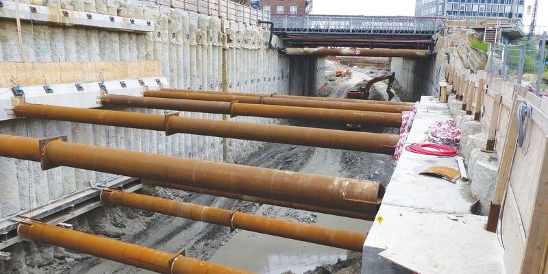
One example is the Nordhavnsvej, a 1-km (0.6-mi) cut-and-cover tunnel project in Copenhagen. The tunnel passes beneath existing major roads and railways, so traffic disruptions would not be tolerated. Additionally, the proximity of large buildings called for additional measurements.
“The exciting thing about this project is that we have this combination of geotechnical sensors and geometric sensors,” Nørmølle said. “We have the building sensors inside the work areas to monitor the actual forces that are operating in the construction zone. We also have positioning (geometric) sensors that are monitoring the environment and the outcome of the forces, i.e., the movement resulting from these forces. So we have a double system that covers the internal forces and any resulting subsidence.”
The project contractor wanted to have a single point of contact for monitoring, and–as a local company–LE34 believed it should be the logical point.
“When talking business strategy, it’s really not anything awesome,” Nørmølle said. “Simply by being there and being ready to solve the challenges, we were able to assist and advise the constructor and the project owner.”
LE34 approached the Nordhavnsvej with a variety of technologies. For positioning they installed 11 Trimble S9 total stations that monitor nearly 280 prism targets in and around the construction zone. The instruments are equipped with Trimble VISION technology, which LE34 technicians use to look through an instrument’s telescope to spot obstructions or issues that could prevent measurements to a prism.
To monitor forces on the project, they used a battery of more than 300 strain gauges, load cells, and inclinometer probes. Ten weather stations provide meteorological data. The system is managed using Trimble 4D Control software (T4D) running on a computer at LE34’s office.
In addition to remotely controlling the total stations, the monitoring software collects data from the geotechnical and meteorological sensors. LE34 uses the T4D virtual sensor functions to integrate the data in real time for reporting and analysis. Nørmølle described another project to illustrate how LE34 blends sensor technologies for monitoring. The Nørreport project created a short pedestrian tunnel to connect two underground transport systems in an area already perforated with rail and transit tunnels.
“In all, we had two Metro tunnels, a couple of train tunnels above, and some very old building foundations right next to the excavation and tunneling area,” he said. “The new tunnel was going to just sneak on top of the Metro tubes.”
As the tunnel wove its way through the congested area, LE34 installed total stations above ground and in the Metro tunnels to watch for any subsidence.
The Nørreport project came with another problem: it lies in an old swamp. The ground is quite soft and there’s a lot of pressure from the structures above the tunnel. LE34 used extensometers in the bottom of the excavations to check for any movement or uplift from the soft soils. One project contractor used freezing to stabilize the ground during construction.
“We were monitoring the temperatures,” Nørmølle said. “When it reached minus 18°C (0°F), the ground gets solid and starts to behave like rocks. As it froze, the ground expanded, which could affect the railroad in the tunnel above and cause the tracks to lift. So when some parts were getting cold we had to keep other parts warm.”
The LE34 teams used T4D software to manage data from the total stations, thermal sensors, and extensometers to develop precise information needed to manage the work. The integrated data made it easier for them to analyze the correlation between the freezing and uplift.
Additional monitoring came into play using extensometers and surface leveling to measure the effects and behavior of the soft ground. There were even a few incidents where more concrete than expected was poured into boreholes, indicating the likely presence of underground sinkhole structures.

The excavation on the Nordhavensvej jobsite.
Small Projects Produce Big Results
LE34 doesn’t focus exclusively on large projects. The company can apply its knowledge and flexibility to smaller jobs as well, which provide profitable work and good market exposure.
Nørmølle described work to construct a “climate tunnel,” a new tunnel that would enable Copenhagen’s sewer system to better cope with heavy rain. The tunnel is 900 m (3,000 ft) long, 3 m (10 ft) in diameter, and runs from the center of the city to the harbor. The tunnel is roughly 23 m (75 ft) below the surface and was constructed using a micro tunneling machine.
LE34 provided monitoring on eight active railroad tracks above the tunnel. The railway would not accept any kind of subsidence or disturbance that would reduce the speed of trains on the tracks. The monitoring work included two S9 total stations secured in small steel houses to protect them from debris from the trains and approximately 300 prisms mounted on the tracks. Like its other monitoring projects, LE34 controlled the measurements and analyses using T4D software.
In addition to rigorous measurements and analysis, LE34 used the system to demonstrate to its clients how automated monitoring can reduce project costs. The original monitoring plan called for manual leveling every night on the eight tracks.
“With a four-hour work window, this would take roughly six people, plus the safety guards.” Nørmølle said. “It would be almost a 10-person operation and, because it’s nighttime work, it was really expensive. Instead, in a couple of nights we installed a pair of total stations, placed the prisms, and then had the system running for three months. At the end of the work we spent a couple more nights removing the prisms. By using the automated system, we were able to cut the costs of the monitoring program to roughly a quarter of the original estimates.”
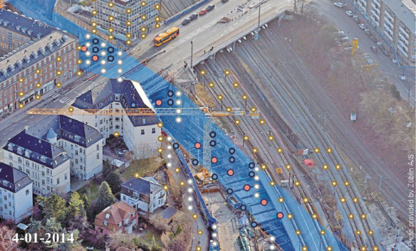
An aerial view of part of the Nordhavnsvej construction; colored dots indicate sensors and measurement points on buildings and transportation infrastructure.
Other small projects include microtunnels, construction of railway underpasses, and reconstruction of underground utilities. With smaller budgets and shorter timeframes, the projects benefit from automated measurement and analyses. LE34 can install monitoring sensors efficiently and operate a system for a few months before moving its assets and personnel to other tasks.
Nørmølle emphasizes how experience gained on large jobs carries over to smaller projects. It’s important to be ready to give quick and accurate answers at all times. In addition, a deep knowledge of all the assets is key.
“If you receive no alarms, it may be a good sign,” he said. “But it might also indicate that part of your system went down. You need to be alert 24/7.”
Every day, technicians check that the systems are operating and validate the incoming data. For each job, LE34 always has one person on duty who can respond to any event reported by the system.
Sustaining the Success
LE34 expects that monitoring and technical surveying will play a key role in the company’s continued success. Sustainable and resilient, livable cities will push more infrastructure below ground, resulting in more challenging design and construction practices. As urban densification continues, demand for monitoring will grow.
“We like to say that monitoring produces safe and sustainable savings,” Nørmølle said. “Monitoring makes it possible to actually cut down on the structure without risking anything, so you can save materials and so on. Because monitoring can tell exactly what a structure is doing, you may not have to spend as much to reinforce it and protect it.
“Similarly–and this relates to the NATM–savings can come from revising designs once a project is underway. Say you have a design for a tunnel or bridge. Once you start monitoring, it can turn out that the forces operating in one area of the structure are not as high as you were expecting. In that case, you can cut down on the concrete and steel going into that specific part of the structure. Monitoring lets you focus money and resources to where they are most needed.”
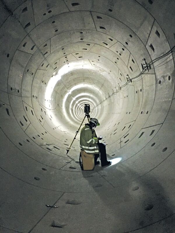
An LE34 surveyor at work in a tunnel; the company combines campaign measurements with automated systems to provide comprehensive monitoring solutions.
Virtual Sensors: The Gestalt of Monitoring
Modern monitoring solutions can capture data from multiple sensors and sensor types. For example, in addition to basic positioning data gathered via optical or GNSS measurement, a high-rise construction site may contain sensors for temperature, humidity, air pressure, and wind. GNSS positioning in an open-cast mine may be supplemented with data from geotechnical sensors. Monitoring of large bridges may incorporate positioning, extensometers, and vibration sensors.
Engineers analyze information from the various sensors to understand the correlation of motion on a site or structure with external forces. In many cases, engineers must export monitoring data from the various sensors and develop external post-processing procedures to prepare deliverables and analyze the results. That’s the gestalt of monitoring: the combined data is more useful than results from individual sensors.
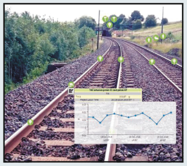
A virtual sensor displays the slope between two prisms on a train track. The software enables users to correlate and analyze data from many different types of sensors in real time.
Trimble 4D Control software uses virtual sensor technology to enable users to combine concurrent information from multiple sensors in real time. Users can define specialized calculations using data from different sensors. The results of the computations can then be treated as a new sensor, including creating reports, graphs and alerts based on the output from the virtual sensor.
A simple illustration is monitoring the slope of a railway track. Using the position of two prisms attached to the track, a virtual sensor can compute the distance and slope between the prisms. The data can be displayed in real time and updated each time the prisms are measured. Users can examine the output of the virtual sensor over time to understand the correlation of data from the multiple inputs.
Virtual sensor technology in T4D provides a tool to analyze and visualize the complex interaction of forces and motion in natural or built structures. The solution enables surveyors and engineers to meet unique and demanding requirements for monitoring applications.