New solutions bridge the gap between CAD and GIS.
Editor’s note: In our continuing examination of CAD-GIS integration we’ve presented several approaches and products. Internationally, a tremendous amount of work has been done towards integration, both in academia and in commercial software; here we introduce you to Graebert GmbH, German developer of popular CAD software that’s beginning to offer solutions in the U.S. & Canada. Theirs is a unique approach to rules-based GIS, particularly for BIM from within a CAD environment.For decades, computer-aided design (CAD) and geographic information systems (GIS) have been like oil and water.
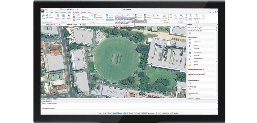
ARES Map is a hybrid
solution bringing together the intelligence of Esri’s GIS contents and a full-featured dwg-based CAD system.
CAD users, who see their work as engineering-based, focus on very accurate measurements and high-precision placement. They view GIS as neither accurate nor precise. GIS users, who see their work as larger scale and more cartographic in nature, cannot achieve the same accuracy over large geographies. While CAD is mostly about points and lines, GIS is also about polygons, imagery, and colors used to convey large amounts of information. While both have attributes and layers, users treat them and store them differently.
In recent years, building information modeling (BIM) has emerged as a third parallel universe in the architecture, engineering, and construction (AEC) sector.
Ultimately, full integration of CAD, GIS, and BIM is both desirable and inevitable because planners, architects, engineers, and contractors need all the details of location, size, shape, materials, and infrastructure. It is also much more efficient to have systems with similar file structures so that they can more easily be stored in central databases.
The goal is to build very accurate 3D models that allow analysis and management of real-world attributes. Ideally, users will be able to zoom in smoothly from a large geographic extent to an individual building—including the geophysical characteristics of the soil beneath it, its cadastral data, and floor plans. They then will be able to zoom down to each building component, while also visualizing the relationships between components, such as stress, wiring, and thermal conduction.
 Autodesk, Bentley, Esri, and Hexagon, as well as dozens of smaller companies, have developed solutions to integrate CAD and GIS as well as tools to convert files between these formats, often focused on particular vertical markets such as utilities or parcels. Yet, many legacy issues in the history of these two technologies, as well as the ways in which the mindset of engineers differs from that of experts in mapping and GIS, have limited the efficiency and effectiveness of these attempts at integration.
A Non-traditional Approach
In October, Graebert GmbH, a German company that has specialized in CAD for more than 30 years, announced the upcoming release of ARES Map, a hybrid CAD-GIS solution it created in partnership with Esri. It merges Esri’s ArcGIS Online with Graebert’s DWG-based ARES Commander CAD engine, which has hundreds of CAD features. Maps, floor plans, and infrastructure created with ARES Map are saved natively in DWG format, but each entity also contains GIS-enabled data. ARES Map runs on Microsoft Windows 7/8/10 and supports DWG 2013 – 2016.
According to Graebert, ARES Map will help Esri users “convert CAD information into smart GIS-enabled entities” and enable them to choose a coordinate system among hundreds of projected, geometric, or vertical options. At the same time, by connecting with Esri’s servers, users will benefit from Esri’s base maps and feature services and will be able to access their own GIS information from an ArcGIS Online account. Conversely, ARES Map will benefit CAD users by enabling them to add GIS intelligence to specific CAD drawings.
One key feature of ARES Map is that it maintains the integrity of GIS information by preventing users from violating the definitions and constraints defined by the GIS administrator for each attribute field. The system will also automatically reject entities that do not qualify for the relevant feature service definition.

Felix Graebert is the product manager for SiteMaster and
Robert Graebert is the company’s CTO.
CAD-GIS for As-built Surveying
Graebert provides worldwide surveying services and developed the SiteMaster line of as-built 2D and 3D surveying solutions, which it built on its ARES engine more than ten years ago. It is used for surveying buildings, especially to precisely measure their size and to determine their condition, says Felix Graebert, SiteMaster’s product manager. It is also used, he adds, to collect information regarding fire and other safety hazards, the kind of wall material, the kinds of windows and radiators, etc.
To measure distances, Graebert pairs SiteMaster software on Windows notebooks and tablets with Bluetooth-enabled Leica Disto hand-held lasers so that the measurements are transferred directly to the software. “You very quickly measure a room and then already have the square measurements and all the information you need,” says Felix.
If you scan a room or a building with a cloud scanner that collects millions of points, you then have to trace over the points to get, say, a floor plan. “With SiteMaster,” he says, “you can collect only the required information. Once you’ve measured a room, you can see it in SiteMaster, you can see it on a cut plan, you can see it in DWG.”
You can use SiteMaster to collect data on a new build, import it into ARES Map, then export it to GIS. “We can even go further and collect coordinates with GPS, or we can use the GIS data, convert it to CAD, and then work in that environment, with SiteMaster, to determine exactly a building’s footprint,” says Felix. “We can also use the building’s coordinates and work from the outside to the inside to measure the building’s floor plans. If we survey a building, then we can even use the GIS data—for example, the utilities—and bring it into the cut plans or building plans.”
SiteMaster grew out of work on building a mobile CAD system, recalls Robert Graebert, the company’s CTO. “We quickly realized that you do not just want to look at CAD files; you want to do something with them. From that foundation, we built a very robust building surveying tool that will create a finished design in CAD, on your phone, on the road.”
In the last couple of years, Graebert released a version of SiteMaster that can automatically capture 3D surveys and a version it calls SiteMaster Kitchen, for taking surveys of kitchens. In Europe, Robert explains, many kitchens manufactured to specifications don’t fit in the available space. With SiteMaster Kitchen, a technician can survey a room intended as a kitchen, and the survey is then used to update the design of the furniture.
A Whole New Look – at GIS
“We have a deep history in CAD,” says Robert. “We come to the GIS world as novices. Our business is working with other CAD companies or companies that have a CAD need to understand how our technology can help them. In the CAD space, we are mostly known for .DWG-based editing tools. So, people who have been trained in AutoCAD or AutoCAD LT are very familiar with how to use our tools and we have partners all over the world that license this technology. The biggest one is SOLIDWORKS/Dasssault Systèmes with the DraftSight package that has more than 7,000,000 downloads.”
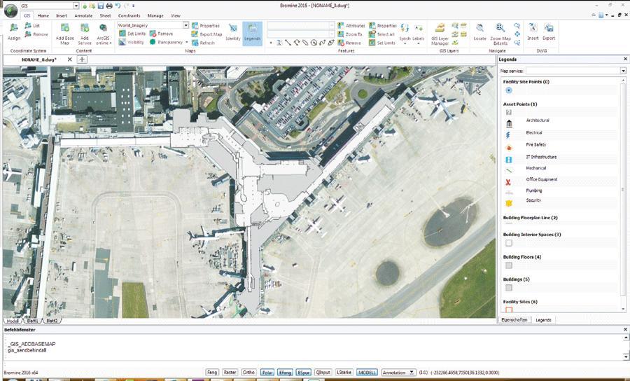
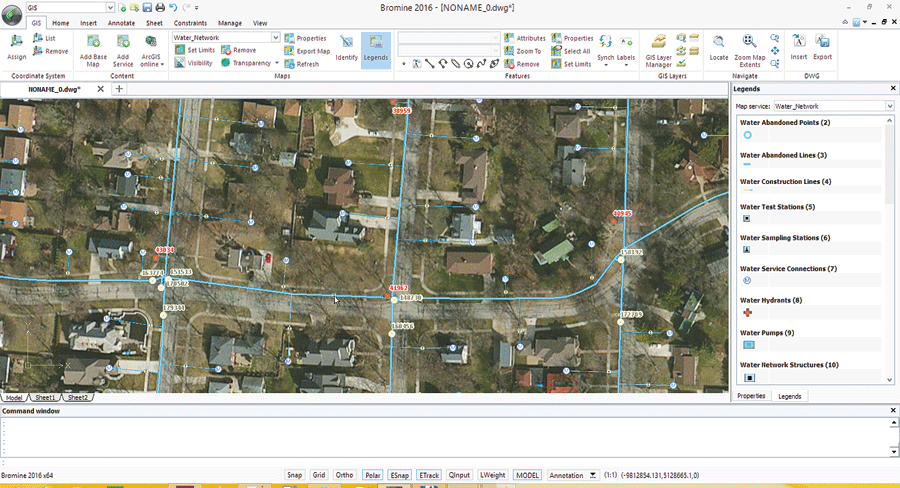
Using ARES Map, you connect to your ArcGIS Online account to load your map and feature services. You can update the information and publish modifications.
As chairman of the board of the Open Design Alliance, an industry consortium that develops DWG toolkits, Robert has been learning more about GIS through Esri and realized how, in many organizations, CAD and GIS departments “live next to each other, although they overlap in the data and designs they touch.” For many organizations, he explains, “the big pain point is when they try to migrate CAD data into GIS or try to edit CAD data once it is in the GIS. CAD and GIS products have very different interface paradigms, so CAD users will not necessarily excel at GIS.”
Graebert, Robert explains, created ARES Map to bring the power of GIS solutions to CAD designers and engineers who have little or no GIS background but are very familiar with DWG-based CAD. “We realized, for example, that in the United States, public works organizations that work with engineering and design firms have that need.”
Automating Rules-based Integration
Often, in organizations with digital deliverables, data originally produced in CAD is faulty by the time it is stored on an online GIS server. ARES Map instantly alerts users to properties that violate a GIS’ schema.
“You pick the base map and locate where you want to go to,” says Robert, “connect to your proprietary or public services and add the map services as a visual reference point, but you then work directly in the features, as native objects to the CAD system. Once you are done making your changes, you synchronize back to the service, and your map server will refresh, and so, right away, you will see everything that is done and whether it has gone through correctly.”
Additionally, Robert sees the launch of ARES Map as an opportunity to bring into the GIS fold some of the CAD developers who have built specific design solutions on top of CAD solutions by providing them with a familiar programming interface. “The advantage for the developer is that we can process the design content they generate for them and make sure that they can be added and synchronized to GIS services.”
“We are very much at the beginning of this,” Robert adds. “We are initially working with a company in the United States in the facilities space and are expanding this to other industries as well as partnering with Esri distributors globally.”
The Changing Enterprise — Data Environment
Ten years ago, Robert recalls, there was a lot more work on combining CAD and GIS. Based on what he has learned in the last few months, his sense is that many organizations have completely migrated to GIS for their enterprise geospatial data, so the CAD use case may not be as visible as it was in the past.
“CAD/GIS integration is broken, and some organizations have moved on and standardized on GIS. However, we do think that a use case exists and we want to prove it and figure out how big it is and how strong a need for users,” says Robert.
On the other hand, 3D still needs more research, he argues. “For now, we want to be a really good feature service editing environment within a CAD tool.”