How a service provider for utilities implemented a mobile app to clock up efficiencies in advanced meter systems.
Editor’s note: Mobile apps for asset mapping and mobile data management went from “new-cool” to essential in just a few years. In our April issue (see Mapping Peripheral) we tested a peripheral device that can add precision GNSS to mobile devices (phones, handhelds, tablets). In our field-testing we used an equally cool mapping app called TerraFlex. To examine real-world applications of TerraFlex, we found a utility service provider, SL-serco, who took the app and ran with it in a big way. Recently, their implementation of this new mobile data and mapping capability has enabled them to combine old and new data in their GIS data collection technology, resulting in even greater job efficiency.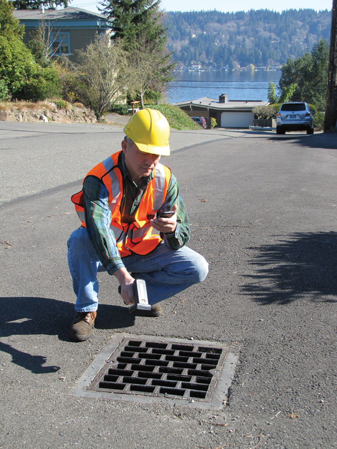
The proliferation of mobile devices and cloud-capable mapping apps like Trimble TerraFlex enables crews to improve service and reduce costs by providing real-time validation and access to infrastructure data. Peripherals like high-precision GPS/GNSS receivers and other test sensors can be paired with mobile devices; in this example a handheld RFID reader has been paired with a smart phone.
The company SL-serco optimizes systems for water, electric, and gas utility providers. It does this by data analysis and process consultation for their automated meter infrastructure (AMI) and advanced meter reading (AMR) systems. The company’s services include process consulting, training, and data evaluation. It employs 30 people throughout the U.S., with nine of those based in the home office in St. Anthony, Minnesota. Reed Sutter is the manager for AMI/AMR systems support.
The AMI systems that SL-serco supports rely on accurate data, according to Sutter. “Due to the critical nature of utility operations, utilities need rapid response to any issues that arise,” he said. Their work includes troubleshooting, auditing meters through onsite visits, archiving data, and generally guiding operations. All these activities are essential for ensuring that metering systems are healthy and efficient.
Sutter and his teams have long relied on electronic data collection rather than pen and paper, but until recently their efforts to increase ease and efficiency have been hindered by the inability of data-collection devices or apps to combine old data with new data quickly, for example, when the team is evaluating meter replacements. “You have to marry new information to old records so that account data can stay consistent,” said Sutter. “In the beginning we tried lots of different technology tools, but their collective inability to integrate data was always limiting.“
Data Collection Efficiency
In 2013 SL-serco was contracted to record the assets of a water utility as part of a study for a proposed fixed-base metering system. To audit assets such as water towers and pump houses, SL-serco staff had to collect attributes such as GPS location, structure height, the presence of a power source, and altitude.
Because they required accurate GPS coordinates, Sutter and his team for the first time adopted the Trimble TerraFlex data collection app. They ran TerraFlex on a variety of devices, including iPhones, iPads, Windows Mobile, and Android devices.
“Although at that time TerraFlex didn’t enable us to combine old and new data, the app worked excellently,” said Sutter. Collecting GPS coordinates immediately created opportunities for SL-serco to increase efficiency around data collection just by more accurately locating meters on a property.
For example, if a water utility account holder owns a 100-acre property, the city may provide only one GPS location for the entire 100 acres, and that point may not necessarily match the meter’s location. Now SL-serco’s process can attribute the GPS coordinate to the meter, not just the general property point that the city has for the property.
However, the first immediate benefit TerraFlex provided was via its customizable form capability. Sutter now creates forms in TerraFlex with all the different kinds of fields he wants.
“We make a test version of a form for each project,” said Sutter. “We do a little bit of work on the test version, train the guys on it, and then make any necessary refinements.” In the unlikely event that the form needs modifying mid-project, Sutter makes the changes from where he’s located. The updated form is pushed out to staff the next time they sync up. This way data collection is always consistent.
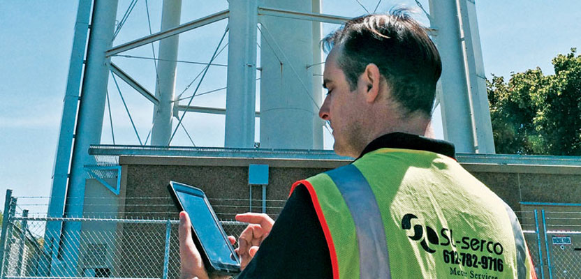
Reed Sutter, support manager for automated meter infrastructure (AMI) and advanced meter reading (AMR) for SL-serco maps
infrastructure at a water supply facility.
“The forms are really easy to use. I get very few calls with questions once the utility’s guys are out in the field,” said Sutter. Armed with this customized tool that meets their needs exactly, the utility’s teams can collect meter data quickly and efficiently. The data is then automatically transferred via TerraFlex to the cloud for access by their office colleagues.
A fairly typical AMI project is one that Sutter organized in the Caribbean Islands, where asset information was required for a major water provider for a proposed AMI. During the project Sutter visited 100 sites over 10 days, collecting altitude information, geo-referenced photos, and other measurements. The job presented several challenges, including a frequent lack of network connectivity. Many times Sutter was unable to acquire GPS location information.
TerraFlex allowed him to enter data while offline and then simply synchronize his device when cell coverage was again available. When he needed to geo-reference an asset but GPS data wasn’t being logged, the process was again quite simple—Sutter would manually place the dot onscreen when collecting the data; later he would add the GPS location via a Google satellite image.
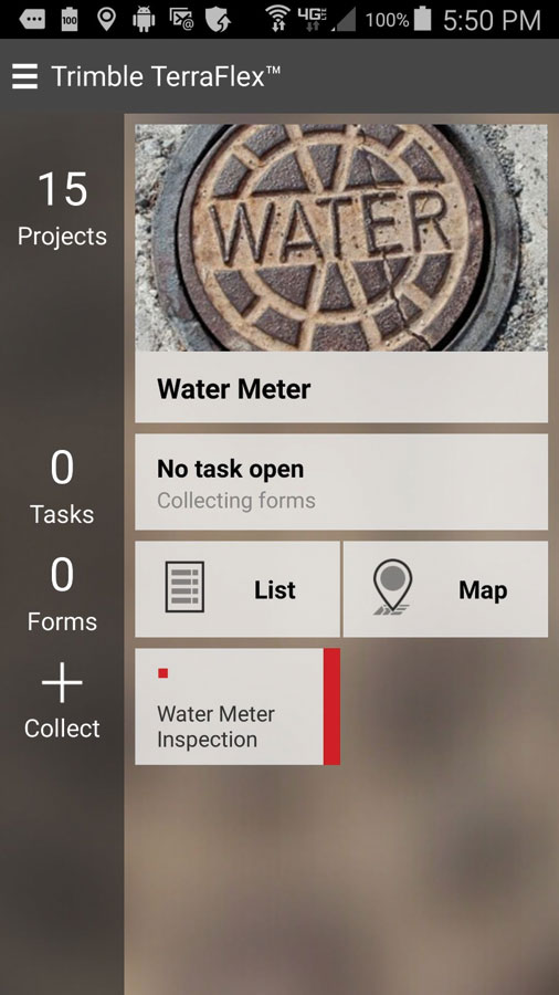
Here a custom form has been created for a water meter inspection campaign. Once the infrastructure has been validated, field maintenance crews, meter readers, and inspectors will have real-time records on their mobile devices and a way to note and submit changes during operations.
Old and New Data Integrated
“Things got even better last year when TerraFlex Advanced was introduced,” said Sutter. “Finally we could combine our old and new data and put TerraFlex to work on a lot more jobs.”
For many auditing tasks, it’s important for SL-serco to have tracking capability for certain events, e.g. for meter change-outs where a new meter replaces an old one. “Now, by starting with an existing record we can import previous data and attach new installed meter data to it just by creating a new form,” said Sutter. “When a utility staff member inputs data, they’re just adding information to an existing record.“
The integration of old and new data makes re-routing sequences with GPS coordinates faster and easier, too. SL-serco’s AMR customers typically hold a set of accounts, where each account has an associated meter ID. The accounts are sequenced in a particular order for maintenance.
Often the historically assigned sequence is not the most efficient one possible, but by collecting accurate GPS coordinates for existing meters in TerraFlex, SL-serco can create a faster sequence or route to follow based on the location information. Better routes save considerable time on maintenance projects.
Off-the-Meter Efficiency
Once upon a time, six utility field workers collecting data might result in forms being completed six different ways. By using an advanced-technology solution for collecting data and making the most of accurate GPS locations, SL-serco utility clients have transformed their work processes with “off the meter” efficiency. Sutter says, “Our clients are able to use Terra-Flex Advanced for repair, rerouting sequences, data collection for radio signal propagation studies, and more. It’s really simple to use and very reliable.”