This proved true for Manchac Consulting Group, Inc. when they recently teamed with Louisiana’s Bossier City to solve an infrastructure issue. The project provided the chance for Manchac to expand their GNSS capabilities, an expansion from which the company is continuing to harvest fiscal rewards.
Having hired Manchac in the past for design and engineering solutions, Bossier City Public Utilities Department called on them to solve an issue with their sanitary sewer line. “Certain areas of the city were getting too much flow, or there were blockages of flow,” said Manchac GIS department manager Chris Chandler.
The city had GIS data on the main sanitary lines but, due to these recent trouble areas, there was suspicion that some inaccuracies might exist. The existing data needed to be evaluated, and the elevations of the sewer line at several manholes would potentially be re-mapped.
The purpose of the project was three-fold.
1. It would provide Bossier City with an up-to-date inspection report on all of the manholes on the main lines to identify potential problem areas.
2. The dataset of elevations along the sewer lines could be imported into the city’s Bentley SewerGEMS program where it would generate a prioritized sewer rehabilitation plan.
3. Collected data would be used to generate a new sewer model that would also incorporate population projections to develop a future-conditions (year 2030) sewer system model.
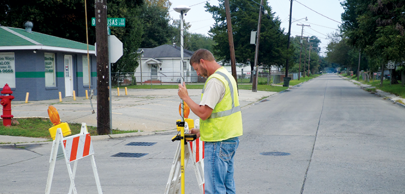
In the preliminary stage, Manchac measured the location of a sample set of manholes on the city’s main sanitary lines to ascertain the quality of current data they had. The new measurements showed that the legacy data had discrepancies as great as 5 feet vertically. This confirmed that the original dataset was compromised. The decision was then made to re-measure location and vertical on 668 of the city’s manholes to produce a new, higher-accuracy dataset.
Instead of subcontracting the following stages of GNSS work—as the scope of job requires more than just positional measurements—Manchac saw the opportunity to perform the work in-house. They chose to upgrade their sub-meter GNSS handheld (Trimble’s GeoExplorer 6000 series) to the centimeter edition (what’s now the Geo 7 series). The logic behind the centimeter-accuracy upgrade was simple. “If we’re going to be there gathering data on the manholes,” said Chandler, “let’s get the best data we can possibly get.” They also upgraded their field software, TerraSync.
Manchac also purchased a high-resolution digital camera and special software (the Trimble TrimPix Pro system), which allows a camera to link in real time with the GNSS device and store the photos together with the coordinates and other attribute data. Exterior photos of the manholes were taken to assist in identifying and relocating them later while interior manhole photos were taken to illustrate their general condition.
From fieldwork to post-processing, the project spanned a total of eight months. According to Chandler, the results were exceptional, with vertical accuracies within 1 to 2 inches (2 to 5 cm). Bossier City Public Utilities director, Jeffery Anderson, PE, was very pleased with the work performed by Manchac. “[They] collected a great amount of information that will be easily integrated into our existing data,” said Anderson. “The data is invaluable to my department for maintenance and repairs.” As for measuring success on the side of Manchac, the company saw a rate of return of 242% on their new investments.
The new equipment and approach is now opening doors for Manchac Consulting Group. Shortly after the work in Bossier City, the company accepted a similar sanitary line project in Lake Charles, Louisiana. Chandler noted that they were able to modify the data dictionary they had used on the project in Bossier City, tailoring it to fit the needs of the project in Lake Charles. “In the past,” said Chandler, “we were passing the buck to send these projects to someone else. Now, with our new in-house resources, we’re able to take advantage of them. It’s been an excellent investment for us.”