Periodically, large sandstorms and low-visibility conditions wreak havoc in the Middle East, with potentially deadly consequences for drivers. In 2007, a sandstorm in Saudi Arabia caused a pileup involving about 80 cars. In 2008, low-visibility conditions caused a 200-car pileup on the border between Dubai and Abu Dhabi, killing about 25 people. In April 2012, a sandstorm across the United Arab Emirates caused a 23-vehicle pileup in which a dozen people were injured. In 2013, a sandstorm shut down the Dubai airport for three days.
“The 2008 disaster was a major event here, and that’s when the authorities felt that we should have a system not only for monitoring but also for forecasting such events,” says Shaijan Baby, senior sales manager for the survey department of Unique System FZE, a provider of subsea and offshore solutions wholly owned by the Unique Maritime Group.
The geodesy and hydrographic survey section of Dubai Municipality (DM) contracted with this company to develop a mobile application that alerts users about an approaching sandstorm. The system works by means of a combination of ground monitoring stations, satellite data, and a predictive model on a DM server.
The new mobile application, launched in June, makes Dubai the first emirate to use the Sandstorm Forecasting System, which gathers information from a network of automatic weather stations (AWS) and from global forecasts. It is an extension of a website launched three years ago to monitor weather data, provide alerts, and disseminate information to relevant agencies.
From the AWS, the data goes via GSM/GPRS to an Etisalat tower that relays it to the servers at DM. A typical alert can give six to eight hours’ advance notice of a storm by means of an audible sound on a mobile phone as well as an email alert.
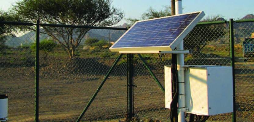
“We have eight terrestrial meteorological stations spread across Dubai,” says Baby. These stations—which Unique System established in partnership with MicroStep, a Slovakian company—include sensors for parameters that affect visibility, such as wind, humidity, soil moisture, and soil temperature. The system also includes five recently upgraded tide and meteorological stations and two offshore data buoys. “So, we collect meteorological parameters and marine parameters.” During the upgrade, all stations were equipped with new rain gauges and tide staffs. A professional meteorologist analyzed the data and created daily sandstorm and visibility forecasts.
The same data is now available in the mobile application, which can be downloaded on all the latest versions of Android. In addition to warning motorists about road visibility conditions, the application helps residents plan their outdoor activities and helps protect allergy and asthma sufferers from potential health risks.
It can also assist government entities—such as the Dubai police, coast guard, and Road and Transport Authority (RTA)—to plan safety strategies well
in advance. “We have a 1D model for fog forecasting and a 3D weather forecasting model,” says Baby. “The visibility forecasting system has been working for the last four years now. It provides data to the Dubai police and RTA on an hourly basis. The model takes the global forecast, which has a resolution of about 200 kilometers, and breaks it down to a localized grid with a resolution of 1.8 kilometers. The data is monitored by a forecasting service provided by MicroStep, and the alerts are given to the local authorities by the forecasting service, not automatically by the software.”
DM is now trying to increase the number of people using the application. To ensure the quality of the forecasting data, it has been testing the system for the last two years. “Now they feel comfortable,” says Baby.
In addition to the mobile Android application, the information is also disseminated through a Web server kept outside DM’s firewall and through a public website that displays the alerts and the forecasts in real time. Users can also look up the raw data and the trending from each of the stations. “We are just launching an iPhone application which probably will be similar to the Android application and also available for the public,” says Baby.
One technical challenge in setting up the system was the dearth of historical data for the relevant parameters. “To help fine-tune the model, MicroStep collected the historical data from various sources,” says Baby.
Will DM’s application be a model for other systems? “We are in discussion with a few clients in the region that are interested,” says Baby. “The mobile application was a big hit here. Many people began to use it, and it is open to anybody in the region or outside. So, that is creating a lot of interest, and we hope that we will have a few more such installations.”