It was a beautiful early summer day, ideal weather to take a road trip to the Pike National Forest about an hour from my Eastern Colorado home. Pike National Forest comprises 1,106,604 acres southwest of Denver and is a frequent haunt of mine for camping, off-roading, and in past years dirt biking and ATV-ing. This time, I decided to revisit an old campsite of mine and document the trip with my Bad Elf Pro+ GPS device.
Bad Elf makes a variety of external GPS app-based solutions that work with Android, iOS, and Windows platforms. The devices work with a wide range of location service apps and all iOS location service apps and they enhance the location accuracy of your smartphone or tablet. I opted for the GPS Pro+ device which adds GLONASS GNSS to the GPS Pro unit.
As an example of how the device can improve a device’s location accuracy, I did a little test with my old iPad 2 which has no GPS chip. First I opened Google Maps that showed my location in my neighbor’s backyard, roughly 260 feet off. Then I connected the iPad with the Bad Elf via Bluetooth. I watched the location icon zoom over to directly over my house, right over my head. Much improved.
The Pro+ is rated at 2.5 meter accuracy, not quite good enough for most surveying applications, but it meets my needs for recreational uses and probably for less-demanding asset-management applications. The top of the line is the GNSS Surveyor with 1 meter accuracy that can be enhanced through post-processing to 10-50 cm.
Back to the road trip. I rambled south down the Rampart Range Road, the main road that more or less longitudinally bisects the National Forest. I turned west on Long Hollow Road and found my old campsite. I turned on the Bad Elf, connected it by Bluetooth to my iPhone, and then enabled GPS data logging. Then I hit the trail to my old campsite.
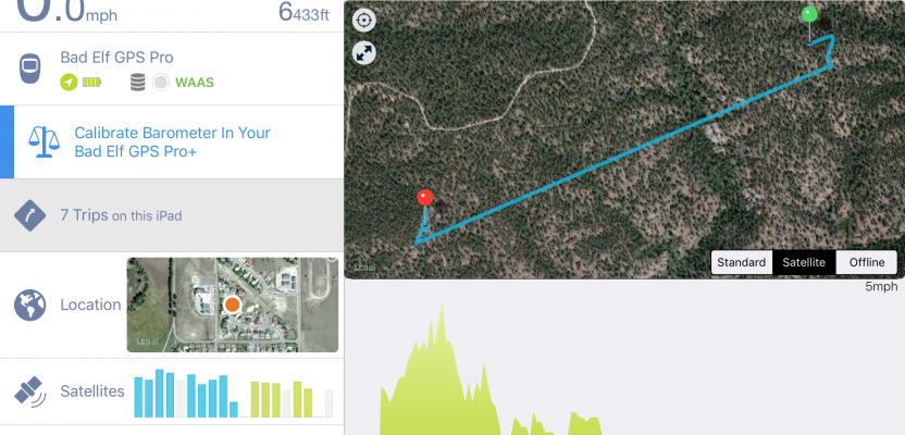
Arriving at my tenting spot, I hit the GPS button again which allows users to either toggle off the data logging or add a point of interest (POI). I added a POI at that spot and then headed back to my SUV.
As a second test, I drove through some back Jeep trails to find a “Southwest Passage” out of the area. It does exist, but it is a bit more challenging, and since this trip was a solo mission I decided against risking it for safety reasons.
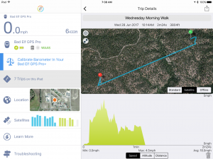
Once home I opened the Bad Elf app (screenshot above). Both my walking and driving GPS data logs were updated via Bluetooth from the Bad Elf to the app and were available for viewing and analytics. The dashboard is feature rich: on the right top of the app, there’s a map displaying the selected trip and POIs, along with speed, altitude, and distance. On the left the display shows the stored trips, the number of GNSS satellites connected, and more.
As an added bonus, trips and POIs can be exported to both Keyhole Markup Language (KML) and GPX (GPS Exchange Format) and opened in a host of mapping programs like Google Earth, Google Maps, and OpenStreetMap.
Whether you’re documenting a backroad trip, managing far-flung assets, or just trying to get better accuracy out of your smartphone, a Bad Elf can be a good thing!