xyHt has been watching a recent flurry of news releases and webinar announcements from Trimble tagged with the slogan “Time to Do More.” There were quite a few major new products and enhancements announced so we wondered: Was this simply a marketing campaign? Or was this some new direction for Trimble? We decided to ask them directly and spoke with Phil Sawarynski, Trimble’s Business Area Director for Survey and Engineering, Geospatial Division.
There were many new products being launched all at once targeting professional surveyors, engineers and GIS professionals, so rather than announce them piecemeal, noted Sawarynski, the Time to Do More campaign is a way to communicate information about the expanded solutions portfolio in the context of complete product lines. “We’ve had complete product lines for a long time,” says Sawarynski. “We are emphasizing these complete lines, but we have also added more options for the customer to choose from, and these are scalable.” This “have it your way” approach had already been applied to a number of their product lines (like their GNSS base receivers) for a number of years; now it appears this will be applied across the entire Trimble Geospatial portfolio.
“As we continued to listen to our customers across a wide spectrum of industries,” said Sawarynski, “one size fits all does not really work anymore. The work is not the same in different industries, in different parts of the country or globally,” he adds. “There are different workflows, standards, regulations, and resources. More is being done with spatial data and the requirements and expectations are changing. Time to Do More is letting the customer know that no matter what kind of work they do, or want to do, how they want to deliver or visualize the data, we have a scalable solution for them.”
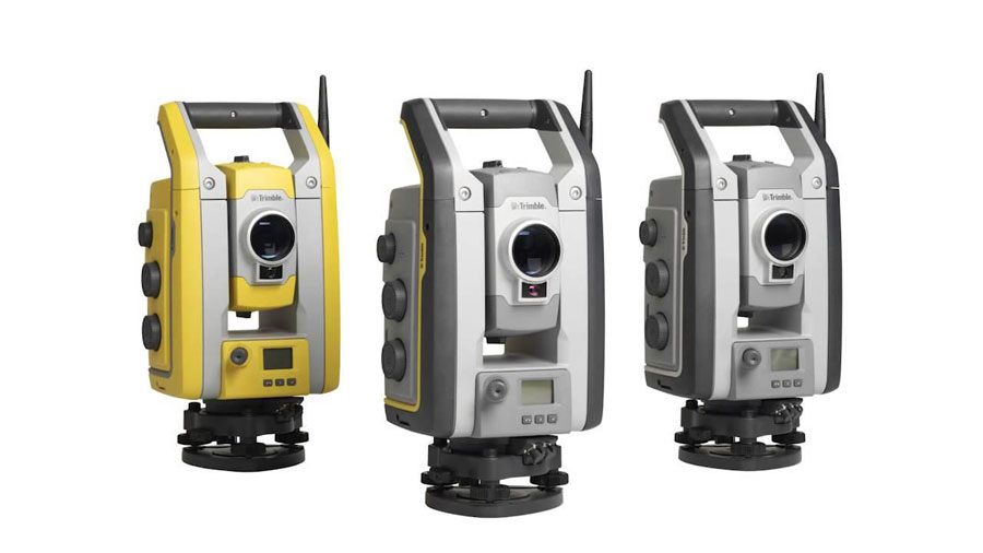
The new S5, S7, and S9 robotic totals stations, with scanning added to the S7
As an example, the “S” series of robotic total stations has expanded; in addition to the S6 and S8 there is now an S5, S7 and S9–and the S7 now has the scanning capabilities that users are familiar with from the VX. The VX is a pioneering product, a platform for innovation in imaging, scanning, and more, so we asked if this was the end of the VX? “The VX is such a pioneering product that we’ve decided to integrate its innovative technology into [various] models in the S series,” he said. Another example is the new R8s GNSS rover; it can be ordered with user-selected combinations of features, constellations, and apps at the right price point – and you can add more later, i.e., upgrade without purchasing a new rover.
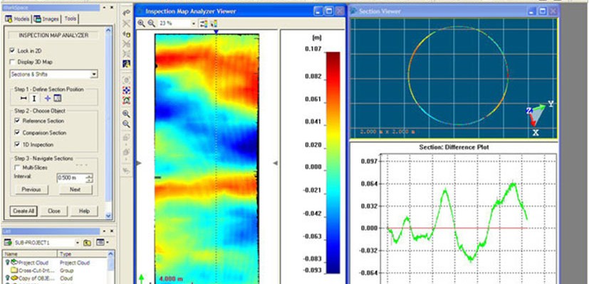
Other noteworthy recent additions include the equipment tracking, management and theft-protection Locate2Protect module (a small GPS/cellular locator device) for total stations and some rovers, and a related Equipment Manager module for the InSphere cloud-based data and workflow management suite. Enhancements to scanning and imaging include a new storage tank inspection report tool for RealWorks, and a new Pipeline Measurement module for Access.

The new storage tank inspection tool in RealWorks.
There is a long list of new products and features – enough to overcome our initial skepticism that Time to Do More was just a marketing campaign. There are a lot of new tools and solutions available across the geospatial industry, and Sawarynski notes that “Trimble is committed to continue to deliver new and innovative products and solutions for our customers now and in the future.”