Unmanned & Unlimited
Unmanned aerial systems (UAS) get the lion’s share of media coverage, which is just not fair. Hardworking unmanned marine platforms, both surface and subsurface, have a lot to offer in the hydrographic surveying and inspection space. As a big bonus there are no FAA exemptions forms to fill out; nor do they require a pilot’s license. Here are two “aqua bots” that deserve a further look: one above and the other below the waves.
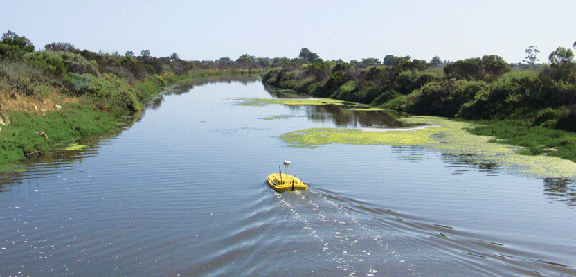
Teledyne Oceanscience Z-Boats above …
Z-Boats have been around awhile, but now the flagship Z-Boat 1800 offers a new and important feature: a fully autonomous waypoint navigation option. It’s an unmanned hydrographic surveying craft typically used in shallow water inshore bathymetric surveys. It’s compact and portable at 180cm (5.09ft) long by 90cm (2.9ft) wide and weighs in at 30kg (66lb).
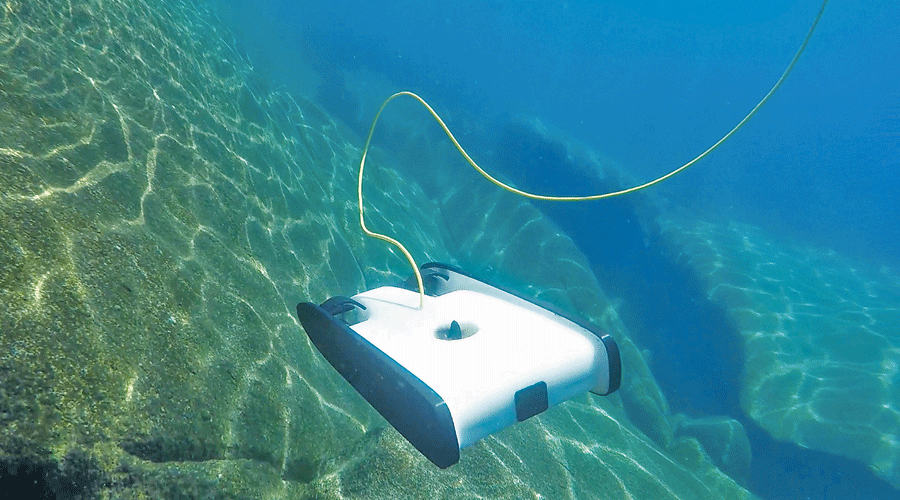
OpenROV’s Trident on a subsurface coastal mission
The unit is compatible with users’ existing GNSS receivers, and all makes and models can be used with the unit, including Trimble R4/R6/R8/5800/R10/SPS-series, Hemisphere A101, A325, S320, Topcon, and Leica. The Z-Boat 1800 can also be outfitted as a turnkey system with Hemisphere GPS. And the Z-Boat is compatible with RTK GNSS receivers.
As with any surveying platform, it’s all about data collection. Four sensor options are available: the Teledyne Odom CV100 Echosounder, a single beam sonar unit, the CEE HydroSystems CEEPULSE, an entry-level survey grade echosounder, the CEE HydroSystems CEESCOPE, an all-in-one hydro surveying system with integrated GNSS positioning, and the Tritech StarFish 990F side scan sonar. On the software side the Z-Boat 1800 offers HYPACK software for survey planning and execution and Eye4Software Hydromagic for data acquisition and mapping.
As mentioned at the outset, the Z-Boat 1800 now offers an optional add-on waypoint navigation module. Besides the benefit of reduced operator involvement, this offers laser-straight survey lines and repeatable survey patterns. This new feature is a leap forward in hydrographic surveying; with it operators can concentrate on surveying as opposed to piloting and bring a new level of accuracy to the field of hydrographic surveying.
. . . and OpenROV Trident below
The folks who brought you the open-source OpenROV have a new model in development that promises to be a real contender in the underwater surveying, inspection, and imaging arena: the OpenROV Trident. Although this unit is in the Kickstarter stage, it has handily surpassed its goal of $50,000 … by more than $650,000. Signs point to a successful rollout.
The Trident is a remotely operated underwater vehicle that uses a neutrally buoyant tether (25 meter with longer tethers sold separately) that controls the ROV and streams live HD video back to the user, and operates up to 100 meter depths. Imagery can be processed photogrammetrically to create underwater 3D models. The unit is controlled and images are displayed via smartphone, tablet, laptop, or virtual reality display including Google Cardboard.
Trident is so sleek and fast (2 meters per second) that the inventors call it an “underwater drone” that users “fly.” From a practical aspect the unit is optimized for underwater surveying with its ability to conduct long transects, i.e. lawn mower patterns, over large areas. Another feature heretofore only available on high-end ROVs is its “depth and heading hold” capability.
The downside of Trident is its lack of any sophisticated sensors, sonar for example, or an IMU/INS. On the other hand, since the Trident, like its predecessor the OpenROV, is an open-source product (both from a hardware and software aspect) the door is left open for modifications to address these shortcomings
The developers list the Trident applications as “marine biology projects, dive site surveys, boat inspections, and underwater exploration.” I would expand that list to underwater inspections of all kinds: water and cooling tanks, bridges, piers, and a host of other similar applications. Trident’s expected rollout is November 2016.