Clients should choose a laser scan primarily when they need to document existing conditions for a future construction or complex renovation project. When complex conditions exist, the risk of a mistake using a tape measure and sketch pad greatly increases the probability of a construction error.
If this matches our clients’ needs, we then discuss with them at length key elements of the deliverables.
Software is where the first real misunderstanding can occur. What type of software does the client intend to use? Project completion is not the time to tell the client, “Oh, by the way, you will need to upgrade to the most current version of your software to use our deliverables.” This can cost much more than the laser scan itself and drops a huge burden on their best CAD technician, who has to learn how to use the upgrade.
We have delivered point clouds and models to clients in 2014 software only to have them tell us that they are using a 2012 version. This is a big deal because, though most of the software packages began including point cloud tools in 2011-2012, these older versions are generally used to view point clouds, not to actually use the data within them.
If your client isn’t willing to update software, suggest deliverables that will work better in their existing software. Many times, this means that we will produce 2D CAD plans, which meet their needs. Other clients are willing to upgrade, and thus we can deliver finished CAD models that are ready to be inserted into their other design models and clashed for interference.
Hardware: Clients also need the right hardware to work with the point clouds. Without that they may not be able to load the data or manipulate the data in an efficient manner. Fast RAM memory,
multi-core processing, good graphics cards, and solid state drives are a good investment. We can usually get what we need for around $3,000, and that’s what we advise our clients. If a client has old machines sitting around, they will generally need to upgrade, anyway.
We deliver most of our projects on portable hard drives. It is not uncommon on a medium-size job to collect 2-gig of data and have 1 billion raw data points. However, the final deliverable into a CAD software can be anywhere from 20meg to 100meg, depending on the detail and the CAD package.
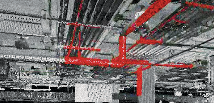
Density of the point cloud is also discussed. The density should meet the expectations of the job. Density on a road, for example, could be one point every one foot, where density on a structural beam could be one point every inch. Density in a very tight, complex area may be one point every 1/8 inch.
Density and accuracy should not be confused. More points is not necessarily better, it’s just more points. A pipe only needs three points to determine the diameter. Although 10,000 points may seem better, only three are needed.
If we collect one billion points on a scan job, we may use 15% of those points to create a model. We will deliver to our client a full data set with all the data, but we will also deliver a data set using 15% of the full data set and another with only 5% of the full data set. We do this because, in architectural projects especially, the density is not needed on floors, walls, or ceilings, and the smaller the “cloud density,” the faster the computer performs.
Selling Clients on the Benefits
If we communicate well, our clients get solutions that make their job easier. It is our job to show them examples of how we used these tools on other projects to determine what will work best on their project.
Recently, we were working on a hospital project for an architectural firm with offices in multiple states. When we did the walk-through prior to beginning the job, we asked if they also needed information on a major pedestrian bridge adjoining the project and connecting the building to a parking deck. The answer was “No,” but because it was in the area that we were scanning anyway, we included it in the final point cloud. Ultimately, most of the questions on the project were related to that pedestrian tunnel, so they needed the data after all.
While talking with another client, I happened to mention that often I send out PDF files of our 3D models. He had no idea that he could get a model this way. The advantage of having the PDF is that most executives can access this kind of file on their laptop. With a PDF, not only can they view the data, they can comment and review the model.