Some professionals predicted doom for terrestrial scanning right when inexpensive drones with calibrated cameras hit the market and new image processing software wowed audiences with cool 3D mesh models of statues. But how have things actually turned out? I recently interviewed key industry users and vendors who are deep into both technologies – here’s what I found.
Complementary!
Literally, everyone I spoke with quickly raised their hands for the two technologies being mostly complementary rather than competitive, citing many compelling reasons and practical examples.
Accuracy
The first reason cited for the two technologies not being directly competitive was that they don’t achieve the same accuracy. In this case, “accuracy” was not only the arithmetic +/- aspect, but also the detail/point cloud density aspect (once drone images are post-processed into point clouds).
They also differ in their “ability to prove out the data,” with laser scanning universally cited as more accurate, more detailed, and easier to prove out.
Static laser scanning was generally accepted to achieve 1/4″ accuracy with a best of 1/8″. Cited drone accuracies varied. They depended on the specific tools used and on field and office processing methodologies. A leading drone dealer quoted “0.1′, if done right”; a leading photogrammetric software vendor cited 1/2″; and a sophisticated user cited 1/2″ to 1″ for a drone roof survey. However, when drone users and vendors opened up about their actual drone applications, practical accuracy differences between the two technologies were quite revealing.
In one extreme example, an engineer from a large contractor told me that they’ve used drones and laser scanning for dirt volume surveys. He said drone results are typically within 10% of scanning results but can be off by as much as 20%!
Here’s a sampling of other practical examples that spoke to accuracy differences:
- Drones are used for planning/conceptual design, while laser scanning is used for detailed design.
- Drones are used for groundwork estimates, laser scanning for groundwork payments.
- Drones for parking lot lines, laser scanning for detailed hardscape.
- Drones for rooftop equipment locations, laser scanning for vertical/facade and interior details.
- Drones for fields and wetlands, laser scanning for architecture and industrial plant structures.
- During construction, drones are used for progress monitoring, seeing what’s going on at the site and documenting pre-existing cracks in adjacent buildings as future litigation protection. Scanning is used for construction QA/verification, truck and crane clearances, pre-pour documentation, and floor flatness surveys.
- Reinforcing the point, a manager from a construction company using both technologies on the same project said drone orthomosaics are used for context, while scan data is used for measurements.
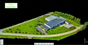
Above: A drone was used to capture this building’s site and roof top; Below: scanners were used to capture the building’s interior beams and truss geometry. Credit: Hale TiP.

Imagery
From a logistical standpoint, UAVs’ unique 3D perspectives, wide-area views, and high-resolution imagery are clearly a huge strength. Most professional drone usage, in general, is for inspection purposes or wide-area, overhead images (e.g., real-estate marketing). Although scanners have built-in cameras or can be complemented with panoramic cameras, they don’t provide drone-type aerial images and certainly not with the same productivity.
Productivity
Where drone accuracy is sufficient, e.g., volume surveys for landfills, gravel pits/mines, and stock piles, drone productivity offers a big advantage. Projects can be done in a fraction of the time and cost of a laser scan survey; adding survey measurements to improve accuracy of drone surveys incurs some additional time and cost.
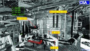
Laser scanning’s high accuracy and dense point clouds enable scanning to be used for industrial and power plant as-builts; drones are not suited to this type of application. Panomap image credit: CSA.
Risk/Liability
Like it or not, a flying drone carries a safety and liability risk. One public company staffer cited potentially negative press were a drone accident to occur, so the company tended to use drones on projects where few people were present.
Access to Licensed Pilots
Professional drone use requires operation by a suitably licensed pilot, which can be problematic if one is not available for an intended project.
Service Pricing/Commercial Appeal
The market has bought a lot of drones in the last couple of yearsÑin the tens of thousands. Their extremely attractive entry price – on the order of $1.5 to $3k for the most popular, professional drones – has quickly flooded the lower end of the market with drone/UAV service providers. Many are new to the technology.
The upshot is that some people feel that drone service pricing has quickly reached commodity level and some work is not up to professional standards. Laser scanning services have also become more competitive, but the general sense is that there’s still enough service differentiation and well-earned client loyalty to support good returns.
Bottom Line
So, have UAVs spelled the doom of scanning? Hardly. I estimate that less than 5% of static laser scanning service work has been replaced by drones.
One user of both technologies said that drones are probably more directly competitive with mobile scanning. For surveying, mapping and related professionals with static scanning capabilities, drones are an attractive complementary technology.
Examples of projects where both are used together include buildings (scanning for interiors and for exterior vertical surfaces; drones for roofs and overall outside sites) and crime scenes (scanning for interior scene details and bullet trajectory rods; drones for overall outside site and context capture).
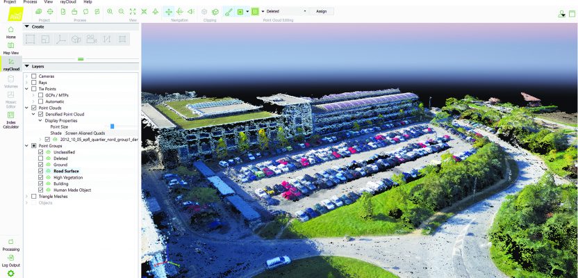
Image at top: The true-color point cloud was derived from drone photos. Ground and road surfaces and roof geometry can be extracted from this point cloud. Credit: Pix4D.
This article is part of the February 2018 magazine. Click on the cover below to view the other articles in the February 2018 issue of xyHt magazine.