The GeoDude tells us that rich, new deliverables are changing client expectations for the better.
One of the biggest impacts that 3D laser scanning has had on the market is a set of new client deliverables that it has spawned. One deliverable in particular (360° panoramic digital images) has profoundly raised the bar of client expectations, yet many professionals remain unaware of it because they’re not yet into laser scanning.
What Clients Love
The deliverable that I’m talking about is essentially a 360º digital, panoramic image of a captured scene. However, unlike traditional digital camera images, pixels in these images also have x,y,z coordinates based on laser scans. (In this article, unless otherwise stated, “360º digital panoramic image” refers to such images with underlying scan data, not just an image.)
This class of deliverable is commonly known by product names, such as TruView (Leica Geosystems), SCENE WebShare (Faro), LFM NetView (Aveva), BubbleView (Z+F), RealWorks Publisher (Trimble), and RealView (Autodesk). Leica Geosystems was first to offer it around 10 years ago; other vendors have since followed suit.
360º digital panoramic images give users a virtual presence at a site/scene/structure. It’s like the user is there at the site/scene and can look around it just as if he/she were standing there.
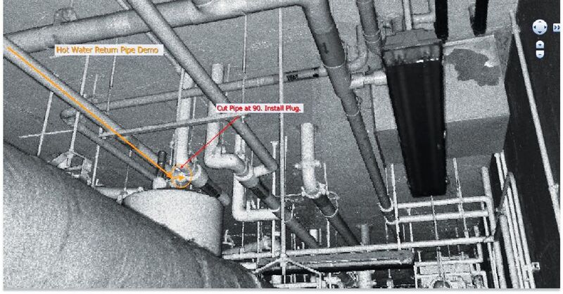
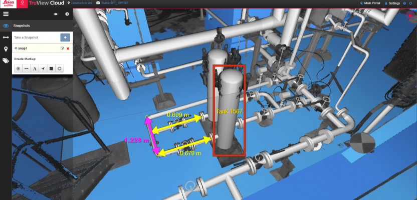
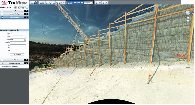
Users can mark up 360º digital panoramic images and readily share mark-ups with other project participants. Underlying coordinates for each pixel also enable distance measurements within the image. Credit: Joseph J Henderson & Son, Inc.Rich, new deliverables are changing client expectations for the better.
Underlying spatial coordinates and software features further enable users to easily take distance measurements between points, pan/zoom, add and share annotations for any parts of the scene, and even access links for specific parts of the scene to other content, such as pdfs, models, websites, other images, etc. Proposed design models can also be inserted, providing compelling previews of how a proposed design will look in its real-world setting.
To navigate among a collection of these images for a site or structure, users simply look at an accompanying digital map (typically a plan view) that shows icons for each location from which laser scans were conducted. Clicking an icon brings up the 360º digital panoramic image from that location. Users can hop from one icon to the next on the map or hop to icons visible within a 360º digital panoramic image itself.
The best way to truly appreciate this deliverable is to look at vendor and service provider examples online:
Value to Clients
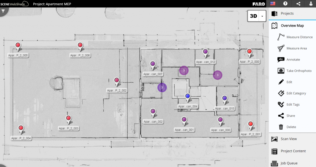
Clicking on an icon in a plan overview map opens a 360° digital panoramic image based on 3D laser scans and photos taken from that icon location. Credit: Faro
First, this deliverable is very rich compared to traditional 2D or 3D deliverables. Details are visible and measurable that are simply not available in extracted models or maps. Many clients feel they’re getting more for their money.
Clients value the virtual presence at the site/scene/structure. I can’t tell you how many times I’ve heard users glowingly say, “It’s just like being able to do a walk-through of a site [or scene, building, plant, ship, etc.] without having to travel there!”
Clients also value the ability to take measurements themselves between any points in an image—without having to be at the site.
The deliverable is intuitive to use. You don’t have to know how to interpret survey maps or engineering drawings, use CAD, or use 3D software. If you can use Google Street View, you’re good to go. Measurement and annotation tools are likewise intuitive.
Clients also like that no special software is needed (users just click on a URL), or the needed software is free.
Finally, this type of deliverable can also be readily shared with others via the Web, which is particularly valuable for projects with multiple and/or remotely located participants.
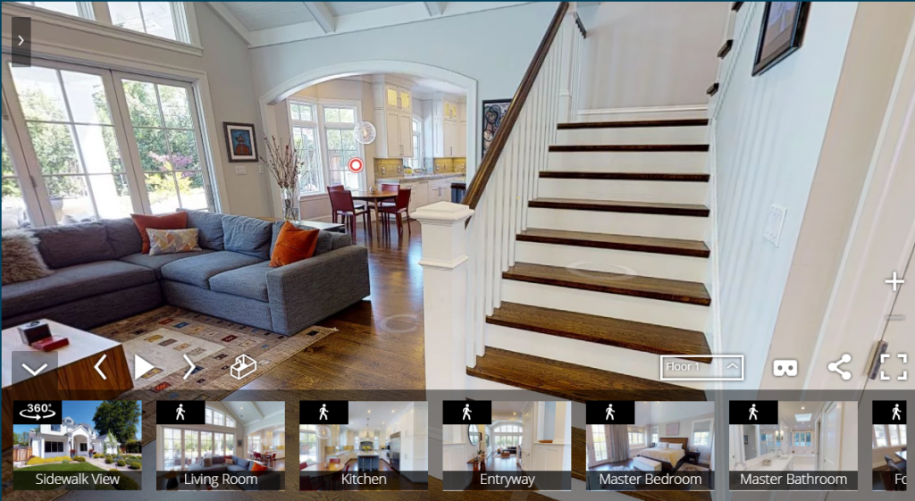
Matterport has fine-tuned online home walk-throughs for realtors based on 360° digital panoramic images with underlying geometry. Credit: Matterport.
Value to Surveyor/Service Provider
In addition to making clients happier, the deliverable demonstrates the high degree of detail that a surveying/reality capture service has captured, thus communicating an overall higher value service. It also reinforces a service provider’s claim that return visits to a site can be reduced.
Since this type of deliverable is so intuitive to use, a client’s boss can use it. And the boss’s boss. And the venture’s financial partner. Any project stakeholder can use it and get value from it. As a result, the client audience is often greatly expanded. Some organizations today have literally hundreds of staff who use this type of deliverable regularly. It’s become a standard deliverable for crime cases because it’s intuitive for juries, as well.
360º digital panoramic images with geometry are provided daily to staff monitoring the repair status of a major dam in Northern California. Credit: R.E.Y. Engineers, Inc.
In practice, office CAD techs and modelers also use 360º digital panoramic images to aid map-making and modeling, even when that deliverable isn’t provided to a client! They’re more intuitive and easier to interpret than just point clouds, and they help office techs ensure they’re not missing something when modeling or mapping.
When surveyors and service providers start providing this type of deliverable to clients, I often hear, “It’s an excellent communication tool.” Having the same virtual site presence on both the service provider and client side—along with annotations—helps avoid miscommunication on projects.
Finally, the deliverable is quick and easy to create and deliver. Special “publishing” software is needed to create them, but the creation process is quick, so 360º digital panoramic images are often the first deliverable provided. Moreover, they’re often provided at a nominal cost or are a “free extra” to clients, along with standard deliverables.
Delivery Methods
There are two common delivery methods. One is via file sets on data storage devices (e.g. external hard drives, DVDs, etc.), often a required delivery method for forensic agencies based on evidence-handling requirements.
Web portals are another popular delivery option. Portals tend to be used for projects with large numbers of scans and/or many stakeholders. They can be developed in-house and hosted by surveyors/service providers. Some organizations use web portals internally for sharing 360º panoramic images on large projects.
Software for setting up this type of portal is also commercially available (e.g., uGRIDD); such portals can also conveniently share other related content, (i.e., videos, maps, GIS, and cadastral data).
Another portal option is via third-party portal service providers (typically laser scanning product vendors) that use the cloud (e.g., Amazon Cloud). Using a cloud service hosted by a third party eliminates the need to use in-house IT staff to set up a server/hosting infrastructure.
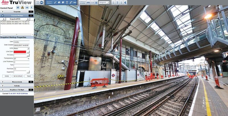
Distance measurements can be taken between any points in this 360º digital panoramic image of a rail station. Credit: ABA Surveying.
Projects Where It Shines
This type of deliverable first took off for industrial plant projects, where a virtual site presence proved extremely beneficial for design staff and others who may rarely step foot in the actual plant.
Other common applications include building interiors, MEP, complex infrastructure and sites, heritage and crime scenes: typically scenes/sites with “good 3D geometry” (i.e. plenty of vertical content).
Extending the Virtual Presence Benefit
The popularity of this type of deliverable has led to its further development. For example, 360º digital panoramic images can be created for mobile scan data or from any location within a registered point cloud, not just where a static scanner was set up.
Of note, Matterport has fine-tuned the presentation of high resolution panoramic HDR imagery and underlying 3D geometry data into truly stunning walk-throughs of building interiors. Matterport’s solutions are used today by realtors for marketing high-end residential properties online.
Matterport variants are also suited to commercial building projects, as recently underscored by an agreement with Multivista for applying the walk-through visualization software to construction site documentation.
Clients: “I Want That”
In virtually every case that I’m aware of where clients have been exposed to this type of deliverable, clients typically insist on it going forward. It has, for many clients, already become a standard, and it’s on a path to set a broader, overall standard in client expectations for the whole market.
Image at top: Proposed designs can be reviewed in context by spatially inserting them into 360º digital panoramic images. Credit: Leica Geosystems.
To read more from this print issue, click on the cover below.