“You can’t change nature… But nature IS change!” – Remy in Ratatouille
For decades climbers have struggled with the physical and technological hurdles of measuring the Earth’s highest mountain peaks. Now they’re turning to survey-grade GNSS equipment to measure extraordinary heights.
 It may surprise you to learn that the majority of the world’s mountains do not have official, recorded heights. Debate still swirls around the true elevation of even Mount Everest, which has long been accepted as the world’s highest mountain. Nepal stands by the measurement of 8,848 meters (29,029 feet), the result of a 1954 survey; China refers to the mountain as 8,844 m (29,016 ft) from its 2005 expedition; and the U.S. Geological Survey (USGS) lists a height of 8,850 m (29,035 ft), a measurement taken from GPS recordings collected by a National Geographic Society-sponsored American team in 1999.
There are many reasons for the lack of definitive numbers. One is that there is no officially designated international body to oversee summit measurements or to sort conflicting elevation claims. Two: summit expeditions require hefty financial support. Three: a successful ascent does not guarantee that an expedition team can locate the highest exposed rock for accurate measurement. Four (perhaps the most notable reason): measuring mountains is literally an uphill battle; for mountaineers, a good day at the office is returning alive with all their fingers and toes.
Nevertheless, that lack of knowledge seems incongruous to the instant information gratification expected today. Against the backdrop of today’s technology-driven society and Web-based information “drive-throughs,” where search menus order up customized bits of information in a few clicks, it is perplexing that a mountain’s summit elevation could be in dispute or even unknown.
 “I was amazed myself that we don’t know the exact height of some of these mountains,” says Damien Gildea, an Australian mountaineer, author, and explorer who has climbed for more than 15 years. “With the amount of information and technology today, like in-car GPS, it amazes people that we don’t know the exact height of some of the world’s mountains; even up until 2002 we didn’t know for sure what the three highest mountains in Antarctica were. But with the improved accessibility and quality of GNSS we are gaining a much better perspective and understanding of the world’s mountains.”
Since the well-publicized ascent of Mt. Everest in 1999, the use of GPS technology to measure mountains has been rising steadily to the point where it is now as commonplace on expeditions as ropes. Partly fueled by national self-interest—the ability to lay claim to the highest mountain in the world or in a region can be a source of national pride—and the heightened interest by research and scientific organizations and geographic institutions to improve our map of the world’s summits, GPS technology has been showing up on mountains on nearly every continent on the globe. Gildea has taken GPS technology to Antarctica’s mountain ranges eight times. The technology was a critical component of one of the most recent expeditions to Mt. Everest in spring of 2012 to both re-measure the still-growing mountain and determine the composition of the rocks on the summit pyramid.
Taking GPS to New Heights
To be sure, the GPS technology being used for officially sponsored measuring expeditions is not the consumer-grade type embedded in wristwatches, smart phones, or retail handheld receivers. Similar to land surveying requirements, capturing accurate summit elevations requires professional-grade, advanced GPS/GNSS receivers and base stations that are data-processing solutions capable of transforming the data into precise measurements.
Perhaps most critical to this expedition trend is that climbers are equipped with small, user-friendly systems that can withstand the unpredictable elements. “We’re climbers, not surveyors,” explains Gildea. “We need a simple, lightweight system that we can carry to the top of a mountain. It’s going to be -33º Fahrenheit (-36º Celsius), so we need to be able to operate it with gloves on. And it needs to have batteries that can last more than six hours. All of that simplicity needs to be built in from the start to ensure we can successfully operate the GPS equipment without needing to be a trained, professional surveyor first. Because once you’re on the mountain, there are too many things that can go wrong, and your own personal safety comes first.”
 Having climbed and led expeditions in Antarctica, Nepal, Tibet, Pakistan, Bolivia, Alaska, and New Zealand, Gildea has had his share of experience in using GPS and in seeing things go wrong. For his debut GPS expedition to Antarctica’s Mt. Shinn in 2001, for example, unsafe conditions forced him and his colleague off the mountain. However, they were successful one year later, setting a Trimble 5700 GPS receiver on the summit and recording a new height of 4660.50 m (15,290.35 ft)—a solid 140 m (459.32 ft) lower than the previously estimated height of 4800 m (15,748 ft) from 1960—establishing Mt. Shinn as the third-highest mountain on the continent.
The Mt. Shinn expeditions were the first of Gildea’s eight Antarctic ascents sponsored by the former Omega Foundation in an effort to improve the geodetic map and knowledge of the remote Sentinel Ranges of the Ellsworth Mountains. Over a seven-year period, Gildea used GPS technology to measure some of the continent’s highest mountains, including Mt. Vinson (tallest), Mt. Craddock, Mt. Gardner, and Mt. Epperly, as well as mountains on Antarctica’s Livingston Island.
The GPS ascents not only helped to bring height order to the continent’s well-known mountains, they also put a new mountain peak on the map: Mt. Rutford, a peak that previously had no name and no known elevation. Intrigued by a high peak Gildea spied while standing on the main summits of Mt. Vinson in 2004 and Mt. Craddock in 2005, Gildea’s team climbed to its top in 2006 and measured its height as 4,477 m (14,688 ft), establishing it as the highest point on the Craddock Massif.
The high-precision GPS data collected by Gildea and his team has helped create better maps of the region, including Gildea’s own published 1:50,000 topo map of the Vinson Massif and Sentinel Range in 2007. And it has put Gildea himself on the map of Antarctica. In 2006, the Advisory Committee of Antarctic Names officially named a 10-km-long (6.21 mi) glacier flowing southwest from the Craddock Massif the Gildea Glacier.
Everest’s Allure
In contrast to some of the Antarctic mountains that have been climbed only a handful of times, Mt. Everest has been belayed and trodden by thousands. According to a May 2012 report by the Associated Press, more than 3,000 people have climbed Everest since Edmund Hillary and Tenzing Norgay became the first to do so in 1953. And since the first recorded attempts in 1922 to stand on the top of the world, 233 people have died, according to a May 2012 article in the Guardian newspaper—10 fatalities alone in 2012—and many of their bodies still rest on the mountain, serving as chilling reminders for those who risk their lives after them.Considering how high the odds are of not surviving “the death zone,” the number of Mt. Everest climbs is remarkable. Myriad issues can challenge expedition teams from the start, but once climbers reach 8,000 m (26,000 ft), they face significant challenges of survival: temperatures can dip to -33º F (-36º C); hard-packed snow or bare ice can cause fatal slips or falls; high winds reduce visibility; and the low atmospheric pressure can notably slow the pace—it can take up to 12 hours to walk slightly more than 1.7 km (1 mi). And yet, the mountain still lures hundreds of climbers each year.
Part of that intrigue is held by the geographic and scientific community that has been interested in the height of the mountain since the Qing Dynasty (1644 to 1912). From 1847 to 2005, more than 10 surveys were performed to measure Mt. Everest’s height. In 1852 Indian mathematician and surveyor Radhanath Sikdar was the first to identify Everest as Earth’s highest peak using trigonometric calculations from theodolites 240 km (150 mi) away in India. In 1955, an Indian survey again used theodolites to measure the summit at 8,848 m (29,028 ft), an elevation that was reaffirmed by a Chinese measuring expedition in 1975. In 1999, the American Everest Expedition set a GPS unit on the snow summit to obtain a height of 8,850 m (29,035 ft). And in October 2005, China sent a team to re-measure the mountain on the 30th anniversary of their first survey. Using Trimble GPS, theodolites, and other measuring equipment, the team determined Mt. Everest’s peak to be 8,844 m (29,017 ft), an elevation the Chinese claim is the most accurate to date because the height is based on the actual highest point of rock, not on the snow and ice covering it.
However, the mountain’s height can only ever be defined at a moment in time. “Mt. Everest is part of a dynamic tectonic environment created by the collision of India with Asia, and this collision is still on-going today,” says Dr. David Lageson, a structural geology professor at Montana State University (MSU) in Bozeman. “We know that Mt. Everest is still rising at a rate of about a third of an inch every year and moving northeast at a rate of about three inches a year.
“What we aren’t as sure of is the mineral composition, strain, and age of rocks that comprise the four-mountain Everest massif—most of the rocks above 6,000 m (19,685 ft) on Everest have not yet been directly studied—or how and when the major faults that cut through the mountain were formed.”
When Lageson was offered the opportunity to personally explore Everest in March 2012 and gather samples in a quest to answer these and other geologic questions, he eagerly accepted. Lageson would be leading a significant scientific mission, and he would be accompanying a team of climbers aiming to make mountaineering history.
An Everest Education
Sponsored by The North Face apparel and equipment company in partnership with National Geographic, the National Science Foundation, and MSU, the historic expedition was designed to commemorate the 50th anniversary of the first successful American ascent of Mt. Everest. Led by professional alpinist and author Conrad Anker, some members of the 11-person team aimed to retrace the steps of the first American ascent of Mt. Everest via the difficult West Ridge, one of the most punishing high-altitude feats in mountaineering history that has not been repeated since 1963.
Lageson’s objectives for this Everest Education Expedition (EEE) were to both re-measure Everest’s current, highest peak with GNSS technology and to collect rock samples from the base camp to the summit to better understand the age and geology of the tallest Himalayan mountain—discoveries, insights and high-altitude adventure that would be beamed into classrooms across Montana and the nation.
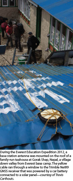
Soon after setting up base camp at about 5,243 m (17,200 ft) above sea level near one of the peripheries of the Khumbu Glacier, Lageson and his geology team focused on establishing geodetic control for the GNSS summit survey and geological research. They set a Trimble NetR9 GNSS base station on the only place with continuous electricity—the roof of a tea house at Gorak Shep about 4.5 km (2.8 mi) down valley from Everest base camp.
Then for nearly two months prior to “summit day,” Lageson and geology graduate student Travis Corthouts methodically explored the region’s geology as they followed the climbing team’s phased ascents to the summit. (Typically Mt. Everest climbs require teams to establish four ascending camps on the mountain to enable them to acclimatize, rest, store supplies, and prepare for the next leg of the ascent.)
At base camp, Lageson and Corthouts explored the Khumbu Glacier, where they found leucogranite rock, a white-colored igneous rock that is about 22 million years old. Using two Trimble GeoExplorer 6000 series handheld receivers, they recorded locations of specific finds and collected rock samples for further analysis. They also used the GNSS receivers to monitor and measure the pace of glacier movement at different locations near base camp.
Identifying suitable, sizable granite boulders at both base camp and on the central Khumbu Glacier, they used the GNSS to measure the boulders’ movements over a two-week period. In that time, the granite boulder on the central glacier moved 2.8 m (9.2 ft)—indicating rather rapid ice melt—whereas the boulder at the glacier’s periphery moved half that distance. In all, Lageson’s team collected about 30 samples of varied rock, from the leucogranites near base camp to the fossilized sedimentary rocks near the summit, all of which will serve as stepping stones to greater Everest understanding.
“We probably retrieved one of the most complete suite of rock collections ever to come off of Mt. Everest,” says Lageson. “And having sophisticated, robust, and high-precision GNSS equipment was critical to our research. The handheld technology gave us the mobility and precision to easily locate our positions and our sample locations, and that information, plus the rocks themselves, will greatly aid us in our analysis of Mt. Everest’s history.”
Lageson and Corthouts’ personal geological investigations reached 6,706 m (22,000 ft), a journey requiring them to traverse the ominous “Khumbu Icefall,” an ancient glacier that can have ice as deep as a 12-story building, where Anker’s team set up Camp 2. From there, the Sherpa support team would carry the GNSS equipment to the summit and collect the higher-elevation rock samples.
Extending the Education
In addition to the field work carried out on Everest, Montana State University’s David Lageson led the EEE’s education outreach program—one of the most successful components of the expedition, says Lageson.
Also sponsored by the NSF’s Montana EPSCoR (Experimental Program to Stimulate Competitive Research), the program was designed to bring the global adventure and science of the expedition to classrooms and invite students to learn with them. Through lesson plans, videos, interactive Web features, and dispatches from the team on Everest, students in grades 5-9 followed the expedition in real time, learning more about the relationship between the Everest region and the Northern Rocky Mountains.
MSU’s Extended University created 8 lesson plans, 11 customized science activities, 38 teacher kits with 8 supplemental activities, a Facebook page, and a website offering videos, multimedia, and interactive elements. Thousands of students across Montana and the country followed the expedition, including schools in Oregon, California, and Florida.
Other highlights include:
- 38 schools (36 in Montana and one each in Wyoming and Utah) received teacher’s kits, each with approximately $500 worth of equipment, including a GPS unit, a time-lapse camera, maps, a pulse oximeter, rock samples, climbing gear, maps, and a weather station.
- More than 2,000 students used the teacher kit materials.
- Students across Montana measured local summits with GPS while collecting rock samples and making scientific observations.
- There were nearly 10,000 visits to the unique EEE website, including visitors from Canada, Belgium, the UK, India, Australia, Germany, and the Netherlands.
To the Top
Anker was due to make the historic climb up the West Ridge in mid-May; however, on the scheduled day to ascend, he had to cancel the climb because of poor conditions on the West Ridge. But fewer than 10 days later, he joined his other climbing colleagues taking the more common Southeast Ridge route.
On the magical, early morning of May 25th, the team of five climbers and two Sherpas reached the summit, 55 days after first arriving in base camp. However, horrendous winds threatening frostbite, combined with the hordes of people on the mountain that day, made the placement of the two Trimble R8 GNSS receivers quite challenging. One Sherpa set the R8 receiver, which was mounted on the top of a 1-m-long (3.3-ft) carbon fiber pole, on bedrock about 3 m (9.8 ft) vertically down from the summit and recorded data for one hour, while another Sherpa began his descent to collect rock samples.
Although the measurements were not taken from the exact summit, preliminary analysis of the data indicated an elevation of 8,846 m (29,021 ft)—only a few feet off previous recorded heights. Considering the conditions on the mountain that day, the off-summit recordings were testament to the tenacity and fortitude of these experienced mountaineers.
“There were only a handful of summit window days favorable for a climb to the top,” says Lageson. “So our team, carrying extra GNSS equipment, had to contend with dozens of other people all climbing the same route, at the same time, in extreme high-wind conditions. Despite all of that, the team made it to the top, and Danuru Sherpa and Jangbu Sherpa did the best they could to place the GNSS receiver on such a crowded summit. An Everest expedition is an extremely complicated equation of skill, risk, and luck.”
Measuring mountains does indeed require climbers to walk that very tenuous line between the need to know and the risk to one’s life. However, as mountains continue to rise to new heights, so too will mountaineers endeavor to measure them. Gildea, in fact, is already preparing his GNSS technology for his attempt to measure Heard Island’s Big Ben in 2014.