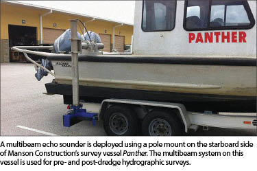
How can you add a multibeam system to your hydrographic survey operations? A company that provides equipment and integrates systems for marine positioning and survey products explains the priorities and steps.
The hydrographic surveying industry continues to evolve its instrument technology. Project plans that used to be dominated by single beam echo sounders and DGPS have now been complemented, if not superseded in many instances, by multibeam echo sounders, RTK GNSS, and extremely accurate motion compensation. These enhancements have been emerging at the same time that land surveyors and marine contractors—who previously may have stayed out of hydrographic survey applications—have chosen to add this type of service to their portfolio.
To understand this progression, it is helpful to look at what these technologies are capable of. Deployed on a boat, a single beam echo sounder emits a conical acoustic (sound) pulse. The acoustic pulse reflects off the bottom surface material and is received by the echo sounder. To calculate a depth, you combine the time it takes for the pulse to be transmitted and received with the velocity (speed) of sound through water.
When integrated with a GNSS receiver, a single beam system can provide X, Y, and Z coordinates for each data point. Multiple survey lines are collected over the desired area, and these lines of data points can then be interpolated to create a digital elevation model (DEM) of the bottom surface.
Single beam systems are relatively easy to learn, and they integrate well with existing GNSS equipment and small boats. They are affordable to acquire, and many firms use them to support their terrestrial applications whenever they need to survey a body of water adjacent to their project site.
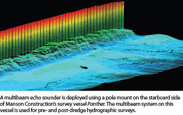
A multibeam echo sounder also emits an acoustic pulse. However, its pulse is wide across the track of the vessel and narrow along the track. When a multibeam acoustic pulse returns from the bottom surface, it is divided and recorded as multiple returns (data points), typically from 120 to 256 depending on the type of system. So, a multibeam can generate a swath of 256 data points per ping, while a single beam system generates 1 data point per ping. A multibeam system is capable of providing total ensonification of the bottom surface so that very little, if any, interpolation is required to create a DEM.
 This comprehensive data has increased the scope and scale of what surveyors and marine contractors can now provide as underwater as-built surveys and site analysis. In many cases, the point distribution on the bottom surface can be similar to that of a terrestrial lidar point cloud in terms of spatial density. To obtain this valuable type of data, multibeam systems demand high-precision positioning, heading, and motion compensation tolerances. Surveyors who have traditionally worked in hydrographic surveying have been able to match their understanding of these systems over the years as the technology has progressed. For surveyors or firms that have had little experience with hydrographic surveying but see the value in adding this capability, determining how to acquire and use a multibeam system can be challenging. There is a learning curve for the type of equipment needed as well as required training. This article is for these “new multibeamers.”
As an equipment provider and systems integrator of marine positioning and survey products, Measutronics Corporation has worked with organizations from all types of backgrounds. Here we describe the fundamental steps for how to add a multibeam system to your hydrographic operations.
Step 1: Define Your Deliverable
When you’re determining what type of equipment you will need, make sure you know what type of data or mapping product is important to your clients. Lou Nash of Measutronics says that one of the first questions he asks customers is, “What are you trying to accomplish?” Nash says, “From there we start to get into their project requirements and tolerances.”
 A multibeam system is comprised of many sensors that should meet the project specifications you plan to encounter. For instance, high-order surveys for the U.S. Army Corps of Engineers and thematic maps for fish habitats have extremely different demands.
Step 2: Look at Your Resources
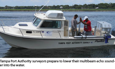
Historically, single beam surveys could often be carried out on a small skiff with only a single operator. Many multibeam applications typically require larger boat platforms and at least two people, one as the system operator and one to drive the boat.
There can also be a significant capital investment involved, so make sure you will have enough projects and cash flow to keep this part of your business going. Budget limits for what can be allocated to this type of investment should be balanced against the error budget you are comfortable with.
 Note that project-centric equipment investments can backfire. For instance, choosing a less-accurate multibeam sonar initially to meet budget requirements then discovering that it is unable to meet future project accuracy tolerances can cost you more money in the long run. Alternatively, choosing a lower-cost GNSS receiver that can be upgraded in the future to higher functionality can help you meet your current budget while protecting your investment for the future.
Step 3: Choose a Multibeam Sonar
When choosing a multibeam sonar, consider these factors.
Frequency: Typically multibeam sonar frequencies range from 200 to 400KHz, and some systems provide the flexibility to adjust the frequency on the fly within that range. In general, a higher frequency correlates with higher resolution of the bottom surface. The inverse is true of frequency and depth range. The ability to select different frequencies can be important to avoid interference with other sonars or underwater noise that may be present in the surveying area.
Beamwidth: The width of the multibeam acoustic pulse is important for resolution. Beamwidth is specified as an opening angle that the beam will continue to diverge (expand) from the deeper it goes. The larger the beamwidth, the larger the footprint it will ensonify on the bottom surface. This translates to lower spatial resolution of bottom surface features.
Ping Rate: Described in Hertz (Hz), the ping rate refers to the number of acoustic pulses transmitted per second. A higher ping rate translates to a higher number of data points per second.
Range Resolution: The range resolution specification refers to the raw precision of the acoustic pulse. Higher resolution provides increased ability to distinguish between features that are close together.
Number of Beams: This refers to how many data points are returned from one acoustic pulse.
Step 4: Choose a Motion Sensor
 A multibeam system must have a motion sensor to account for the motion of the boat during operation. Typically these systems measure heave, pitch, roll, and yaw. Some of the advanced inertial sensors have the ability to provide positioning during a GNSS outage.
Positional Accuracy: If a sensor has inertial positioning capability, what are the accuracies that can be achieved while aided by GNSS as well as during a GNSS outage?
Roll and Pitch Accuracy: This refers to how accurate the pitch and roll angular measurements are in degrees.
Heading Accuracy: This refers to how accurate the heading or yaw of a sensor is in degrees. Heading, roll, and pitch accuracies are important factors in the final position error budget.
Heave Accuracy: This refers to how well the sensor can measure vertical displacement.
Step 5: Choose a Positioning Sensor
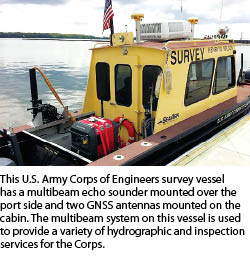
Typically this will be a GNSS rover receiver with heading capabilities (two antennas). RTK is recommended, but DGPS may be used as long as you can provide vertical control with a tide or water-level gauge.
 GPS or GNSS: Does the receiver use GPS only or is it capable of using other GNSS such as GLONASS?
DGPS or RTK: Does the receiver accept single-frequency sub-meter differential GPS or dual-frequency centimeter-level real-time kinematic corrections?
Output Format: Does the receiver output data in National Marine Electronics Association (NMEA) format through standard connections such as RS-232 or ethernet?
1PPS Output: Does the receiver allow for one-pulse-per-second output to aid in synchronizing other sensors in the system such as the multibeam sonar and motion sensor?
High Update Rate: Can the data be output at high update rates to keep up with the dynamic motion of the boat?
Ability to Output Precise Heading: Can the GNSS receiver provide an NMEA precise heading output?
Step 6: Additional Sensors and Equipment
Additional sensors for a multibeam system may include a real-time sound velocity sensor for the sonar head, a sound velocity probe for determining the sound velocity throughout the water column, a solid multibeam sonar mount on or in the boat, and a computer capable of processing large amounts of data and graphics (such as video).
Step 7: Software
Hydrographic acquisition software programs integrate the above sensors into a common platform to record, clean, and process data into numerous formats and outputs. They should operate on computers with high processing and graphics capabilities.
Step 8: Installation and Training
Manufacturers provide training on their specific sensors, but we recommend you have help from someone competent with all of the sensors involved—especially the software and integration of so many equipment components—so that the system is properly set up and calibrated. Training should be provided directly after installation so that your system operator(s) will understand how the system was set up, the proper way to use the system, and other helpful troubleshooting information.
The investments in these technologies can be steep, so we recommend allocating the proper resources for installation and training. Consider the costs when you look at purchasing a multibeam system. Investing in a quality skill set for your employees will pay off in terms of operating efficiency.
Many organizations send their operators to a multibeam training class before they begin to look at purchasing equipment. This can provide an in-depth overview of what it takes to operate the system and can be a good forum to ask other hydrographic surveyors their thoughts and recommendations.
A manufacturer’s representative or distributor may also provide comprehensive installation and training because they may work with many of the various types of sensors involved instead of just one. This can be extremely valuable later if you need technical support for the system. These steps should provide a good foundation for deciding how to get into multibeam surveying.
