A surveying firm based in the United Kingdom leverages its terrestrial 3D scanning and modeling expertise into a new market: marine and shipping applications.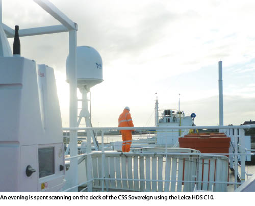 In February this magazine showed how Fenstermaker and Associates expanded their firm by successfully employing “Diversification through Scanning.” Now we take the idea another step to a firm with extensive 3D scanning experience that is leveraging it into new markets.
Shrewsbury, UK-based Severn Partnership is made of chartered land surveyors with more than 30 years of experience providing a wide range of geospatial services worldwide. Along with land survey and geomatics services, they handle a robust array of projects using 3D laser scanning technology and 3D modeling software, including railroad infrastructure projects. Like Fenstermaker, they too wished to widen their business via diversification. In Severn Partnership’s case, they managed to bring their 3D scanning and modeling experience and technology into the arena of ship scanning. For details about how, we talked to Nicholas Blenkarn, BSc, MSc, MRICS, MCInstCES, director of Severn Partnership.
Professional Surveyor: I understand Severn had a unique, speculative approach to diversifying into the field of 3D laser scanning and 3D modeling for marine and shipping applications. Can you tell us more about that?
Nicholas Blenkarn: We took a cue from Winston Churchill who noted that, “A pessimist sees the difficulty in every opportunity; an optimist sees the opportunity in every difficulty.” We had a desire for business diversification and saw laser scanning as a good place to start, given our complement of transferable skills and deliverables. Our skill-set, derived from tight deadlines and high-accuracy scanning in limited time slots, seemed perfect for the marine industry.
However, the obvious stumbling block is having a case study project to show sector experience. Our solution was simple—to go get it rather than waiting for the project to come to us. Our next step was to find contacts, request access, obtain safety briefings, and finally get scanning in dry dock.
Whenever cost is taken out of the equation, there is more willingness to say yes. With a sample scan in the bag, we were then able to extol the virtues of reality capture through terrestrial laser scanning compared to conventional techniques. 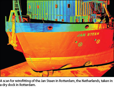 PSM: What are some typical end-use applications for your clients in this field?
NB: A variety of applications, all with comparative deliverables by conventional techniques, from computing the 3D position of radar and GPS equipment on “monkey island” [the flying bridge on top of a pilothouse or chart house, also known as the ship’s upper bridge] relative to the ship’s axis and baselines to 3D modeling from the cloud for use in 3D navigation software.
Laser scanning is also ideal for plant and structure retrofitting, where, for example, HVAC equipment or new engine parts are being added and architects must check for clashes and plan retrofit in a tight and complex 3D environment.
Change of use is another key deliverable—where large vessels are fitted out for new purposes. A 3D scan and model allows naval architects to complete detailed structural design and also to maintain records ready for putting the ship back to its original condition post-project (which could be years later).
Another ideal use is for ship hull strike investigation—cutting down the time to observe hull damage in 3D to less than an hour once the scan team is on site. Points are observed at three-millimeter spacing to allow detail sectioning of the damage. This data can then be used assessments for speed and angle of blow. 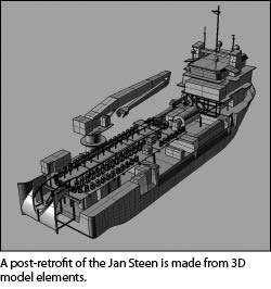 PSM: What types of laser scanners and scanning/post-processing software do you employ?
NB: We use Leica scanners for a robust, well-supported solution capable of working in a range of conditions, currently HDS C10 (time of flight) and HDS 6100 (phase) scanners. Post-processing is completed within Leica Geosystems Cyclone software for cloud-to-target and cloud-to-cloud registration.
PSM: What are typical deliverables you provide your clients?
NB: A standard deliverable would be the cloud in Pointools “POD” format for free-to-use point cloud visualization, but also in “PTX” format to enable archiving of the cloud in a format accessible to a number of platforms. After that, the deliverables could also include derived 3D models complete with unwrapped textures (Ogre texture maps) and rendered images created in 3D Studio Max.
Critical dimensions around the ship are often required, along with clearances and alignments that can easily be derived directly from the cloud.
PSM: What are the typical challenges you encounter in these projects?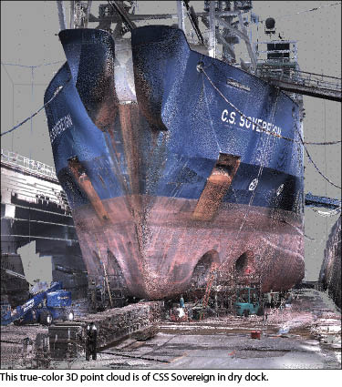 NB: There were numerous challenges—as with any industry sector, scanning ships is not without its difficulties. These can range from the logistics of catching a ship in dry dock for a tight window of two to three days (time in dock is costly) to extremes of wet and cold weather, testing the robust operation of the equipment. Avoiding the “snap zone” of failing mooring ropes under tension is a must for health and safety, along with the associated slips and trips of a busy working ship.
Survey equipment wise, be careful to plan surveys around active engine compartments: Ships’ engines tend to be kept running 24/7 to keep essential services operational. This can lead to engine vibration which could affect both the accuracy of scanned points and the ability to acquire control target observations—scanning from a distance is the only option, so terrestrial is better than phase in this situation.
For some locations, with our C10 scanner the internal compensator can be turned off to scan without it. This can help with minor movements, ensuring there is a robust solution for point cloud registration to cope without it.
Lastly, check that your company’s professional indemnity and employer’s liability insurance covers you for marine work—it may not be covered as standard.
PSM: Can you discuss a typical ship-scanning project in broad strokes?
NB: As an example project, set a control grid and chose a target registration methodology (either controlled by total station target observation, common targets, or C10 internal traverse observations). Scanning the hull, decks, and external areas for a ship up to 170m-long takes approximately two full days for a team of two (with a pre-agreed point density and level of detail for extracted 3D objects in the job specification). After point cloud registration in Cyclone, for a large ship, external modeling can take up to three days to correctly define the surface of the hull and all required deck and superstructure features. Next comes detailed texture mapping from on-site color photography to record the colors and textures used to render the models in visualization.  PSM: Can you explain your cooperative process when working on projects in areas far from your home base?
NB: If schedules are tight and staff are not available, then having the site scanning completed by a trusted partner is the best option. Through networking at SPAR Houston and Leica HDS conferences in Las Vegas and San Francisco, we have a network of other professional companies we have called upon to help get the job done. This has been either with our direct control supervised by one of our senior team or by quality checking the cloud in post processing and modeling. This has enabled us to complete surveys as far afield as Honk Kong Harbor for marine work and the Ryder Cup golf course at Valhalla, Kentucky.
Lessons Learned
Having spent a great deal of time in technical marketing, I am impressed with Severn Partnership’s diversification approach. Land surveyors who employ 3D scanning as part of their service set, or those looking to add this capability, can take a lesson from their model. Be creative in your selection of new markets and applications by leveraging your existing experience, expertise, and technology. Then be bold in your tactics; note how they gained vital experience using a speculative approach. With this experience and sample data in hand they employed a “show and sell” strategy when working with potential clients.
Don’t stop there; once you have a toehold in a new market, you can look around for related applications in the same sector and leverage your newfound experience to further diversify your capabilities and thus, enhance profitability.