Adapted from the academic paper, “Arctic Charting and Mapping Pilot Project 2: Sharing Modern Technologies and Resources towards a Common Goal”, by Andrew Leyzack and summarized by Steven Keesee, with a history sidebar by Jeff Salmon.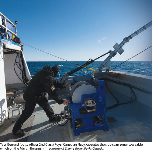 In April 2011, multiple organizations in Canada launched an initiative to focus and evaluate a multidisciplinary approach to mapping and charting in Canada’s Arctic. A small portion of the historic Northwest Passage—the Victoria and Alexandra Straits—was selected as the area to be mapped. Here, expertise in hydrography, archaeology, ocean technology, space technology, and environmental science was coordinated to capture, analyze, and publish data from various ocean-going, airborne, and space-borne platforms.
Large areas of Canada’s Arctic waters are inadequately charted, posing a serious threat to safety, the environment, and economic development, while forming a critical gap in the northern transportation infrastructure. The vast, isolated, and harsh environment of the north, in combination with limited resources, has resulted in the slow advancement of modern Arctic charting and has necessitated innovative approaches to overcome the challenges.
One of the primary goals of the project is to examine the feasibility of collecting data for the production of official navigational charts in the Arctic while supporting archaeological studies, coastal zone mapping, and ecosystem and habitat management objectives through a multi-platform, multi-sensor, and multi-organizational approach to surveying, data management and assimilation, and product generation. This multidisciplinary approach to data collection has thus far served to be a cost-effective means towards developing data holdings and products to support many other scientific activities in the Arctic.
 The confluence of Victoria and Alexandra Straits was chosen as the primary project area for the 2011 pilot project because it geographically satisfied the objectives of all stakeholders. The Strait, particularly the corridor, is usually the last area to be clear of ice in the summer months, and navigational “sea room” can be somewhat limited within the corridor. The area is rich with Inuit testimony of the fate of Sir John Franklin’s expedition (see sidebar), particularly the presence of Franklin’s ships HMS Erebus and HMS Terror. The sea area chosen falls within the theoretic drift trajectory from the HMS Erebus and HMS Terror’s last known position (southwest of Cape Felix).
Multiple Acquisition Technologies
One of the challenges of coordinating the various sensor platforms was fitting the appropriate technology to the areas to be surveyed. Where possible, lidar acquisition was conducted prior to sonar investigation so that the resulting lidar coverage would guide sonar operations into deeper waters—that’s where that technology would serve to acquire data more efficiently and effectively. A minimum International Hydrographic Organization (IHO, the intergovernmental organization providing standards for hydrographic surveying and charting) Order of Survey, Level 1 was maintained by integrating both single beam and side scan sonar for full-area search/target detection.
With experimental technology such as the interferometric side scan sensor payload (Klein UUV3500) deployed from the autonomous underwater vehicle (AUV), it was understood that, should the bathymetric swath deliverables fall short of charting quality, the team would at the very least obtain reliable nadir depth values combined with the side scan sonar coverage for IHO S-57 Category Zone of Confidence A2 from the UUV3500. 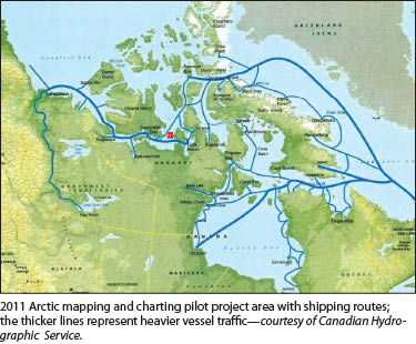 For sonar, two 7.9m Hourston Glascraft launches—Canadian steamship lines Gannett and Kinglett—were each equipped with an R2Sonic 2022, broadband multi-beam echosounder, a Klein 3000 dual frequency (towed) side scan sonar system, and Trimble-Applanix POSMV V5 – GNSS position and inertial orientation system.
For lidar, a King Air A90 aircraft was equipped with the scanning hydrographic operational airborne lidar survey (SHOALS-1000T). The sensor integrates 1000Hz (IHO Order 1) bathymetric laser with 1Hz digital downlook imagery.
Airborne lidar bathymetry’s greatest benefit is the speed it collects in shallow water (<30m) and that it delineates shoreline where traditional methods are not efficient or sometimes even possible. While other techniques and sensors could also map the near-shore areas, due to the limited seasonal window they could not likely map these areas before the season closes. Pre-planning the work significantly increases productivity.
Multiple Environment Hazards
The volatile Arctic weather conditions and local micro-climates present the most daunting challenge to an aerial operation in the Arctic. Having to balance crew safety with the pressure to complete the task at hand results in difficult management decisions. To mitigate this risk, several options can be considered. 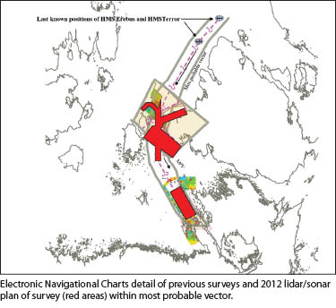 In any aerial operation, weather conditions of potentially three areas have to be considered. They are the departing airport, project location, and alternate airport. Current and forecast weather reports of these three locations have to be within tolerance levels to commence flight. If the work is relatively close to the operating airport, then this challenge is reduced.
With only one area of interest being focused on, the lidar aircraft and crew had to stand down when conditions for the worksite were not satisfactory due to weather or water clarity. Having options to choose from a number of potential sites to survey would be beneficial to increasing operational hours and reducing down time.
What would also help alleviate weather challenges would be having access to a ship as shelter for the crew and strategically located cached fuel at various airstrips in the Arctic.
To improve access to real-time weather information, remote meteorological stations or weather buoys at logical sites (i.e. a GPS base station, a central survey area) can be placed to report weather conditions via satellite, allowing the flight crew to make better informed decisions at a moment’s notice.
Although we did not implement this arrangement for the 2012 program, daily contact with Environment Canada for post-processed, near real-time satellite imagery in both optical and RadarSat deliverables proved to be indispensable tools for directing day-to-day operations based on visual assessment of water turbidity and ice concentrations. The collaboration with the crew of the Canadian Coast Guard Ship Sir Wilfrid Laurier for establishing and using GPS ground control greatly decreased the amount of pre-planning required to coordinate and maintain such a remote base station.
The operational success also required constant communications between parties. For example, communications were critical between the Canadian Hydrographic Service (CHS) representative located on the Canadian Coast Guard Ship and Fugro personnel at Gjoa Haven, Nunavut Territory. Operation daily briefs at designated times helped keep all local parties up to speed on events.
This called for great reliance on electronic communications, which, due to the work location, proved unreliable. The impact of limited communications was somewhat alleviated through the assistance from remote offices for expediting some data processing and coordinate derivation. A CHS representative with authority to make on-spot decisions, stationed with the project crew, will further alleviate the impact of unreliable electronic communications.
In 2012, a CHS project authority joined the lidar team based in Gjoa Haven for the first one and a half weeks of the survey. The resulting interaction provided a better understanding of both client and contractor expectations and the development of best-practice guidelines for Arctic lidar surveys.
Of further benefit to the management of the lidar field program was the introduction of a Broadband data and voice communications link aboard the Canadian Coast Guard ship where, upon transferring to sea operations, the CHS project authority was able to communicate with the lidar team ashore through robust email and ftp data exchange.
With the limited availability for work according to season, flight operations benefited from the addition of a second aircrew (two pilots and one operator) to take advantage of the extended daylight hours of the high latitudes in summer. When the weather and water clarity were positive, two flight crews were able to take full advantage of the opportunity and fly around the clock.
The timing for 2012 was also pushed up by three weeks to commence at the beginning of August. Then the frequency of poor visibility and low ceilings associated with low-pressure systems was less than during late August/early September 2011. The team observed many consecutive days of high pressure, bringing clear skies and generally stable weather conditions to most if not all of the project areas.
Multiple Successes
An immediate, tangible benefit resulting from the 2012 program was the reconnaissance and subsequent survey of an alternate shipping corridor joining Storis Passage with Victoria Strait via Alexandra Strait. The new corridor was widened to 0.8km with only a few transits with our survey launches. The new route provides a potential time savings of seven hours for vessels transiting the area west of King William Island.
Data from this pilot project serves those seeking to locate and protect archaeological artifacts within a geographic area of known significance to Canada’s marine heritage, and it could be invaluable for parties continuing to examine the history of the Franklin expedition. The project will provide data to support scientific analysis for seabed and coastal zone classification and to provide a comprehensive description of an Arctic coastal zone area for effective environmental protection and response.
Given the opportunity to obtain various types of coastal data outside of what has been traditionally hydrographic, it is anticipated the project will create further opportunities to develop innovative means of delivering data and information to users as well as lead the way towards implementing future multi-departmental/private sector collaborations in the Arctic.
This pilot project has contributed hydrographic, archeological, and coastal zone data towards the development a geospatial planning tool hosted by the Canadian Hydrographic Service. At the time of writing, the tool is serving as an aid to research various scenarios to establish a network of Arctic marine transportation corridors, part of the government of Canada’s contribution towards a world class tanker safety program.
Acknowledgements and Project Partners
In addition to the Canadian Coast Guard Ship Sir Wilfrid Laurier’s officers and crew, the lead author would like to acknowledge the cooperation of Andreas Lazda of MDA Corporation, John Birchmore of TeleSat, Yves Crevier of CSA, Mark Macdonald of Fugro Pelagos, Inc.
Project partners and participants include Fisheries and Oceans Canada, Canadian Hydrographic Service (CHS), and Canadian Coast Guard. The CHS, Central and Arctic Region coordinated logistics and directed data acquisition operations in collaboration with Parks Canada Agency-Underwater Archaeology Service. Also involved are The University of Victoria, Ocean Technology Lab, Canadian Space Agency, Environment Canada, Landscape Science and Technology National, Arctic Research Foundation.
Andrew Leyzack is a commissioned Canada Lands Surveyor and is currently serving as hydrographer-in-charge of western Arctic surveys. He is past president of the Canadian Hydrographic Association and is the Canadian Delegate to FIG Commission 4.
Steven Keesee is a utility and land surveyor in Washington State.
SIDEBAR
The Lost Franklin Expedition
The ill-fated Franklin expedition is a well known story in the Canadian north but perhaps less so to readers in the United States. The tale begins in Victorian England with the continuing search for the vaunted Northwest Passage: a sea route that runs over the top of the North American continent and connects the Atlantic and Pacific oceans. In 1845 a Passage exploratory expedition was planned by Sir John Barrow, second secretary of the Admiralty. Part of the Royal Navy’s “Discovery Service,” this was to be the best-equipped expedition to date using the very latest in technology. Its two ships were the HMS Erebus and the presciently named HMS Terror.
The expedition was led by Sir John Franklin and set sail from Greenhithe, England, on the morning of May 19, 1845, with a complement of 24 officers and 110 men. The ships became trapped in the ice off King William Island in September 1846, and the Erebus and Terror never sailed again. What happened to the Franklin expedition has been pieced together through a combination of expeditions sent first to rescue, then later to discover their fate. Oral history of the native Inuit has played a large part. No less than 18 search expeditions were launched between 1848 and 1878. In the modern era, 1981 to 2013, 15 scientific expeditions have been undertaken.
The consensus narrative follows this path. In 1859, the McClintock rescue expedition was commissioned by Lady Franklin after the British Royal Navy lost interest. In a note found by a search party of that expedition, the crew’s fate became clearer. The Erebus and Terror had been trapped for over a year and a half, and the ships were abandoned April 22, 1848. The note explained that 24 officers and crew, including Franklin, died in June 1847 Captain F.R.M. Crozier then assumed command and led the remaining 105 survivors on a march southward towards Back River on the mainland.
Subsequent expeditions, Inuit testimony, and forensic research suggest that the members of the Franklin expedition died from a combination of hypothermia, starvation, lead poisoning, and disease, including scurvy. Overconfidence in new but underpowered steam propulsion, along with poor decision-making, were large factors in placing the crew in harm’s way.
Although the Franklin expedition was a tragedy, we have learned a lot in the efforts of rescue and recovery. The numerous subsequent expeditions mapped several thousand miles of previously un-surveyed coastline. Sir John Franklin started his career a Royal Navy surveyor; perhaps this is a fitting extension to the doomed expedition.