Five American surveyors tour England for a week, visiting historical spots significant to surveyors, meeting with the RICS, and sampling some well-deserved pints.
 This past March Steven Letchford and I organized a surveyor’s business/tourism trip to visit Jolly Olde England. Three surveyors from Virginia, one from Tennessee, and one from Iowa opted for what became a fantastic trip filled with interesting meetings and adventures.
We rented a house outside London as our headquarters for ten days. Our rental house in the Milton Keynes area was a few miles from the train station, where we could take the “local express” into London as needed, and we secured a rental car for our trips around the southeastern portion of England.
Once all five of us arrived, we decided the first order of business would be to load up our rental vehicle, convert some hard-earned dollars into British pounds, and drive out to our rental house in Castlethorpe, England. We stopped at a grocery store on the way for breakfast food, snacks, and, of course, lots of beer for the week. That night we found a 300-year-old pub nearby and had supper and English beer to celebrate our arrival.
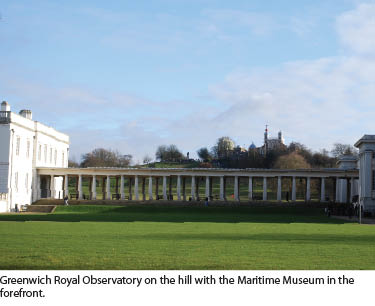
Greenwich Royal Observatory
After a full English breakfast prepared by our designated chef, Stephen Letchford, we all took a train into London where we then rode the subway, or, as Londoners refer to it, the Tube, and headed for our tour of the Greenwich Royal Observatory, which is ground zero for any self-respecting surveyor.
The Royal Observatory is the home of Greenwich Mean Time and the Prime Meridian of the world. It is also home to London’s only planetarium, the Harrison timekeepers, and the UK’s largest refracting telescope. It is situated on a hill in Greenwich, overlooking the Thames River.
 The Royal Observatory was founded by order of King Charles II in 1675 to study astronomy and to solve the problem of finding longitude at sea. The idea was to compile measured positions of the stars relative to the moon in order for sailors at sea to calculate the time at Greenwich, because if we know the local times at two points on Earth at some reference point, we can use the difference between them to calculate how far apart those places are in longitude, east or west. In the end, 18th century clock maker John Harrison constructed a marine chronometer (H4) that solved the longitude problem. His famous clocks, H1, H2, H3, and H4, are on display in the museum.
The first Astronomer Royal, John Flamsteed, lived in the four rooms of the ground floor and worked in the Octagon room above until his death in 1719. His successor in the office was Edmund Halley, famous for the comet that bears his name.
The time ball on the roof was first erected in 1833, providing the first public time signal. At 12:55 p.m. every day the ball rises up the pole. The ball then drops at exactly 1:00. Because the ball can be clearly seen from the river, ships have used the signal to check their time.
 After touring the Royal Observatory and having our pictures taken straddling the Prime Meridian line with one foot on East Longitude and the other on West Longitude, it was time to visit the Greenwich Tavern for a pint of bitter with fish and chips. Weirdly, in England one gets a portion of green peas with every meal (no matter what you order).
Later that evening after returning to Castlethorpe, we found another wonderful pub named the Barley Mow on the edge of a canal, specializing in homemade fish pie and plenty of ale. You might notice that we spent considerable time in pubs, purely for informational purposes.
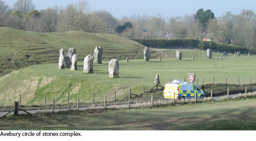
Avebury Circle of Stones and George Washington’s Ancestral Home
The next morning we decided to drive out to the Avebury circle of stones, which is 25 miles north of Stonehenge and is argued to be the most impressive of all remaining prehistoric earthworks (henges) in England. This place was absolutely fantastic with giant stones laid out in a tremendous circle surrounding the village of Avebury.
 After walking among the stones and taking a plethora of pictures, we found (you guessed it) the Red Lion pub in the center of the village, just in time for lunch and a pint.
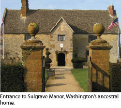
Next was a tour of Sulgrave Manor, built in 1539, the ancestral home of George Washington. His family story started with Lawrence Washington who married Elizabeth Gough, a rich widow, whose money helped him prosper as a wool merchant. Due to the dissolution of the monasteries, he was able to buy the manor of Sulgrave for around 325 pounds. Lawrence was a feisty old coot, born in 1500, and lived to the ripe old age of 84!
In 1656, John Washington, great-great-grandson of Lawrence Washington, emigrated to Virginia. Because the civil war was raging in England and the Washington family was Royalist, it is likely he went to Virginia to escape persecution. There, in 1732, his great-grandson, George Washington, was born.
Not much of the original building exists today, just one segment, two floors. The grounds and the house are now a museum run by both the English and the Society of the Colonial Dames of America. The Great Hall has a beamed ceiling and a stone floor. The fireplace is large enough to have a seat built inside, where a small boy could turn the spit for roasting and cooking (a dangerous job).
A painting of George Washington (by Gilbert Stuart) sits over the mantel, the most valued object in the house. The gardens are beautiful, and an American flag flies on the flagpole near the house. After the tour we were served tea and cake by our host, Cymon Snow. The English seem to always have their tea ready for all occasions.
British Antarctic Survey
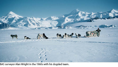 The next morning we drove to Cambridge for a private tour of the British Antarctic Survey building, hosted by our friend Alan Wright. The British Antarctic Survey (BAS) is one of the world’s leading environmental research centers and is responsible for the UK’s national scientific activities in Antarctica. The BAS has around 420 staff, with around 40 spending the austral winter in the Antarctic.
The original building, constructed in 1975, has been extended twice since then. It now provides offices, laboratories, and workshops to support all the scientific and logistic activities in the Antarctic. Our friend Alan was one of the surveyors who explored and surveyed the British-owned portion of Antarctica back in the 1960s and was instrumental in setting up our tour of the mapping department, directed by Adrian Fox. Alan related how his six-man survey crew with their dogsled team would load their equipment on the sleds and head out to a designated area to set up camp and spend several days surveying the area, all the while dealing with extreme cold.
On the top floor, Adrian showed us the fascinating collection of various maps produced from activities and scientific research in Antarctica. They now theorize that Antarctica is an archipelago surrounded by water, whereas the Arctic is water surrounded by land. This tour was certainly one of the high points of the trip.
Scott Polar Museum
Alan next led us to the Scott Polar Museum next to Cambridge University. The museum and research institute was founded in 1920 as the national memorial to Captain Robert Falcon Scott and his companions, who died on their return journey from the South Pole in 1912. It investigates issues relevant to the Arctic and Antarctic in the environmental sciences, social sciences, and humanities as well as has exhibits on display related to Scott’s expeditions.
On January 17, 1912 Scott’s team reached the pole, only to find that a Norwegian party led by Roald Amundsen had beaten them there. Tragically, Scott and his companions died of starvation and exposure in their tent on March 29. They were only 20 kilometers from their pre-arranged supply depot.
Royal Institute of Chartered Surveyors
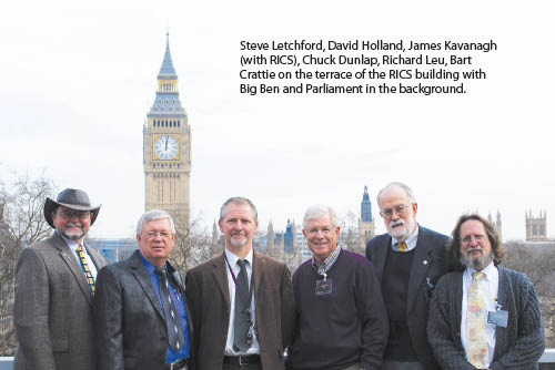
After another filling English breakfast, we once again headed for the train station for our 11:00 a.m. meeting with my friend, James Kavanaugh, who is the director of the Land Survey Group of the Royal Institute of Chartered Surveyors (RICS). The RICS is a representative UK professional organization established in 1868 by Royal Charter, which regulates property professionals and surveyors in the UK and other sovereign nations.
The very impressive headquarters building is on the corner of Great George Street and Parliament Square in the heart of London. The English Parliament, Big Ben, and Westminster Abbey are within walking distance.
The RICS is represented or has affiliates in more than 146 countries and has a worldwide membership of 163,000. Their mission is to be the publicly recognized authority on all aspects of surveying and the ownership, occupation, development, and management of property in the UK and to expand its recognition worldwide. The RICS also has close links with national surveying institutions and is a member of the International Federation of Surveyors (FIG). Our own NSPS and the RICS work closely together, and our delegation was particularly interested in meeting with the RICS while we were in England.
We discussed with James differences and commonalities between boundary surveying in England compared to boundary surveying in the United States. The essential difference is the concept of “general boundaries” and the existence in the UK of a National Mapping Agency (The Ordnance Survey) that has a highly accurate national large scale mapping data set (1:1250 urban, 1:2500 rural, 1:10,000 mountains and moorland), which underpins real property registration (and therefore the state guarantee of title), comparable to a modified Torrens System.
The Land Registration Act of 2002 was passed to simplify and modernize the law of land registration. It stipulates that registration of an estate in land is compulsory when one of the following events occurs: a freehold estate is transferred, a legal lease for more than seven years is granted or transferred, or a grant of a first mortgage is initiated. Failure to register when required means that the purchaser or transferee gains only an equitable title to the land, and the seller or transferor remains as the registered proprietor.
Also, the UK has been settled without invasion (with the exception of the civil war in the 17th century) since 1066, and most rural properties in the UK have been bounded by hedges that define the boundaries. There is no land taxation; only the property is taxed. Therefore, the “cadastre” in Europe means a Napoleonic “fiscal cadastre.” So, a chartered land surveyor effectively becomes a dispute moderator with the recourse to a determined boundary being a form of dispute resolution. Thus, in the UK, a boundary is a matter of legal definition rather than physical.
Whereas the U.S. does not have the same level of accuracy in its national mapping (USGS is 1:24000) and was rapidly settled in the 18th & 19th centuries (a relatively short time period), a measured cadastre was and still is required, for the most part. Also, the concept of an individual right to own property is enshrined in our constitution.
Another difference is that the specialist qualifications of RICS members include all property- and construction-related activities. For example, activities in which members may be specialists include: licensed property, land surveying, property transactions, real estate appraisal, property valuation surveying, mineral surveying, construction cost management, project management, property development and regeneration, and the list goes on.
Rolls-Royce
Thursday proved to be our longest day on the road because we were scheduled to tour the Rolls-Royce plant in Chichester, England, which was approximately 135 miles from our home base in Castlethorpe. As everyone knows, in England one drives on the left side of the road, which can be dicey at times if one is not experienced. Also, roundabouts are used predominately instead of red lights at intersections. So, driving the back roads of England can be quite an experience and requires extra caution and focus for us “Colonials.” Fortunately our “Bloke,” Stephen Letchford, was born and raised in England and did most of the driving. Nonetheless, we arrived at the Goodwood Plant on schedule and our delegation received the VIP tour. After BMW bought the rights to the Rolls-Royce brand from Vickers in 2003, it required a new manufacturing plant in which to build the new cars. This plant was designed to fit its environment and has a “living roof” made of sedum plants which help the property blend in with the countryside. Rolls-Royce produces the Wraith, the Phantom, and the Ghost which are all hand-built at the home of Rolls-Royce at Goodwood. From seamtresses to surface finish technicians and French polishers, it takes 60 pairs of hands to design, craft and construct a Rolls-Royce before it’s ready for its owner. Each Ghost goes through 16 stations with a build time of an hour each, while the Phantom is fitted in 11 stations at 2 hours each. So essentially, every vehicle in the plant has been sold (bespoke) with delegated directives from the buyer. For example, one female buyer had an Irish Setter and she wanted both the exterior and interior colors of her Phantom to match her dog’s hair color. So, they flew her and her dog to Goodwood in order to mix the paint to match the dog’s hair color. Our tour guide introduced us to the history of Rolls–Royce and we were fitted with a white lab coat and white gloves in preparedness for our tour. We were then taken to the production floor and were guided to each phase of production from the marriage between the body shell and the powertrain then over to the wood shop, the paint shop, the embroidery shop all way to the finished product. No wonder a Phantom costs in the neighborhood of one-half million dollars. The “Spirit of Ecstasy” hood ornament that adorns each of these cars represents the apotheosis of automotive luxury.
A Local and Tourists
After finishing a tour of the Rolls-Royce factory, we motored over to Petersfield for a short visit with our friend Jim Smith. Jim is a well-known author who wrote the book Everest: The Man and the Mountain that traces the life and profession of George Everest, particularly his life dedicated to surveying in India during the first half of the 19th century.
Jim is currently writing a book on the Struve Geodetic Arc, a triangulation chain that was measured from 1816 to 1855 to determine the exact figure of the Earth, its size and shape. The Arc stretches over 2820 kilometers from Norway to the Ukraine and passes through 10 countries. He is also working closely with UNESCO and FIG to preserve this historical triangulation network within the project on an international level.
We ended our visit with day trips to London, where we toured the Churchill War Rooms, British museum, and British library, rode the Thames River water taxi to the Tower of London, ate lunch at Bill Wyman’s (Rolling Stones’ bassist) Sticky Fingers restaurant, and purchased souvenirs at the Sherlock Holmes museum (221b Baker Street), to name a few. All in all, this was a trip for the books. The history of the development of the surveying profession in America essentially began with the growth of the science of surveying in late Renaissance England, which makes a trip to England a high priority on any surveyor’s bucket list.
David L. Holland, LS is the county surveyor for Henrico County, Virginia and a licensed surveyor in the Commonwealth of Virginia. He is the Virginia NSPS director and governor and past-president of the Virginia Association of Surveyors.