Several years ago, the North Carolina Railroad Company (NCRR) began using geospatial technology to augment its rail corridor management program. An article in this magazine (July 2010, “History and Technology Merge Geospatially”) focused on the geospatial technology, outreach programs, and processes the railroad is implementing to manage a rail corridor that is more than 160 years old, 317 miles long, and 200 feet wide.
Many of NCRR’s practices can still be considered innovative and progressive for an organization of its type, but none more so than its monumentation project. This project, briefly mentioned near the end of the 2010 article, has since gotten underway. Despite providing numerous project updates to various groups across the state, NCRR continues to field significant interest in the project’s purpose, approach, progress, and lessons learned.
Purpose
 The NCRR is a private company whose sole shareholder is the State of North Carolina, and the 317-mile rail corridor NCRR actively manages is an irreplaceable asset. Properly managing the real estate and other aspects of the corridor requires a lot of planning, careful analysis, and coordination. The basis for much of this work comes from the simple question, “Where is the corridor located?” More specifically, the question is, “Where was the centerline of the corridor originally located?”
This question has many implications to NCRR’s business, but it can also affect others such as surveyors, title attorneys, realtors, engineers, utility companies, and even adjacent landowners and local governments. Due to the passage of time and presence of misinformation (or lack of correct information, depending on how it is viewed), the location of the NCRR rail corridor centerline is not always easily identified; therefore, the main purpose of the project is to accurately locate it.
The project will provide additional benefits, including three products to be created over the course of the project: 1) a survey-grade accurate original rail centerline with coordinate geometry, 2) a series of recorded surveys for sections of railroad centerline that no longer coincide with existing track and boundaries of miscellaneous properties outside of the 200’-wide rail corridor, and 3) geodetic monumentation on both sides of the NCRR rail corridor boundary (spaced roughly a half mile apart). These three products will provide a valuable resource in high-order geodetic control network densification (accessible without the need for a railroad right of entry) and a modernized survey record of historically acquired railroad properties along the NCRR.
Approach
 The NCRR monumentation project is unique and thus requires a thoughtful approach. Although boundary surveys, centerline surveys, and monumentation had been done on railroads before, NCRR was challenged to find case studies of a railroad project of significant length with a mixture of existing original centerline track, missing original centerline track, 160 years of track relocation projects, general maintenance, and heavy everyday railroad use. Given that NCRR is one of a kind in its organization and how it manages its corridor, similar scenarios were not available. It became clear that NCRR was setting out to do something different, progressive, and possibly unprecedented. Thus, NCRR determined that the monumentation project would need to be completed in three major stages: an existing track centerline survey, a historical track centerline survey, and geodetic monumentation.
Existing track centerline survey
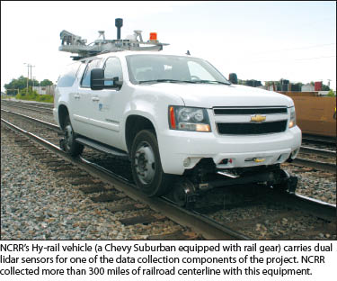
To be able to place geodetic monumentation on the NCRR corridor boundary, the rail centerline first must be located. Through the use of historic maps, NCRR is confident that the majority of the existing rail remains in the original centerline location (circa 1851). But no one can account for the amount of specific track that has moved due to railroad use, atmospheric conditions, maintenance, and other factors. Therefore, it was decided that normal track movement from heavy trains and hot summers would be discounted, and the present location of track that has never been purposefully relocated or re-engineered would meet the requirements as an accurate account of the NCRR corridor’s original centerline. 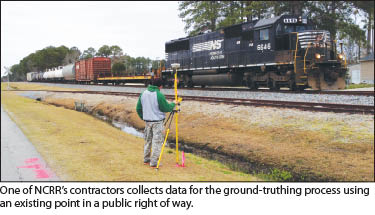 Collecting the existing track centerline data for 317 miles needed to be done efficiently and accurately, so NCRR employed lidar technology and collected the data using NCRR’s Hy-rail vehicle (a vehicle outfitted with rail gear) with dual 200 KHz lidar sensors and GPS receivers, an inertial measurement unit, a distance measurement unit, and camera equipment mounted to the roof. Proper ground truthing procedures were employed by the lidar contractor as well as an independent consultant to check known points against the lidar data.
When the data collection was finished, the top of rail features in the lidar point cloud were classified and extracted in order to extrapolate a rail centerline alignment that was later best-fit so central angles (deltas) of curves agreed with tangent bearings, thereby creating true points of curve and tangency. This alignment ultimately would not prove to be as uniform as what is presented in historic railroad maps, but it is an accurate reflection of where the tracks are presently located. (For a more in depth discussion of the implementation of lidar technology in this instance, see PSM’s November 2012 article, “Riding the Rails with Mobile Scanning.”)
This rather logistically challenging stage of the monumentation effort was the initial building block for the much larger project. Ultimately, the deliverables for this stage were horizontal locations of existing track centerline for all main, passing, and siding tracks along the NCRR corridor delivered as alignments complete with coordinate geometry. This product provided a basis for both the historical track centerline survey and geodetic monumentation stages of the project to follow.
Historical track centerline survey
 Unfortunately, surveying the location of existing track is not enough to fully identify the location of the entire corridor. Careful analysis of historic railroad maps (railroad valuation maps, or val maps) revealed that approximately 45 miles of original corridor centerline is no longer coincident with existing track locations. Over the years, engineering projects that straightened, realigned, or double-tracked the railroad have obliterated the original tracks marking the centerline of the corridor, and these sections are scattered across the NCRR. As advanced as lidar technology may be, it was of little use in these cases. Simply put, lidar cannot map what is no longer there.
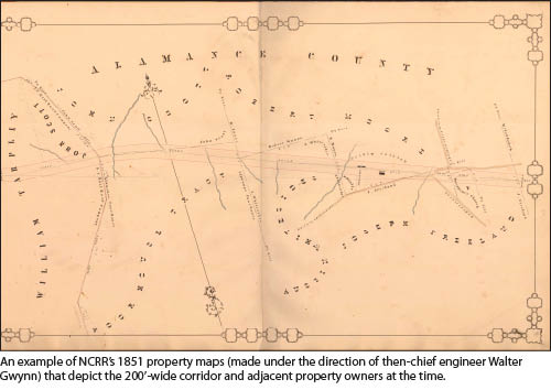
To survey any section of original corridor rail centerline that no longer exists, NCRR needed to contract for expertise in rebuilding a rail centerline alignment from historical records and field evidence. Essentially, this work has required examination of a hierarchy of evidence that supports the location of the missing original historical centerline: 1) railroad val maps, 2) courthouse records (deeds and plats) that were surveyed and recorded prior to engineering projects that revised the original track location or that make reference to and show dimensions to the original centerline, and 3) field evidence and artifacts. In addition to property corners and possession, many features shown on the historic railroad val maps such as culverts, bridge bents, and other hard structures are still in place today, providing valuable evidence of the original railroad alignment. 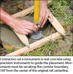 Collectively, the presence of these three resources often provided an extremely accurate representation of the corridor location. The historic valuation maps often include track geometry for a specific point in time early in the railroad’s existence as well as crucial adjacent owner details. Taken as a whole, valuation maps, historic deeds and maps, property evidence, and existing railroad artifacts from previous alignments all serve as a body of evidence supporting the retracement of the original corridor centerline.
The necessary courthouse research for this part of the project can be exhaustive and a matter of timing. Accurate documents showing the location of the original historical corridor centerline track prior to its removal due to track realignment projects were critical and required, and this is why timing is important. Every section of removed original historical track may be from a specific era of the railroad’s existence. Complicating the research was the fact that the bulk of records show only the current track location. Weeding these references out and focusing on those showing past alignments was a methodical, time-intensive process, requiring investigation into multiple eras during which the track realignments occurred.
Once obtained, this research was used to aid in the recovery and documentation of key property corners supporting the location of the original corridor centerline and which, in turn, served to further corroborate the entire body of evidence. Fortunately for NCRR, the courthouse records have provided a reliable source of evidence to further support the field evidence aspect of the research.
NCRR has been fortunate because many of the major changes in the railroad’s alignment have been easy to spot in the field. Remnants of the old track bed, stone box culverts, and even trestle bridges aid in locating the original centerline. In addition, the physical presence of property corners shown on historical courthouse records shed even more light on the alignment. Finding property corners referenced in historical documents, which contain curve data and other geometry, is considered invaluable for this type of work. Ideally, the field evidence and documentation research agree with the historic valuation maps. When this validation occurs, a solid case can be made for the location of the missing historical track centerline, and an alignment is produced that is ultimately merged with the lidar data of existing track.
This comprehensive evidence-gathering is ongoing, and the evidence will be well-documented in the form of detailed historic centerline survey plats that will be recorded in the respective counties. Each of these maps will make reference to historic railroad maps, pertinent deeds, and field evidence, giving a clear picture of an often-forgotten original railroad centerline. By making this data available, NCRR seeks to alleviate many future land ownership issues that result from lack of information near the corridor.
Geodetic monumentation
By accurately identifying the location of the original track centerline, NCRR then can embark on the third and final goal for this project: geodetic monumentation. NCRR has chosen to install permanent monumentation using NOAA NGS-58 guidelines for 2-cm accuracies (“bluebooked”) on either side of the corridor boundary, spaced approximately a half mile apart. Because NCRR did not perform a boundary survey of the entire corridor, the surveyed centerline geometry is used by the surveyors to define placement of the new monuments along the boundary. Each monument location is initially sited using GIS and aerial imagery, which is refined through field reconnaissance and computations by the surveyor. North Carolina is fortunate to have a reliable VRS-GPS network that is used, along with computed points and alignment information, for the initial staking of the proposed monument locations.
Normal height modernization or geodetic control densification projects simply consider suitable locations where the monuments are needed and will not likely be disturbed, but NCRR added an additional challenge by requiring locations to be on the corridor boundary. Therefore, when faced with an unsuitable location (heavily trafficked, poor GPS visibility, hard structure, utility conflicts, etc.), the search for a new location is further constrained by the requirement to stay on the corridor boundary, or 100’ from the original corridor centerline.
Add the specification for approximate half-mile spacing between monuments, and placement of monuments can be challenging. In fact, of the 1,268 potential monuments (4 per mile X 317 miles), only 850 were revealed to be feasible by inspection of aerial imagery. It is anticipated that far fewer monuments will be placed because field reconnaissance may rule out many of them.
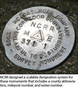
However, NCRR views this project as an ongoing effort, and the naming convention (designation) for the monuments was created so the system would be scalable and would allow for the placement of additional monuments should field conditions improve. Once placed, the monuments must be observed using static GPS procedures and properly reported in order to be published. NCRR and its contractors work closely with the North Carolina Geodetic Survey (NCGS) to ensure that all readings meet the required accuracies. Once approved, this data will be published by the National Geodetic Survey (NGS) and made available to the general public.
In addition to the monuments and accompanying published data sheets, NCRR will record control network maps for each phase of the monumentation project in its respective county. These maps will serve as an additional resource for real estate or engineering projects along the corridor and elsewhere and will help increase awareness of the unique NCRR corridor.
Progress
At the close of 2013, NCRR had completed the lidar survey of the existing track and is now placing the final touches on the historical centerline survey. Once complete, an alignment that combines the two surveys will be produced for the entire corridor. NCRR anticipates making this available to surveyors as a supplement to conventional surveys near the rail corridor. Such surveys require a railroad right of entry and possible on-track protection in the form of railroad-employed flagmen. This will help reduce cost to surveyors and eliminate the safety risks of accessing the corridor.
To date, monuments have been placed in five of the sixteen counties through which the NCRR runs. The monumentation missions were able to be accelerated in an east-to-west fashion because just over 100 miles of corridor centerline is considered to be undisturbed, meaning it has never been relocated or re-engineered and does not require a historical centerline survey. More than 200 monuments have been installed in those five counties, submitted to NGS, and currently await publication. Another five counties, currently in progress, account for approximately 300 additional monuments covering a project-to-date total of 208 miles and over 500 monuments.
Lessons Learned
The project has endured three years of logistical challenges and hard work by contractors and government agencies and will continue for another year, at least. There have been many lessons learned so far, but none have come at any significant detriment to the project. The main two lessons have been in the areas of geodetic monumentation placement and community engagement.
Over the course of the project, there has been and continues to be a host of accuracy checks and double checks. Initially, NCRR conducted a pilot project for the monumentation aspect that consisted of ten points in a somewhat urbanized area that was representative of the entire project. This pilot project paid dividends because NCRR learned that even with instituting strict accuracy requirements, a small ”forgiveness” tolerance still should be built in at certain points during the monumentation to help ease some inevitable location constraints while still maintaining the required accuracy.
For example, a small level of flexibility in the willingness to accept a limit of 10% of reported vectors that exceed 10 kilometers will be able to exceed the 2-cm standard but would still have to meet the 5-cm standard. This allows monumentation contractors some leeway in observing a monument but comes with the caveat that reconnaissance procedures should be much stricter to prevent placement of a monument that cannot be adequately observed, or ”achieved.” This flexibility helps control cost for NCRR and prevents wasted effort for the contractor while still maintaining the necessary accuracy.
Another lesson NCRR will take away from the corridor monumentation project is community engagement, specifically, the surveying community at large. While NCRR is conducting this project to better document the location of the railroad, it will be a useful resource to surveyors across the state. The same surveyors benefiting from this project have been instrumental in guiding its purpose as well as its procedures. This is no accident, because NCRR has taken great strides to promote the monumentation project at local surveyor society chapter meetings, conferences, and one-on-one meetings, which has led to valuable feedback for NCRR to ensure the integrity of this project.
As an extension of the community engagement, NCRR has worked to educate local government about the location of the corridor. The NCRR corridor passes through 16 counties, and each county has an online GIS that many surveyors often turn to for their initial research. NCRR is working with every county to ensure that the tax parcel layer accurately reflects the NCRR corridor, including ownership details, so surveyors have a better understanding at the onset of their projects.
NCRR prides itself on being a progressive and accessible organization. In fact, the newly adopted NCRR mission statement is, “To develop the unique North Carolina Railroad assets for the good of the people of N.C.,” and one way this mission will be accomplished is by investing in the railroad. The monumentation project is just such an investment that will continue to serve communities within the state and provide a definitive and lasting record of the North Carolina Railroad’s location.