Collaboration among Pennsylvania surveyors exemplifies the spirit of the National Height Modernization campaign.
The Pennsylvania Society of Land Surveyors (PSLS) recently launched a new initiative known as PSLS Reaching New Heights (PRNH). This initiative expands upon the National Geodetic Survey’s (NGS) GPS on Bench Marks Campaign (see sidebar at far right) and will be used to prepare Pennsylvania for the implementation of GRAV-D and the new vertical datum in 2022.
In order to be ready for National Surveyors Week sponsored by NSPS (March 16-22), we implemented PRNH in a very short period of time. We were able to do this successfully because of the technology-forward attitude we’ve embraced over the past two years.
As National Surveyors Week wraps up, PRNH’s and PSLS’ public relations efforts appear to have succeeded well beyond our initial hopes. We have plans to transition PRNH to a permanent PSLS effort and are working on ways to improve our National Surveyors Week activities next year.
Early Discussions
 At the annual PSLS conference held in mid-January 2014, several side conversations regarding National Surveyors Week and GPS Day occurred, and they continued after the conference through email and phone calls. The consensus was clear that past National Surveyors Week activities lacked focus and did not generate the media attention PSLS desired. Furthermore, these conversations were all pointing to participating in the NGS GPS on Bench Marks Campaign, and doing it in a big way in order to provide sufficient data to greatly improve the next hybrid geoid model in Pennsylvania and to warrant media attention.
At this point we had only six weeks to refine our plan and implement it.
Planning
The first meeting of the PRNH organizers was held January 31. The meeting was attended by Dave Conner, NGS state advisor to Ohio; Adam Crews, PSLS president; Mike Kreiger, PSLS president-elect; Frank Lenik, NSPS area director; Bruce Lewis, PSLS state director; and me, Brian Naberezny, PSLS geospatial committee chair and state director. It was at this meeting that PRNH took its current form.
PSLS would research areas of GEOID12A in Pennsylvania with poor accuracy and identify bench marks that would best resolve these deficiencies. Volunteers would be asked to occupy these marks for four and a half hours using dual-frequency GPS receivers. This data would then be submitted to the NGS Online Positioning User Service (OPUS) and published as shared solutions.
In order to spread the word and generate as many volunteers as possible, regional coordinators throughout the state would be identified and would serve as local contacts. Finally, we would contact media outlets throughout the state, seek volunteers interested in meeting with the media, and identify photo opportunities.
Duties were split among the participants. Adam Crews was responsible for recruiting regional coordinators and preparing handbooks detailing the responsibilities of coordinators and volunteers. Mike Kreiger was responsible for developing public relations materials and coordinating the outreach. I took on identifying the areas of concern, recommending bench marks, and developing an interactive map. Frank Lenik and Bruce Lewis were the first regional coordinators taking responsibility for the area covered by four PSLS chapters. Weekly meetings using GoToMeeting were held, which allowed our geographically dispersed group to collaborate from our offices, homes, and even in the field at a mutually convenient day and time without having to travel to meet face-to-face.
Identifying Bench Marks
 We relied on GIS extensively for identifying areas where the geoid accuracy was poor and for finding bench marks best suited to reduce or eliminate the areas of poor accuracy. Geoid heights from GEOID99, GEOID03, GEOID09, and GEOID12A models were compiled on a regularly spaced grid across Pennsylvania. We then computed the differences between each geoid model, and raster surfaces were created to represent these differences.
We also contrasted this with the GEOID12A accuracy estimate map published by NGS. When we imported the map into the GIS, we were reassured to see that many of the areas identified in the previous exercise were also areas of concern on this map. Locations of bench marks used in previous geoid models and their impact were also examined.
The NGS map and the results of the geoid model differences were combined to create a polygon layer that would serve as the PSLS geoid priority areas. It was not a surprise that many of the areas with poor geoid accuracy are rural areas in Pennsylvania that are largely undeveloped. Over the past several years, the pattern of development in the state has dramatically changed due to changes in the economy and the development of Marcellus Shale gas, and as a result accurate elevations are now needed in these undeveloped areas.
With the areas of poor geoid accuracy ascertained, we needed to identify bench marks to best reduce or eliminate them. Bench marks from the NGS database for the entire state were added to the GIS and symbolized according to their order and stability. Our goal was to identify bench marks that minimized gaps and overlaps in coverage with a preference for higher order and higher stability bench marks. While the criteria seem simple enough, it is much more difficult when put into practice, especially on a state-wide scale.
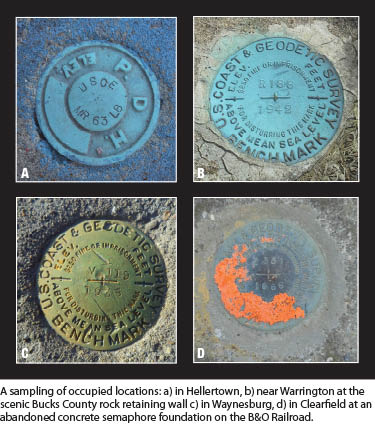
 To assess the existence and GPS suitability of bench marks, we used NGS datasheets, the bench mark hunting section of the geocaching.com website, and imagery provided by Google and Bing. We relied on documented recoveries, but reports of marks not found were relied upon only when they were reported by reliable sources or included sufficient documentation. Similarly, we relied on the GPS suitability reported on NGS datasheets only when reported by reliable sources or when ascertained from photographs or imagery.
In several areas of the state we were fortunate to have reliable recovery information provided by the Pennsylvania Department of Transportation. In a majority of the areas of concern, bench marks exist only in the railroad ROW and the highway ROW, and that presents many well-known challenges related to permanency, accessibility, safety, and GPS suitability.
Coordinating the Effort
We developed a webpage—www.psls.org/ReachingNewHeights—to serve as a single location where people could find information related to this effort. The webpage provides a description of PRNH and its benefits, the requirements to participate, and frequently asked questions. We also developed two handbooks and posted them to the webpage; one details the responsibilities of regional coordinators and the other the responsibilities of observers. For those interested in contacting and meeting with the media, a public relations guide was created as well as template press releases.
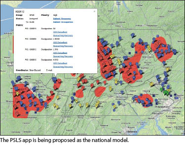
The PRNH webpage also contains an interactive map, developed using the Google Maps API, that displays the PSLS geoid priority areas, the territories for each regional coordinator, and the point groups PSLS wants occupied. All participant interaction is performed through the map.
A participant can use the map to pan and zoom and view imagery. When they find a point or point group they are interested in, they click on the point; a dialog is then displayed that contains the point group identifier, a listing of all the points in the group, links to the NGS datasheet, and the geocaching.com recovery for each point in the group, as well as contact information for the regional coordinator. These resources allow the volunteer to assess the points in the point group prior to volunteering.
The most important part of the dialog is a link to volunteer for the point group. Clicking on this link takes the participant to a form where they enter their contact information so we can track who volunteered for each point group. Registering participants for point groups was the mechanism we used to prevent duplication of effort. Once a point group is volunteered for, the symbol on the map changes to let others know the point group is spoken for, and the participant’s name or company name is displayed.
By volunteering for a point group, the participant has agreed to recover the points in the point group and identify which one is most suitable for GPS occupation. Recovery information is reported by clicking on the point on the interactive map. The dialog will display a link to a recovery form, which is pre-populated with the point group ID and the bench mark PID. The participant simply needs to enter his or her email address and select if the point was recovered, recovered but not suitable for GPS occupation, or not found.
Several photographs are also uploaded at this time to serve as a record of the mark recovered and any obstructions that may interfere with GPS occupation. Once a recovery is reported, the symbol on the map changes to reflect its status.
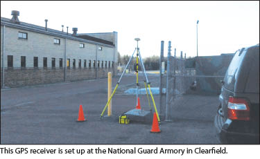
Once the most suitable point for GPS occupation in the point group is recovered and identified, participants occupy the point during National Surveyors Week for four and a half hours with a dual-frequency GPS receiver. Participants familiar with OPUS are required to submit the OPUS report, but those unfamiliar with OPUS can supply the raw data file, and PSLS submits it to OPUS.
PSLS is working with students from the Penn State surveying program who will use the recovery and occupation information to perform basic QA/QC on the OPUS results to help ensure quality results suitable for sharing. We are asking all volunteers to include “PSLS Reaching New Heights 2014” in their shared solution description.
Encouraging Participation
Due to the short time frame, we focused efforts to encourage participation solely on our members. PSLS and the PRNH organizers used a top-down approach by sending email blasts to all of its members, directing them to the webpage and announcing a webinar on the topic. This one-hour webinar was offered to members for free on February 19, discussing vertical datums, GRAV-D, and PRNH.
We used several other tactics as well. A bottom-up approach was employed through our regional coordinators. Their role was vital as they presented at chapter meetings and used their local contacts and connections to encourage participation and media attention. In order to create a spirit of competition among participants, PSLS announced that individuals and companies occupying the most points would be recognized. Also, PSLS offered free sustaining firm memberships for the remainder of 2014 to firms occupying five or more points.
Results
At the time of writing, National Surveyors Week has just come to an end, and PRNH has resulted in:
- 85 point groups volunteered,
- 118 point recoveries reported,
- 42 point occupations reported, and
- 17 shared solutions reported.
We are aware of numerous other point recoveries and occupations that were not reported through the interactive map, and we are expecting more occupations and shared solutions to be reported over the course of the next week or two. Furthermore, we have had an above-average winter in Pennsylvania in terms of snow, ice, and cold temperatures, and due to the remote location of some of these bench marks we anticipate it will be the end of April when some of them are accessible and occupied.
Additionally, we are pleased with the results of our public relations campaign: three newspaper articles accompanied by photographs of surveyors in action, including one front- page photograph.
Future Plans
Now we will be devoting our time to QA/QC and finalizing the data that has been submitted. A few occupations occurred on questionable marks and have been rejected by OPUS; these occupations will be assessed to see if we can change the mask angle or remove data from particular satellites, and we will resubmit them to OPUS in an attempt to render the occupation usable.
Plans to update the NGS datasheets with recovery information are also in place, and we are in the process of determining how we will acknowledge the approximately 75 people and numerous organizations who volunteered their time and made this effort a success.
Over the next few months we plan to implement improvements to address shortcomings as we transition this to a permanent PSLS effort. A decent number of the recommended marks could not be recovered or were unsuitable for GPS occupation. Volunteers found alternatives that were not included on our map, requiring reports to be submitted via email instead of through the interactive map. We plan on implementing a method to better allow for local knowledge in the bench mark selection process, and we hope to coordinate with Pennsylvania DOT as several mutually beneficial opportunities exist.
PSLS is planning on highlighting this activity again during National Surveyors Week 2015. We will further refine the roles of the regional coordinators to provide them with better instruction and expectations. We are also going to strive for more media exposure, especially in the larger markets of the state. We will examine avenues to share lessons learned, and we’ll share our implementation with other states and/or NSPS so our success can be replicated across the nation.
We have begun discussing how we will expand PRNH from improving the hybrid geoid model to preparing for GRAV-D by identifying where monumentation will be required and strategically performing repeat observations on bench marks in the 2018-2022 time frames. We are headed for a gravity-based datum, which will bring positive changes to our surveying profession, not the least of which is encouraging us to have more a direct hand in building our future.
First sidebar
The NGS “GPS on Bench Marks” Campaign
The National Geodetic Survey (NGS) has long recognized that the Holy Grail of physical geodesy for the vertical component of the National Spatial Reference System (NSRS) would be a purely gravity-based datum. This is because it would be, in many ways, far superior to any legacy systems or resources, but also in practical considerations because of costs and resources. Even the most current realizations of datum are based on modeled updates of physical marks that may not have been observed directly by the NGS for decades. While the gravity elements have seen modernization by the inclusion of much more data than ever before by adding airborne and satellite gravity data, updated data are needed directly on passive marks.
The NGS GPS on Bench Marks Campaign (ngs.noaa.gov/heightmod/GPSonBM.shtml) encourages surveyors to perform, following best practices and guidelines, fresh GPS observations on first- and second-order bench marks and to submit these observation to OPUS-DB for inclusion in the upgrades to the geoid and hybrid geoid models that will be the realization of the new datum.
The NGS plans to launch this gravity-based datum in 2022-2025, but there is, and will continue to be, a need for new observations to help develop and maintain the NSRS. What better way for surveyors to help chart their future? Consider that the more you contribute, the better the resources for your own state and locality.
Second sidebar
A National Model?
During National Surveyors Week 2014, as well as over recent years, surveyors and state societies across the country exhibited levels of cooperation and selfless dedication not seen in our profession for quite some time. What the PSLS added was not only a particularly high level of coordination in their own “Reaching New Heights” initiative; they also employed elements of modern spatial IT with their interactive map and crowd-sourcing app.
If something works well, why not emulate it in other states, or even on a national level? The map and app are surprisingly elegant in their simplicity and ease of use. For little or no cost, this model could be implemented for every state long before National Surveyors Week 2015.
The newly reborn NSPS has had a major role in promoting National Surveyor’s Week and the bench mark campaign. While the “all-in” membership initiative via state societies has gained momentum, so has the call for tangible missions for the society by those who have already joined and those considering.
In addition to current activities, what better mission could a national society have than fostering the development and maintenance of such a critical element of our nation’s infrastructure? Just think of the outreach opportunities.