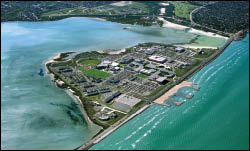
The innovative Conrad Blucher Institute for Surveying and Science is educating the next wave of surveying and geomatics professionals at Texas A&M – Corpus Christi.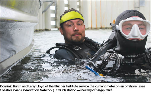 If you were to endow a new facility for a surveying school and university campus, where would you put the building? To a surveyor, the choice is obvious: on the highest point you could find, especially if it were on an island campus like that of Texas A&M University – Corpus Christi (TAMUCC). That’s exactly what celebrated Texas surveyor Conrad Blucher did when he created the Conrad Blucher Institute for Surveying and Science (CBI), cementing the role of surveying and mapping as an important and unique part of TAMUCC.
The institute is the cornerstone of the surveying, GIS, and geomatics sciences programs of the university. In addition, the CBI conducts pure and applied research, supporting many of the industries critical to the Gulf region, and hosts the Texas Spatial Reference Center, serving in a leadership role in the state’s Height Modernization Program.
The Legacy
 The Blucher family line carries a long surveying legacy: Conrad’s grandfather, Baron Felix Von Blucher, first arrived in Corpus Christi in 1848 serving as an interpreter and engineer for Prince Solms Von Braunfels, who spearheaded the establishment of German immigrant settlements in Texas. The first in a long line of Corpus Christi surveyors, Felix became the Nueces County surveyor and district engineer and had a child named Charles who became the Nueces County surveyor from 1882 to 1934. Charles’ son Conrad occupied the same office as his father, starting in 1934 and serving as the county surveyor until 1954; this retirement ended more than 100 years of the Blucher family surveying in south Texas.
Though he was done surveying for the county, Conrad remained a prominent force in surveying, winning awards and holding professional association officer positions. He and Zula Blucher transferred their estate to Corpus Christi State University (later to become Texas A&M University – Corpus Christi). Posthumously, the Conrad Blucher Institute for Surveying and Science was dedicated in their honor on May 17, 1987. This institute helped pave the way for the university’s GIS/geomatics bachelor of science degree, with the first graduating class in 1998. This bachelor’s degree has since evolved, and the university now offers a master’s degree in Geospatial Surveying Engineering.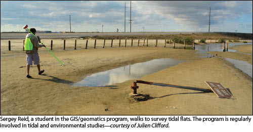 Hidden in a small building on the awkward side of the island on the south side of Corpus Christi Bay, the Conrad Blucher Institute is rapidly changing the landscape of surveying and GIS in Texas as well as around the nation. Though the university is growing in size, the geomatics program usually has around 80 students enrolled.
The program is small; its reputation, however, is large and growing. It is known across the nation as a place from which to draw students experienced in not only solid surveying fundamentals, but also the increasingly non-traditional skills expected of modern surveyors. Students are exposed to everything from hydrographic and tidal research, UAS, data management, development of apps, remote sensing, and more. These advanced skills are in high demand; it is not uncommon for top-tier companies to troll the TAMUCC booth at conferences looking for recruits.
TAMUCC GIS Program
 “I first came here in 1990, and part of my job was to set up a new degree in surveying and mapping,” says Dr. Gary Jeffress, the director of the Conrad Blucher Institute, as he leans forward in his chair. Jeffress, an Australian native, cut his teeth surveying in his home country. He then attended the University of Maine, where he received a Ph.D. in surveying engineering. At the CBI he aided in creating the unique, ABET-accredited undergraduate degree in GIS/geomatics that the school is now renowned for; he was joined by a panel of other distinguished experts in surveying and mapping. “We were the first university to incorporate all the different aspects of surveying and mapping into one degree; the program was introduced in 1995, and our first full graduating class walked the stage in 1999.”
He calmly searches among the documents on his desk, papers riddled with statistics about the surveying profession and its future, and finds what he is looking for: a comprehensive study, done in Australia about the future of surveying and its need for new professionals. He flips through the document, stopping at a page that shows a graph of the demand for surveyors versus supply. The line representing supply gradually slopes downwards, while the demand shoots erratically up. “This is the problem; it’s no longer a surveying issue, it’s a national issue. With few surveyors, it will get harder and harder for the housing market to move forward. That’s what we’re trying to address with this program.”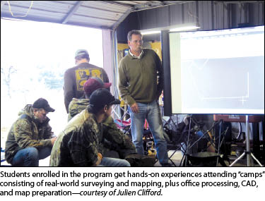 Most of the students come to the degree because of exposure to GIS in high school; this leads them to the GIS major at TAMUCC. These students, having no experience with surveying, quickly find themselves interested in surveying and geomatics. “Interested in surveying,” however, is an understatement; Jeffress cites a mind boggling statistic—of all the students who graduate from the “GIS” degree, about 75% of them have become gainfully employed in land-survey-related fields. This remarkable phenomenon is due in part to the increasingly holistic and inclusive nature of the profession—broadening field, broadening markets, broadening appeal. Students are enticed by the unique combination of desk and outside work; such a mix helps provide diversity where other professions may lapse into monotony.
Refuting the conventional wisdom that holds that surveying is somehow a shrinking or stagnant profession, Jeffress states, “Surveyors are in great demand, and it’s our job to introduce new students to this amazing profession.”
Students of Surveying
The undergraduate degree provides many opportunities for learning the fundamentals of surveying; part of the required classes for a student in the degree, regardless of emphasis, are the basic surveying classes. These are taught by experts in the field from every walk of life, and they stress the fundamentals of surveying repeatedly. All of the students are required to take Plane Measurement I, a class that teaches the basic methods with which a survey is done; the students get hands on-time with modern surveying equipment and have to perform calculations and make determinations about boundaries. Also required are classes that teach the basics of boundary law and the history of the state of Texas.
Students who choose an emphasis in geomatics are required to take two field camp classes; these are week-long courses that simulate a real surveying project. Proceeding as if the class were a surveying company, the students start a surveying job from beginning to end, from the field work to the final deliverable. In addition to these classes, there are rigorous courses in subjects such as remote sensing and surveying computations, adjustments, and geodesy.
Students who also work at this institute have the unique opportunity to work one-on-one with the faculty, something that is encouraged by the open atmosphere at the CBI. Faculty members frequently allow students to collaborate, and the entrepreneurial instincts of young students have often resulted in new projects and ideas that have since become cornerstones of CBI. For this reason many of the employees are also graduates of TAMUCC.
Though the GIS program is prestigious nationally and internationally, it is not well known around the campus; all too often, other students or townsfolk respond with “What is that?” Despite being somewhat invisible in plain sight, the GIS program is thriving thanks to an intense recruitment campaign where students volunteer, present at campus events, and promote the GIS/geomatics program. Part of the draw of the program is outstanding placement prospects. Once students graduate, they find themselves in an interesting yet enviable dilemma—which job does one take, when surveyors are in such great demand?
Why the great demand? Land surveyors are becoming an increasingly rare find; Texas in particular has only 22 registered professional land surveyors under the age of 30. This leads to an interesting job market that bucks the current trends seen in other aspects of college educations (there are too many jobs and not enough people). Not only are the jobs plentiful, but this phenomenon repeats itself with internships; students often find themselves fielding offers from multiple companies. These students don’t have to wait until graduation to work in a surveying-related field, however; they have many opportunities to experience surveying and mapping at their own school through work study programs and involvement in R&D projects.
Research to Operations
“The CBI conducts research that helps geospatial experts across the country,” Dr. Philippe Tissot says enthusiastically; he is the associate director of the Conrad Blucher Institute and a key force behind both the research and education aspects of the CBI. Tissot, a native of Switzerland, often assures the students that he has been in Texas since the late 1980s, making him just as much if not more Texan than the research assistants born since then. He came to the institute with a Ph.D. in nuclear engineering from Texas A&M University – College Station with a plan to model tides using a neural net model, a type of artificial intelligence. This prediction model has earned him many accolades, and the method remains one of the most computationally efficient ways to predict water levels. “This institute, though small, is helping push the boundaries of surveying and geospatial science,” adds Tissot.
Because of the concentration of practiced and practicing surveyors in its employ as well as a proven record in land surveying, the CBI has been able to attract work from all around the nation. In 2005, NOAA awarded the CBI the task of creating the Texas Spatial Reference Center and the respective Height Modernization Program, re-establishing and updating elevations throughout Texas, making this information available to surveyors, geodesists, and other researchers and scientists.
The CBI’s largest project is the ongoing maintenance and improvement of the Texas Coastal Ocean Observation Network (TCOON). This is a network of tide gauges that populate the Texas coast, diligently reading various parameters related to the ocean and reporting them to the school every six minutes. Water level, currents, temperature, and other parameters are recorded and logged in a database where certain stations have data dating back more than 20 years. The densest sensor array of its kind in the world, the system consists of 17 stations across the coast of Texas. Not only does CBI install and maintain these stations, but the data is all stored and processed on the island as well.
The data has been used for improving weather forecasts, and the information gained over the years has led to developments in bringing this data to the users. Complex data, when analyzed by scientists, tends to stay complex; this is something that CBI is trying to solve. Currently, several projects at the institute focus on bringing complex environmental data to users who would otherwise not be familiar with scientific datasets.
One such project is the “Transit Time!” mobile phone application, developed by CBI to help shipping pilots and other users with navigating ship channel status and specifics. Complex data, in the form of hydrodynamic model predictions, exists on the internet and currently is consumed only by scientists and those well-versed in awkward file formats and data structures. This application downloads the latest hydrodynamic models and reduces them into a more understandable format that can be used to tell ship pilots where they will be along the channel in the future, taking into account their speed and location and the conditions when they get there.
This oasis of knowledge hidden in a Texas beach town has grown into an internationally recognized hub of innovation and education. The students who pass through the program gain valuable knowledge in the field of surveying as well as the opportunity to work with faculty members on research projects and field operations. This collaboration of students and staff helps to foster an environment of unique opportunity and provides most of the students with job offers before they graduate.
The faculty is setting an example of how to remedy the growing deficit of surveyors present around the world. This is not an easy task. It requires a sort of “marketing push,” an increase of the overall awareness of surveying as a profession.
SIDEBAR
Texas A&M University – Corpus Christi
Founded in 1947 as the University of Corpus Christi on the former naval radar training facility occupying Ward Island, the university has been known as Texas A&I University at Corpus Christi, Corpus Christi State University, and finally Texas A&M University-Corpus Christi. It currently has an enrollment of more than 10,000 students, offers more than 60 of the most-popular degree programs in the state, and hosts the only ABET-accredited combined GIS/geomatics-focused bachelor of science degree of Geographic Information Science in the nation. The university now also provides an online master’s degree in geospatial surveying engineering and is applying for a new Ph.D. in geospatial computing sciences. The degrees are supported by the largest GIS and geospatial surveying engineering endowment in the country.
SIDEBAR
Mobile Apps by the Blucher Institute
The following applications, developed by the CBI, are examples of how to convey complex scientific data via an easily understandable interface. They are constantly updated, and more applications are on the way. To access them, enter the web address into your mobile phone or laptop; on the mobile phone, a link to the app can be created on the home screen, allowing access that is similar to that of a native application.
Transit Time!
http://cbi.tamucc.edu/cbi/Predictions/Transit-Mobile-App/
This mobile app predicts the arrival times of a ship traveling up and down the Houston/Galveston ship channel.
Winderson
apps.proto.cbi.tamucc.edu/winderson
Still under development, this app shows the wind speeds and directions at all of the TCOON stations along the Texas coast.