Over time, the practice and processes of surveying have generally changed slowly. Since the 1950s, however, progress in technology and methodology has accelerated. Today, this progress is changing—and expanding—the scope of the surveyor’s work.
With no end in sight for this increasing pace of advancement, the change is affecting more than technology; the role of the surveyor is evolving as well. Even the name is changing. In the coming years, it’s likely that “geospatial professional” will be used more often than “surveyor” to describe the practitioner of surveying and related activities. To understand why, let’s examine how the industry is evolving.
Points, More Points, and Mass Data
 Surveyors historically collected data point by point and then converted the points to lines, planes, and volumes. Topographic maps and other surface representations have long been a strong suit of surveyors. Surveyors create these maps using measurements of the horizontal locations and elevations of points.
Sometimes these measurements were made using multiple technologies such as level and stadia or level and steel tape. The resulting system of points can be processed and analyzed, but the results are primarily based on point-to-point comparisons.
In many of today’s surveying activities, point-by-point measurement and analysis remains useful. But for mapping, design, and a host of other activities, the need to collect and evaluate mass data is growing rapidly. Certainly, basic measurement processes advanced slowly over the centuries, largely driven by technological advancements in optics, metallurgy, and manufacturing. But even new technologies like EDM, total stations, or GNSS haven’t altered the fact that surveyors still collect most of their data as discrete points.
The Transition
The first big jump from point data to mass data came with the advent of photogrammetry. By the end of World War II, aerial photography had proven its capability to cover large areas quickly and accurately. Government and commercial organizations began to use photogrammetry for ever-widening scopes of work in surveying, engineering, and mapping. Still, the early techniques often used photo data simply to produce individual points.
Mass data began to emerge from analog plotters, complex machines that could trace and digitize contours directly from stereo pairs. The analog processes evolved into softcopy photogrammetry, which brought mass data collection to a wider group of practitioners and consumers. Increasing numbers of people saw the value of the mass data—and they began to ask for more of it.
With the introduction of terrestrial and airborne lidar at the end of the 20th century, the technical basis for mass data collection expanded quickly. The advance created new challenges for people working in surveying and mapping. Until the advent of lidar, surveyors and mappers needed to manage relatively small numbers of points while providing services to a fairly narrow cross section of users. As mass data collection became more widespread, surveyors and mappers found themselves facing not only rapidly increasing volumes of data. They also found more—often entirely new—customers and applications. The evolution to “geospatial professional” was underway.
Taking to the Skies
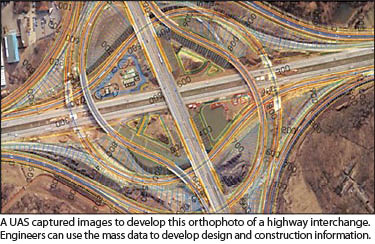
 The demand for mass data continues to drive new technologies. One of the most important is the use of unmanned aircraft systems (UAS) for aerial surveying and mapping. UAS use small autonomous or remotely controlled aircraft equipped with imaging and positioning sensors to capture aerial images of a project site. In the office, desktop software processes hundreds of images into orthophotos and point clouds and then performs modeling, feature extraction, and other analyses.
UAS technology is quickly gaining a foothold for applications that require fast mobilization and frequent observation of project sites. UAS are already demonstrating their capabilities in mining, landfills, and transportation and construction grading, and a long list of other applications will benefit as well. In a world where “change detection” is one of the new deliverables, UAS will play an increasingly valuable role.
The Future
As always, we are in the midst of change. Most surveyors have continued to focus on developing and delivering datasets made of points and vectors. In contrast, mass data collection typically produces raster datasets. By expanding data collection to include photogrammetry, whether from aerial or terrestrial imagery or lidar, the geospatial professionals can instantly become more flexible and versatile. Technologies for collecting, analyzing, and sharing mass data are becoming more widespread and easier to use. More importantly, tools for mass data are finding their way into existing, point-based workflows and deliverables.
The new approaches provide the ability to combine vector and raster data, often from more than two sources, into a single coherent data set. This enables the geospatial professional to select technology and processes that will optimize the data collection speed, accuracy, cost, and value of the information that is delivered to the client.
Mass data collection will continue to expand. In order to meet customer expectations, geospatial professionals will need to develop expertise in a broader set of technologies. There will be much more data “mashing” to combine data from a variety of sources, some from geospatial fields and some from others. (Consider the number and variety of technologies needed to develop a map of a riverbed and the water flowing above it.)
In order to analyze and extract information from these blended datasets, geospatial professionals need to understand how seemingly disparate data contribute to the quality of the end product. Even if the blending results in a relatively simple map, the professional must ensure that the final product provides valid and accurate information to the client and outside users.
The breadth and depth of the contributions that geospatial professionals make to a project—and to society—will result in greater appreciation for spatially based data. And while these professionals may be surveyors at heart, they need to adopt the geospatial label to better describe their capabilities and impact. Some people contend that the future geospatial professional’s work will primarily be in data management, analysis, and information extraction. But that’s only part of the story.
Because finished information can never be a higher quality than the source data, it remains essential that geospatial professionals master new technologies for measurement and data collection. The complexity of data, variety of sources, and information demands of consumers will require the geospatial professional to play an even broader role. Before any data blending can occur, he or she will be actively involved in designing data-collection processes, selecting the appropriate technology, and performing quality assessment.
Although much of this activity will take place in new arenas and at higher levels, these core functions should be familiar to today’s surveyors. As the profession of surveying transitions to that of geospatial professional, today’s surveyors must be sure they are equipped to work at the new levels of performance. In addition to developing and maintaining new skills, technologies, and processes, geospatial professionals must demonstrate their creativity and solid understanding of the role and value that society places on their services.