 If surveyors share one characteristic in general it is their perseverance in the face of adversity. In setting the initial points for the beginnings of surveys in the territories and states, many surveyors suffered hardships that only one who reads the field notes understands. The threat of annihilation from hostile natives, the dread of Yellow Fever or some other deadly contagion, or the sheer physical stress and danger of setting a point in the wilderness were enough to daunt even the most intrepid explorers. None of these deterred the steadfast surveyor in getting the monument set. Yet there are instances when a skilled professional surveyor is not available to face these dangers, and someone else must take on the task.
In the case of Florida in 1824, it was acting-governor, George Walton, who took on the duty because the new surveyor general, Robert Butler, was not yet in the territory, and the governor, William Pope Duval, was negotiating with the natives 22 miles south of Tallahassee to secure the frontier of Florida from attack. A stake was driven in the ground at the point selected by Walton, and Benjamin Clements and Charles C. Stone were hired to run the prime meridian and the basis parallel for the new territory of Florida.
Why the Original Location?
Exactly why this particular spot was chosen is still specifically unknown. According to J. H. Hawes, writing in 1868 in his book, Manual of United States Surveying, the former principal clerk in the General Land Office (GLO) noted: “The first step in proceeding to establish a meridian and base line, will be to select some prominent natural land-mark convenient to the locality where the earliest surveys will be needed, for an initial or starting-point. An isolated, well-defined mountain, or the point of confluence of two rivers afford favorable objects for the purpose indicated. If these are not to be found, some other prominent natural object should be sought for.”
The spot chosen for the initial point in Tallahassee, the new territorial capital, is not far from the banks of the St. Augustine branch, in the swampy lands surrounding this non-navigable water body. It was not an ideal location. Florida surveyor John Gargis, who has researched this dilemma in the official records and published his findings in the Florida Surveyor in January of 2011, speculates, “… George Walton, pointed out to Butler the site which had been selected for the Capitol Building. Butler, Clements, and Stone must have then measured one quarter mile east and one quarter mile south from that point to establish the place for the Initial Point.”
The original proclamation written by Governor Duval noted that the Territorial Legislative Council had indicated the site by stating the point would be located near where an old Spanish trail had intersected “a small trail running southwardly.” Gargis concludes that this is the reason the marker was set in an unlikely and unhealthy spot. Conversely, Jonathan Lammers, who did the most thorough history of the Cascades area for the Florida Department of State, indicated that the area was, in 1824, a healthy, unpolluted spot even though, relative to the surrounding area, fairly low. As the area adjacent to the site is rolling hills one can only wonder at the final choice, and Gargis’ theory is better than any other previously put forth.
Remonumentation Myths
 Local mythology has clouded the story of this monument to an extent that few in Florida or elsewhere understand its actual history. One of the favored myths concerns an effort sometime in the 1850s to move a large rock monument into position, but that for some unexplained reason the rock fell out of the wagon 200 yards shy of the point. Because the 1852 bill introduced in the Florida legislative session for that year was never acted upon, it is highly unlikely that any rock, stone, or boulder was procured for this purpose during that time period. It was a simple resolution with no commitment of money, and as the GLO was in the midst of sorting out the Swamp and Overflowed Lands Act of 1850, a new pre-emption law, and other issues, it had no time or money to invest in a new marker for Florida.
Another of the fables surrounding this monument relates the tale of a 1923 survey for streets in Tallahassee in which the city engineer, “working backwards from other established points,” allegedly dug down into the soil and discovered a “fat-pine” stake that he claimed had been set by Robert Butler in 1823. It is almost impossible to believe that Robert Butler, a savvy and meticulous man, would have allowed himself to set a “fat-pine” stake anywhere as an official of the government. As GLO policy strictly forbade the use of pine for corners (unless it was the only wood available) and cypress and cedar are native in Florida, it is unlikely that Butler would have allowed its use for this most important of all monuments.
Slocum’s Attempt
The first actual remonumentation does not appear in the official records until the city of Tallahassee passed a resolution in 1891 asking the GLO to consider monumenting the site with a more permanent feature. What sparked this move to create a new monument is unknown; however, the commissioner of the General Land Office did reply to surveyor general J. C. Slocum, on December 14, 1891.
Commissioner Thomas H. Carter wrote to Slocum: “I am in receipt of your letter of the 4th instant stating that the mound marking the initial point of public surveys in Florida has been removed, and that a delegation from the city council of Tallahassee has made application for the re-establishment of said mound. You therefore recommend that said initial point be re-established and marked with a permanent monument; also that the latitude and longitude of said point be ascertained for future use in the event of a state contingency.”
 Because this is the first mention of a mound being in place prior to Slocum’s tenure, it gave the city and the surveyor general enough evidence to ask for something more permanent. As neither party recommended anything specific to the GLO, Commissioner Carter advised marking the point with a stone monument eight inches square and three feet high and a mound not less than two and a half feet high. Slocum countered that this would be too small and likely to be stolen easily.
He then suggested a boulder of “15 cwt to a ton” with a top “dressed and the point marked thereon.” Slocum had already advised the commissioner that he could get a competent surveyor for the job at $100 and that he could obtain the suggested boulder for about $20. Because the area is not productive of such a stone, the boulder would have to be procured from the area south of Tallahassee and hauled to the site, which accounted for the higher cost of the boulder quoted to the commissioner.
Slocum also advised the commissioner that he had personally gone over the area and could find no trace of the original monument. This is a somewhat strange statement for Slocum to make because there is no record of his having any surveying experience, and his appointment to the surveyor generalship of Florida came in lieu of an appointment as consul to Havana, Cuba. His only professional training was as a physician who had to move south for his health. Thus, the value of his “personal examination” is suspect.
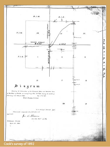
Cook’s (Relative) Success
A local surveyor, John Cook, was appointed as deputy surveyor to re-establish the initial point. Cook’s methodology would, today, be highly questionable and surely not up to minimum technical standards. Cook’s letter describing his methodology is worth quoting because it indicates the type of work he did in finding the original point.
“I would state that from examinations made by me recently and from previous surveys made by me during the last ten years, I find that the original bearing trees and corners are not to be found and I have only been able to find two well established corners viz: the cor. To SW 36, Twp. 1 S. R 1 E. and the ½ mp. on the north line Sec. 31 Twp 1N. R. 1 E. The former is a stake well defined at the intersection of two sec. lines the later, the ½ mp. is a brick corner in a monument of brick established at the intersection of a hedge row and ditch on the north line of Sec. 31 and a ditch line on the East line of Sec. 31 T 1 N. R 1 E. While the corners and old bearing trees are all extinct, still the lines are well defined by ditches and hedge rows which evidently were carefully established on the Sec. lines by the former owners of the properties and the intersections can readily be established.” Other lines, he reported, were obscured by houses built over the Meridian line, and they would require an offset to be properly run.
Cook did not think these interferences with his line of vision would affect the accuracy of his work. Trying to reassure the surveyor general, he also noted that he would use and check “certain city corners that are probably correct.” With such accuracy assured, the surveyor general sent his request forward and was asked to submit his special instructions for Cook’s work. Cook finished the work by May 11, 1892 and sent in his required vouchers and received payment for the job.
What Happened to the Boulder?
Of all the curiosities of this work, one mystery still remains: What happened to the “15 cwt. to one ton” boulder? The city of Tallahassee commission minutes for the time indicate that three men, a cart, and a driver were assigned to help place the monument. No further mention is made of the boulder in the minutes or the local newspaper.
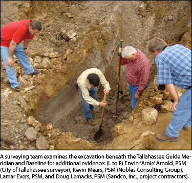
Currently we are erecting a new marker (see the end of this article for details). The creation of Tallahassee’s latest park centered on the property surrounding the monument has forced the temporary removal of our initial point monument, so while that was in transition, we and others felt that it was time to see if there really was such a boulder/stone in the place.
The task was made somewhat more difficult (or easier given the circumstances) by the replacement of the boulder by a monument created by legislative action in 1925. In that year, led by a professional surveyor Peter Kendrick of St. Augustine, then serving as a state representative in the Florida House of Representatives, the legislature authorized the new monument. The new 1925 model was to be placed directly upon the top of the old boulder monument with all of the proper inscriptions and a plaque naming the sponsors, etc. of the monument, including Kendrick. (When the surveyors split off from the engineers in 1931, they created a new registration numbering system, and Peter Kendrick was given the honor of having the number “LS0001.”)
It was hoped that the newer monument would be directly on top of the old as indicated in the drawings submitted to the GLO. The newer monument was moved to the headquarters of the Florida Surveyors and Mappers Society, and the ground beneath exposed for all to see. Alas, no boulder was to be found. A few other items were located near the location but nothing resembling a one-ton boulder. Could the remnants of this gigantic stone still be attached to the newer, 1925 monument?
To test this theory, Lamar Evers contacted Southeastern Surveying and Mapping Corporation that did not hesitate to volunteer its time, staff, and ground-penetrating apparatus to test the theory. The results were negative and conclusive. There was no boulder or remnant thereof attached to the newer monument.
Back to the original question: What happened to the boulder? Several theories were put forth. One of the more interesting was that the boulder was made of Wakulla County limestone and as such it literally melted away with age. Although it is a fascinating geological theory, it’s highly unlikely that a stone that size would dissolve away in the short amount of time it was in the ground at the site.
Another theory put forth was that the stone was “stolen” or chipped away and put to other uses by the locals. Again, the theory is good on paper but not practical in reality. Why would the newer monument be designed to fit over the old boulder if it no longer existed? Although the local newspaper gave coverage to the story of the new marker in 1925, there are no stories to be found indicating the removal of any part or the entire boulder at that time or later. It is likely that no story will be found that indicates the fate of the boulder, and we shall be left to wonder it for some time to come.
Today’s Monument
The new marker will be erected in the near future in the newly redesigned “Cascades Park,” and we are anxious to see it rise. It is designed to hold the names of all of the U.S. deputy surveyors and surveyors general that served in Florida.
Names with more than local interest to be on the monument include Henry Washington, David Burr, Ralph Norris, C. C. Tracy, George Watson, and A. H. Jones. One of the gentlemen named on the monument, Albert W. Gilchrist, served as Florida’s governor and has a county named in his honor. So does surveyor general Benjamin A. Putnam, who served also in the Seminole Wars and was speaker of the Florida House of Representatives. Two of the deputy surveyors, excluding David Burr, moved up to become surveyors general of Florida, i.e. John Westcott and Francis L. Dancy.
The monument will sit in a mini-amphitheatre with a mounted plaque in front explaining its significance to those unfamiliar with surveying’s importance to the development of the state. We strongly feel that this will be a fitting memorial to their perseverance and bravery in surveying Florida’s wilderness and will show the community and visitors alike the role played by the profession in preserving their property lines and civilizing the frontier.