One of the most powerful productivity-boosting tools these days is probably that little machine right there in your pocket. Plenty gets written about how “mobile is taking over the world.” You’ve probably seen your smart phone changing the way you do your work, or maybe it has in ways you haven’t realized—and you could do a lot more with it.
With over a million apps available, you could potentially cobble together a Franken-suite of apps to boost productivity. For instance, with just your phone you could geo-reference photos and notes, do rudimentary measurements, keep an index of control, and manipulate data to get it into some kind of digital map for both field and office. Or, you could use a fully matured and supported solution.
Long before the world got “app-happy,” Terrain Navigator Pro (TNP) was available and could turn a recreational GPS handheld (like a Garmin eTrex) into a powerful tool for conveying low-precision field observations to your desktop. Then with TNP you could integrate the data with maps and aerial imagery, improve workflows for site evaluations, and help in bidding jobs, perform asset inventory and resource mapping, and more. TNP has continued to update and add features requested by a large community of users, and it has now added apps for smartphones and real-time cloud synchronization. It is definitely time for another look at TNP.
Here are a few applications I thought of for project surveyors to use TNP for: scoping out a site, estimating a topo or boundary job, planning scanning projects (to guide a crew where to set up, find control, and set targets), and planning for aerial pre-marks. It can enable individual crew members to do some of the low-precision location/mapping work we sometimes get asked to do, like utility or sign inventories.
Set Up
 To be able to hand these tasks to just about anyone, TNP needs to be easy to deploy. So, to evaluate for this, I handed a copy to a colleague and took one for myself and jumped into it cold turkey.
There are two main components to TNP, and they are designed to synchronize together. There’s TNP desktop program (Windows OS, including Win8) that you purchase per install, and then there’s a companion free app (for Droid or iOS). An individual desktop instance (about $400) installs from a DVD, and it comes with a state-specific resource DVD of maps and aerial images (you can add more states for about half that price each, though you can work a little across a state boundary with just one). Installing the contents of the resource DVD on a local hard drive of a laptop or PC allows you to work offline when needed.
You register the license online and then set up a login to the support website. The support site has a knowledge base of tips and solutions; plus you can go on the support site to download updates of the resource files. Then, you download and install the app on as many smartphones as you’d like; up to two users can use the same login concurrently and synchronize to the same projects and desktop instance, via TNP’s included cloud service.
Mobile App Use
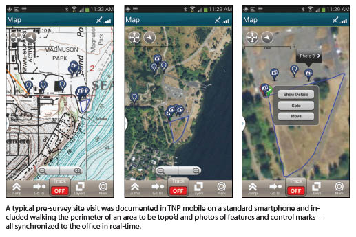
Using the TNP mobile app is very slick, and you can start collecting immediately whether you have data connection or not. Simply open it up, go into the map view, and choose Mark. If you do not already have a project set up, it will prompt you to create one and default to the date for a name (which you can edit). This is cool; just start collecting.
From Mark you can choose to set a mark for a photo, a video, a voice message, or a simple marker. This shows up on the map where your phone’s GPS says it is, and for each type of marker or file it prompts you for a Name for the mark, and a Description. You can even turn tracking on to store a track or route.
I walked around the perimeter of a topo site, took some pictures of specific features, and marked control that a crew could use. I found the photo marks to be the most useful as it stores a description just like a standalone marker. TNP used the full 8Mp of the camera in the phone, previewed the photo, and prompted to save, then prompted to enter optional details.
Synching
 The TNP app can log in (in Settings) to the TNP cloud service, and then you can choose when to start synchronizing what you’ve just observed. If you are out of data connectivity range, it will sync when you re-establish connection. If you take a lot of photos, movies, or voice clips, you might want to wait until you are in WiFi range to avoid eating up the data plan for your phone.
You can have as many as two users logged into the same account and synchronizing to the same project, which is handy for asset and resource inventory jobs. We tested the synchronization of mobile TNP side by side with desktop TNP, and it was pretty much instantaneous; it appears to be updating about every 5-10 seconds
Maps
The maps on the resource data DVD include USGS Topo Quads, Open Streets Maps, and access to MyTopo’s aerial images (looks to be 1m imagery), and even Open Cycle Maps (although designed for cyclists, they are surprisingly detailed). For desktop TNP you can call up Google Maps, and for both desktop and mobile you can add custom overlays. For instance, you can import from Shape files and CAD DXF.
TNP also just announced that they are offering maps and overlays on SD cards for the mobile app. This can include forest roads, public lands, lake contours, and cadastral (from various state and local sources).
You’ve also got several export options, including DXF, Shape, and KML. Working with imports and exports was straight forward. You can draw marks, routes, and polygon features in desktop TNP, and those can show up on the mobile app. Navigating to marks with the mobile app is fairly clear, and you can choose from magnetic north or (what they call) “true.” So far, we haven’t needed to look at a manual or seek help.
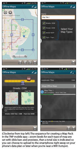
One challenge with maps and images on any mobile is managing potentially large file sizes. TNP has a really cool way to create “Map Packs” to handle this. On the mobile you can pick out a project area and select minimum and maximum zoom levels (with slide bars and previews) for each type of map or photo overlay. The zoom level selection tool is one of the coolest features of TNP mobile because it lets you know how big the files will be so you can decide if you want to download on your phone’s data plan or wait until you are in range of a WiFi hotspot. Once the files in the Map Pack are uploaded to the phone, moving around in the maps and images is pretty fast.
Managing multiple projects and producing maps in desktop TNP is simple, once you know your way around the menus. You can bookmark various views for each project, activate, change project, add marks, routes, and polygons, and import/export. It’s quite easy, but there are no sophisticated “drafting” tools—you can always do that in CAD and import DXFs.
When you produce a map for printing you can save that as a sort of template. This is not a solution designed for high-precision work, engineering drafting, or map production per se, but it is strong at what it does.
TNP supports connections to dozens of GPS recreational handhelds, but it also supports NMEA messages from any device that can output them. It would be possible to connect an instance of desktop TNP (like on a laptop or tablet running Windows 8) to a high-precision GPS receiver via Bluetooth or Serial (although the precision of the observed positions would definitely be greater than the maps and aerial imagery, unless you added your own high precision overlay). TNP was not designed for that, so considering the low cost and the uses I’ve been thinking about, high precision would not be necessary.
Other Uses
I have talked to surveyors who have used TNP for many years with old-school GPS handhelds and, more recently, smartphones. They use TNP for many of the same functions I would: recon, estimating, inventory. Forestry users are another large user segment, as well as environmental users, like for wetlands and other natural features. Hunters, outdoors enthusiasts, geo-cachers, and others also use TNP.
You can see the “footprints” of the various user segments reflected in the features that have been added over the years. For instance, you see an option to show positions as NAD27, WGS84, or UTM (there are many federal, state, and local entities still working with those systems).
For surveyors, desktop TNP provides an overlay of NGS control marks: click on one and you get an NGS datasheet. TNP provides updates of NGS marks periodically (a nice feature if they are, for some reason, unavailable online from the NGS).
For a program that uses low-precision GPS, there was a lot more functionality than I thought. TNP has responded to many user segments over the years and added a lot of features. We spent time exploring the desktop TNP menus. Although it’s easy to deploy without having to dig deeply, I would recommend setting aside a little time to explore the menus. There is a lot in there.
Strengths
The strengths of TNP include the cloud service that comes with a licensed copy.Synchronizing the data from multiple field users is amazing, especially being able to work offline and sync later. But there is one feature that you do not get with a bunch of free/cheap apps: actual support. There is a large community of users, a great knowledge base online, and live phone support. Map Packs, custom overlays, and import/export options complete this field/office solution.
We did find a few things we’d like to see, such as an option for different symbols for marks in the mobile (there are lots of symbols in desktop TNP but not in mobile TNP). First impressions of desktop TNP are deceiving; there is a large existing user base, so the look and feel has not been altered much over the years, but there have been a lot of functionality and features added, buried down the menus. Maybe it just needs a “style” makeover.
We had a lot of fun evaluating TNP, and we can imagine many uses and will likely find more as we get into it deeper. There is always a temptation to do a lot of tinkering and to develop our own solutions, but for this price range, I do not think do-it-yourself can match the functionality and depth of TNP, especially with the cloud service included.