August 2017 Archives
Drones & Surveying Flood Zones
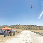
In Juniper Flats, CA, county land surveyors use UAS to save tax dollars and project times and to improve public safety. Photo above: Steven Lewis, Trish Ortega, Paul Clements, Claudio Padres of RCFC & WCD; Sebastien Borghini of Microdrones; Dan McMahon of Allen Instruments. Joshua Tremba does a lot of mapping; he’s the supervising land surveyor […]
Night in the Afternoon: A US Solar Eclipse

What you need to know about the 2017 solar eclipse The upcoming solar eclipse will leave a 70-mile-wide trail of darkness across the United States on August 21, 2017 (see the map of the eclipse path on pages 44-45). This will be a once-in-a-lifetime event for many people. While another total solar eclipse will make […]
Fire, Ice, and Latitude in Ecuador
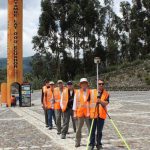
A team of U.S. surveyors visited Ecuador to use real-time PPP to pay homage to the 18th-century “Geodesic Mission to the Equator,” one of the most difficult and significant missions in the history of surveying and geodesy. Pictured above: The team of U.S. surveyors on the 2017 Ecuador visit (from back to front): Rich Leu, John […]
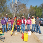
Geomatics at Nicholls State University
A profile of their geomatics program Above: Students receive instructions on laser scanning. L-r: Jessica Freeman, Kent Hebert, Paul LeBlanc, Dr. Balaji Ramachandran, Monica Crout, and Ann Hebert. Nicholls State University in Thibodaux, Louisiana, initiated its new four-year Bachelor of Science degree program in geomatics during the summer semester of 2003. This program is a […]
Photogrammetric Engineering at The National Polytechnic Institute
A profile of their surveying and photogrammetric engineering program Featured image: IPN students doing field work for a class at the National Autonomous University of Mexico in February, 2012. Credit: Roberto Garcia. The Superior School of Engineering and Architecture, Ticomán Unit, is located in the north of Mexico City, Mexico, and offers a degree in surveying […]
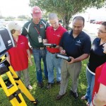
Controlling the Future with Training
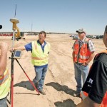
To support user training, one company surpasses the usual by extending and supporting information, content, and new skills. Pictured above: Field training can sometimes be the most efficient way of capturing the attention of busy contractors. The surveying and construction industries are dynamic. The way people work today is clearly much different than 50 years ago, […]