December 2016 Archives
‘Bout Surveyin’, Mate! RADU Remembers
Insights from an Aussie Surveyor Editor’ s note: In listening to peer surveyors from other parts of the world one can experience some rather pronounced revelations – how similar the triumphs and challenges are for the practitioner – often only differing in the lingo of how the tales are told. We are honored to present […]
Custom, Portable Maps — Via App!
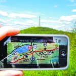
Software company Avenza has evolved its map products into an app that lets people upload their own map—or download a map of their choice—to their mobile devices, and customize it. Whether for fighting a wildland fire, delivering packages, or exploring tourist sites, using a map should be easy and quick. Well, especially when you’re fighting […]
What Is That? The FFOS Needs Your Input
The work of the subcommittee on branding opens many possibilities. Imagine a member of the public: someone who may have never met a surveyor. Or maybe they hired one to mark their property so they could see if a neighbor’s fence is encroaching, or maybe they’ve seen “those people with cameras on tripods” along the […]
Carlson’s BRx5 Receiver: the Birth of a New Instrument
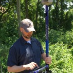
Carlson Software & Hemisphere GNSS Bring a Lightweight Receiver to Market For land surveyors and others in careers that rely on constant use of GPS and GNSS technology, not to mention the millions of consumers with receivers in their smart phones, it is easy to forget that instant location remains technologically miraculous, relying as it […]
DIY Immersive Virtual Reality

With Autodesk LIVE, you can build immersive virtual reality experiences for your clients, stakeholders, and your design team—yes, you. Drawings, renderings, physical models, 3D digital models, drive-throughs, fly-throughs, and walk-throughs–we’ve come a long way in being able to convey designs to clients and stakeholders, but also in communicating to our own teams as an essential […]
Disparate Data for Marine Life
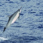
Remote sensing data helps to inform ocean planning for energy development around the main Hawaiian islands. Using remotely sensed imagery to map physical and biological patterns in the marine environment enhances our ability to understand how environmental conditions change over broad spatial scales (10s to 100s of kilometers) and temporal scales (years to decades). These […]